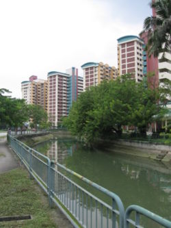
Rochor Canal
Encyclopedia

Canal
Canals are man-made channels for water. There are two types of canal:#Waterways: navigable transportation canals used for carrying ships and boats shipping goods and conveying people, further subdivided into two kinds:...
in the Central Region
Central Region, Singapore
The Central Region of Singapore is one of the five regions in the city-state. Comprising 13,150 hectares of land area, it includes 11 Planning Areas within the Central Area which is the immediate vicinity of the Singapore's central business district, as well as another 11 more outside it.Although...
of Singapore
Singapore
Singapore , officially the Republic of Singapore, is a Southeast Asian city-state off the southern tip of the Malay Peninsula, north of the equator. An island country made up of 63 islands, it is separated from Malaysia by the Straits of Johor to its north and from Indonesia's Riau Islands by the...
. The canal is about 1.4 km in length.
Rochor Canal is a continuation of an unnamed canal that passes through the Bukit Timah
Bukit Timah
Bukit Timah is an area in Singapore and a hill in that area. Bukit Timah is located near the centre of the Singapore main island. The hill stands at an altitude of 163.63 metres and is the highest point in the city-state of Singapore...
area, which starts beneath the junction of Jalan Jurong Kechil and Upper Bukit Timah Road. Officially, Rochor Canal begins beneath Kandang Kerbau Bridge at the junction of Serangoon Road
Serangoon Road
Serangoon Road is a road from Little India to Boon Keng of Singapore . There is another road, from Woodsville Interchange to Sengkang called Upper Serangoon Road.Another way is via Jalan Besar and Bendemeer Road....
and Selegie Road, and ends at the Victoria Bridge beneath the junction of Kallang Road
Kallang Road
Kallang Road is a major road in Singapore linking Sims Avenue/Geylang Road to Victoria Street, serving the area of Kallang....
and Victoria Street
Victoria Street, Singapore
Victoria Street [Tamil]: விக்டோரியா ஸ்திரீட் is a street located in the Central Area of Singapore. The street starts at Victoria Bridge at the end of Kallang Road, after the Immigration and Checkpoints Authority building, in the north and continues as Hill Street at its junction with Stamford Road...
. The canal continues as Rochor River
Rochor River
Rochor River is a canalised river in Kallang of the Central Region in Singapore. The river is about 0.8 km in length....
which empties into the Kallang Basin.

