Route du Nord
Encyclopedia

Quebec
Quebec or is a province in east-central Canada. It is the only Canadian province with a predominantly French-speaking population and the only one whose sole official language is French at the provincial level....
, Canada, connecting Chibougamau
Chibougamau, Quebec
Chibougamau is a town in central Quebec, Canada, located on Lake Gilman. It has a population of 7,563 people , which makes it the largest community in northern Quebec...
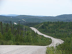
with the James Bay Road (French: Route de la Baie James) at km 275. It is 407 kilometres (252.9 mi) long, all of it unpaved. Extensive logging takes place along the southern half of this road.
There are no services available along the full length of the North Road, except at km 290 at the Cree Construction Company where fuel and repair services are periodically available. Also, fuel, food, and lodging can be obtained in the Cree
Cree
The Cree are one of the largest groups of First Nations / Native Americans in North America, with 200,000 members living in Canada. In Canada, the major proportion of Cree live north and west of Lake Superior, in Ontario, Manitoba, Saskatchewan, Alberta and the Northwest Territories, although...
village of Nemaska
Nemaska, Quebec
Nemaska is a small Cree community located on the shores of Lake Champion, in Quebec, Canada. It is the smallest Cree village with a population of 560 people...
during the day time.
Waypoints
| Km | Mi | |
| 0 | 0 | junction with Route 167 Quebec Route 167 Route 167 is an isolated provincial highway in Quebec, Canada. It begins at the shore of Lac Saint-Jean in Saint-Félicien. It proceeds north-west to Chibougamau away. There are no services along this long stretch. At Chibougamau, the highway turns north-east towards Mistissini.Maps are conflicting... , about 15 km north of Chibougamau |
| 238 | 148 | bridge crossing the Rupert River Rupert River The Rupert River is one of the largest rivers in Quebec, Canada. From its headwaters in Lake Mistassini, the largest natural lake in Québec, it flows west into Rupert Bay on James Bay. The Rupert drains an area of . There is some extremely large whitewater on the river, but paddlers can avoid... |
| 248 | 154 | Hydro-Québec Hydro-Québec Hydro-Québec is a government-owned public utility established in 1944 by the Government of Quebec. Based in Montreal, the company is in charge of the generation, transmission and distribution of electricity across Quebec.... 's Albanel substation Electrical substation A substation is a part of an electrical generation, transmission, and distribution system. Substations transform voltage from high to low, or the reverse, or perform any of several other important functions... |
| 288 | 179 | Hydro-Québec's Nemiscau substation |
| 290 | 180 | Cree Construction Company, services periodically available |
| 291 | 181 | junction with gravel access road to Eastmain-1 power station |
| 296 | 184 | junction with gravel road to Nemaska, 10 km north |
| 407 | 253 | junction with James Bay Road, end of North Road |

