Ruskington
Encyclopedia
Ruskington is a large village in the English county
of Lincolnshire
, on the north-south B1188 road, just north of the A153. The village has approximately 2,200 dwellings, and from east to west is two kilometres long.
burial ground is situated on the Lincoln Road near the Mill House. The remains of a Roman road
also run parallel (west of) to the Lincoln Road, but this is only detailed on aerial photos. Ruskington was recorded in the Domesday Book as Rischintone (Farmstead where rushes grow’. OE *ryscen (with Scand. -sk-) + tūn.), in the ancient Flaxwell Wapentake.
, 20 miles from Newark
& Grantham
, 15 miles from Boston
and Lincoln
; the main surrounding settlements. The landscape is significantly flat. The Spires and Steeples Trail passes north-south through the village, following the River Slea into Sleaford.
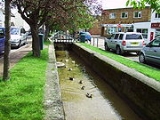
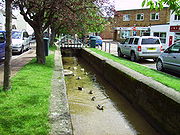
The High Street is split into two parts; High Street North and High Street South, by the Beck, a mini-stream, that flows from Bloxholme five miles west of the village, before disappearing into the Slea
at Haverholme Park. Only after falling into the Beck were you considered a "Ruskingtonian". There is also a large population of Mallard
ducks that inhabit the beck and surrounding gardens.
West of the civil parish is Roxholm. The boundary passes south of Roxholm Grange. On the road to Dunsby, it meets Brauncewell
. It passes eastwards through Cottage Farm, crossing the road to Bloxholm
. It crosses the B1188 Lincoln Road a half-mile north of the village where it meets Dorrington
, skirting the northern-edge of the village.
It crosses the railway south of Cedar Farm (in Dorrington) then follows to the south of the road from Dorrington out onto the fens (Ruskington Fen). At Sylcote it meets North Kyme
, following Farroway Drain to the south at Ruskington Dales. It follows Anwick Bank westwards, where it meets Anwick, to the south. At Highfield, it follows the Anwick road to the south, crossing the A153. North of Haverholme Priory (outside the parish) it meets Ewerby and Evedon at the River Slea
, which it follows for around 300 metres to the west, meeting Leasingham
. It follows the northern edge of the wood westwards along a tributary of the River Slea, then follows parallel to the A153 westwards, to the south. It crosses the A153 south of the 400kV pylons and meets Roxholm at a copse north of Rigg Farm.
Weekly Dads, Lads & Lasses sessions are held during term times.
, which is next to Winchelsea Primary School. This is the former Cotelands School, which merged with the St George's School of Sleaford to become a larger academy. The school had faced problems for many years. In the 1990s it was faced with closure due to its low examination results, and (hence) falling school roll. In 1998 it only had 170 pupils, and gained a pass mark for 5 good GCSEs of 2%, the second lowest in England. By 2003 the pass rate had improved to 38% due to the new headteacher David Veal (a former pupil of Carre's Grammar School
), whose experience with sport helped motivate his pupils. The school had success under his leadership with volleyball
. He retired in 2007 after 13 years as head.
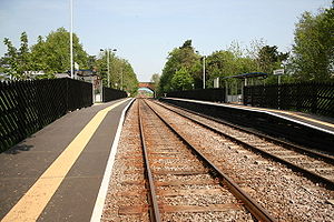 The B1188 road runs all the way through the village, and terminates a mile south of the village, at Speedway Corner. There is also a railway station
, which originally opened on 1 August 1882, and reopened on 5 May 1975. It is on the Peterborough to Lincoln Line
. Trains do not run on Sundays. Ruskington is also on a bus route between Sleaford and Lincoln.
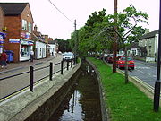 Ruskington's High Street North has a Co-op
(that includes a pharmacy and sub-post office), an optician, farm shop, three charity shops, a carpet shop, three men's barbers, a number of ladies hairdressers, two tea and coffee shops, a florists, one Indian, one kebab, and three Chinese take-aways
, a Chinese restaurant, and two fish and chip
shops, one with a restaurant. On High St South is a bakers and a sweet shop. Church Street has a card shop, a butcher-cum-bakers, and a butchers' cash-and-carry
factory shop. There is a pet supply outlet, and a general supply with hardware shop on Manor St, and two newsagents, a building society-cum-estate agents, a computer shop, and Ruskington Garden Centre on Newton Lane. There is another farm shop on Priory Road, and a petrol station-cum-garage (that includes Spar retailing), on Rectory Road. The village hall is off Parkfield Road.
There is also a veterinary surgery, in Brookside Close, With another vet's surgery on High Street North.
There is a dance school at the village hall on Saturdays, and another on Brookside Close near the Doctors surgery. Also, the village has a local table tennis club which runs every Wednesdays from September to May
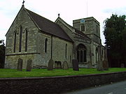 The village is served by several churches. All Saints Parish Church is perhaps the easiest to find, being sited at the west end of the main shopping area. The Norman Church was built in 1086, replacing an earlier, Anglo Saxon, wooden structure. Parts of the tower are believed to remain from this date but the Chancel portion was built in the 13/14th century. The Tower was damaged in 1618 and rebuilt in 1620. There is also the Ruskington Methodist Church, South Lincs Church (a Pentecostal church formerly known as Emmanuel Christian Centre) and Ruskington Free Church.
 Railway Walk
1 From the church, walk along High Street (North) beside The Beck.
2 Turn left along Parkfield Road and take the first right into East Close which leads onto Tomlinson Way. Walk to the far end, then between two houses and over a bridge.
3 Turn right and after approximately 20m, bear left across the field to the hedge/fence bordering the railway line. Cross the stile, look right and left and if clear, cross the double railway track. If a train is visible, return to the hedge until the track is clear. Cross the stile and bear diagonally left towards a lone bush on the skyline. At the field corner and drain, continue in the same direction across the next field.
4 At the field corner and junction of a restricted byway and footpath, turn right along the restricted byway to a road.
5 At the road, turn right and follow it back to the village centre.
River Walk
1 Facing the church gate, turn left along Church Street to a crossroads.
2 Turn left along Station Road.
3 After approximately 350m and after passing Chestnut Street, take the public footpath signed on the left. Pass the school and cross the blue railway footbridge. Walk straight on alongside the hedge and at the second field bear diagonally right to the field corner and bridge.
4 Cross the bridge, turn right and the path opens out into a field, bear left and walk alongside the hedge and enter the next field through a gap in the far hedge. Bear slightly right across the next field to a track.
5 Turn right along the track.
6 At the end of the track, turn right for the SHORTER WALK along the lane and restricted byway. At the junction with the road turn right and follow it into Ruskington. Rejoin the directions at 10.
For the LONGER WALK, turn left at the end of the track along a restricted byway to a main road (A153). Cross this busy road with care and walk straight on along the lane to Haverholme bridge.
7 Cross the bridge and turn right, walk across the car park and follow the footpath alongside the river. At the lock and weir, cross the two bridges and turn left to continue alongside the river but on the opposite bank.
8 After approximately 800m (? mile) and at a fence and sign, turn right and then almost immediately right into a wooded area. Continue through the woodland and then walk straight across the field to a bridge.
9 Cross the bridge and turn left along the edge of the stream. Cross a second bridge and track and follow the footpath diagonally right across the next field, heading for the light-coloured buildings in the distance, to the main road. Cross the road with care and follow the lane opposite into Ruskington.
10 Turn right along Chestnut Street and at the T-junction turn left to return to the start
(previously 'George Adams'), a pork products factory which originally produced mainly sausage
s and pork pie
s.
Tulip's Ruskington site now produces fried crumbed products like Scotch Egg
s and cocktail sausages. It was the manufacturer of Spam fritter
s and Wicked Pigs, but these product have now been discontinued. Stores and local shops provide other employment.
 Near Ruskington on the A15, it has been alleged that a dark figure, sometimes with the appearance of a witch, runs in front of cars, lies across windscreens, and raises a hand as the vehicles drive off.
Counties of England
Counties of England are areas used for the purposes of administrative, geographical and political demarcation. For administrative purposes, England outside Greater London and the Isles of Scilly is divided into 83 counties. The counties may consist of a single district or be divided into several...
of Lincolnshire
Lincolnshire
Lincolnshire is a county in the east of England. It borders Norfolk to the south east, Cambridgeshire to the south, Rutland to the south west, Leicestershire and Nottinghamshire to the west, South Yorkshire to the north west, and the East Riding of Yorkshire to the north. It also borders...
, on the north-south B1188 road, just north of the A153. The village has approximately 2,200 dwellings, and from east to west is two kilometres long.
History
Ruskington's Anglo-SaxonAnglo-Saxon
Anglo-Saxon may refer to:* Anglo-Saxons, a group that invaded Britain** Old English, their language** Anglo-Saxon England, their history, one of various ships* White Anglo-Saxon Protestant, an ethnicity* Anglo-Saxon economy, modern macroeconomic term...
burial ground is situated on the Lincoln Road near the Mill House. The remains of a Roman road
Roman road
The Roman roads were a vital part of the development of the Roman state, from about 500 BC through the expansion during the Roman Republic and the Roman Empire. Roman roads enabled the Romans to move armies and trade goods and to communicate. The Roman road system spanned more than 400,000 km...
also run parallel (west of) to the Lincoln Road, but this is only detailed on aerial photos. Ruskington was recorded in the Domesday Book as Rischintone (Farmstead where rushes grow’. OE *ryscen (with Scand. -sk-) + tūn.), in the ancient Flaxwell Wapentake.
Geography
Ruskington is approximately four miles north of SleafordSleaford
Sleaford is a town in the North Kesteven district of Lincolnshire, England. It is located thirteen miles northeast of Grantham, seventeen miles west of Boston, and nineteen miles south of Lincoln, and had a total resident population of around 14,500 in 6,167 households at the time...
, 20 miles from Newark
Newark-on-Trent
Newark-on-Trent is a market town in Nottinghamshire in the East Midlands region of England. It stands on the River Trent, the A1 , and the East Coast Main Line railway. The origins of the town are possibly Roman as it lies on an important Roman road, the Fosse Way...
& Grantham
Grantham
Grantham is a market town within the South Kesteven district of Lincolnshire, England. It bestrides the East Coast Main Line railway , the historic A1 main north-south road, and the River Witham. Grantham is located approximately south of the city of Lincoln, and approximately east of Nottingham...
, 15 miles from Boston
Boston, Lincolnshire
Boston is a town and small port in Lincolnshire, on the east coast of England. It is the largest town of the wider Borough of Boston local government district and had a total population of 55,750 at the 2001 census...
and Lincoln
Lincoln, Lincolnshire
Lincoln is a cathedral city and county town of Lincolnshire, England.The non-metropolitan district of Lincoln has a population of 85,595; the 2001 census gave the entire area of Lincoln a population of 120,779....
; the main surrounding settlements. The landscape is significantly flat. The Spires and Steeples Trail passes north-south through the village, following the River Slea into Sleaford.
The High Street is split into two parts; High Street North and High Street South, by the Beck, a mini-stream, that flows from Bloxholme five miles west of the village, before disappearing into the Slea
River Slea
The River Slea is an 18-mile long tributary of the River Witham, in Lincolnshire, England. In 1872 the river was described as "a never-ending source of pure water", and was a trout river renowned throughout the East coast of England...
at Haverholme Park. Only after falling into the Beck were you considered a "Ruskingtonian". There is also a large population of Mallard
Mallard
The Mallard , or Wild Duck , is a dabbling duck which breeds throughout the temperate and subtropical Americas, Europe, Asia, and North Africa, and has been introduced to New Zealand and Australia....
ducks that inhabit the beck and surrounding gardens.
West of the civil parish is Roxholm. The boundary passes south of Roxholm Grange. On the road to Dunsby, it meets Brauncewell
Brauncewell
Brauncewell is a hamlet and civil parish in the North Kesteven district of Lincolnshire, England. It lies between Leadenham and Sleaford and is north of, and in close proximity to, RAF Cranwell....
. It passes eastwards through Cottage Farm, crossing the road to Bloxholm
Bloxholm
Bloxholm is a hamlet, and part of the civil parish of Ashby de la Launde and Bloxholm, in the North Kesteven district of Lincolnshire, England. It lies 1 mile south-west of the village of Digby.In Bloxholm there is a semi-ruined Hall....
. It crosses the B1188 Lincoln Road a half-mile north of the village where it meets Dorrington
Dorrington, Lincolnshire
Dorrington is a village and civil parish in the North Kesteven district of Lincolnshire, England. It lies south of Digby and north of Ruskington. It is to the east of the north-south B1188, which lies just within the parish boundaries...
, skirting the northern-edge of the village.
It crosses the railway south of Cedar Farm (in Dorrington) then follows to the south of the road from Dorrington out onto the fens (Ruskington Fen). At Sylcote it meets North Kyme
North Kyme
North Kyme is a village and civil parish on the A153 road, in the North Kesteven district, in the county of Lincolnshire, England. North Kyme is located near the larger village of Billinghay....
, following Farroway Drain to the south at Ruskington Dales. It follows Anwick Bank westwards, where it meets Anwick, to the south. At Highfield, it follows the Anwick road to the south, crossing the A153. North of Haverholme Priory (outside the parish) it meets Ewerby and Evedon at the River Slea
River Slea
The River Slea is an 18-mile long tributary of the River Witham, in Lincolnshire, England. In 1872 the river was described as "a never-ending source of pure water", and was a trout river renowned throughout the East coast of England...
, which it follows for around 300 metres to the west, meeting Leasingham
Leasingham
Leasingham is a village and civil parish in the District of North Kesteven in Lincolnshire, England. It has 713 households and is situated less than two miles north of Sleaford, just off the A15. The hamlet of Roxholme lies to the north.-Geography:...
. It follows the northern edge of the wood westwards along a tributary of the River Slea, then follows parallel to the A153 westwards, to the south. It crosses the A153 south of the 400kV pylons and meets Roxholm at a copse north of Rigg Farm.

Primary Schools
- Chestnut Street School to the east of the village,
- Winchelsea Primary School to the west of the village.
Weekly Dads, Lads & Lasses sessions are held during term times.
Secondary schools
St George's AcademySt George's Academy
St. George's Academy is an English secondary school in North Kesteven, Lincolnshire, England. It was founded in 1908 and has now moved sites to the land it is currently on. In 1994 the School gained specialist schools status as a Technology College. The school's facilities include a childcare...
, which is next to Winchelsea Primary School. This is the former Cotelands School, which merged with the St George's School of Sleaford to become a larger academy. The school had faced problems for many years. In the 1990s it was faced with closure due to its low examination results, and (hence) falling school roll. In 1998 it only had 170 pupils, and gained a pass mark for 5 good GCSEs of 2%, the second lowest in England. By 2003 the pass rate had improved to 38% due to the new headteacher David Veal (a former pupil of Carre's Grammar School
Carre's Grammar School
Carre's Grammar School is a selective school and specialist Sports and Science College located in the market town of Sleaford, in Lincolnshire, England. It was founded in 1604 by Sir Robert Carre...
), whose experience with sport helped motivate his pupils. The school had success under his leadership with volleyball
Volleyball
Volleyball is a team sport in which two teams of six players are separated by a net. Each team tries to score points by grounding a ball on the other team's court under organized rules.The complete rules are extensive...
. He retired in 2007 after 13 years as head.
Transport

Ruskington railway station
Ruskington railway station serves the village of Ruskington in Lincolnshire, England. It opened in 1882 as part of the Great Northern and Great Eastern Joint Railway between Sleaford and Lincoln. It closed in 1961 but was reopened in 1975.-External links:...
, which originally opened on 1 August 1882, and reopened on 5 May 1975. It is on the Peterborough to Lincoln Line
Peterborough to Lincoln Line
The Peterborough to Lincoln Line is a railway line linking and , via and .-History:The section between Peterborough and Spalding closed to passengers on 5 October 1970 and re-opened on 7 June 1971. North of Spalding, Ruskington re-opened on 5 May 1975. Metheringham followed on 6 October...
. Trains do not run on Sundays. Ruskington is also on a bus route between Sleaford and Lincoln.
Shops

Co-op UK
The United Kingdom is home to a widespread and diverse co-operative movement, with over 3 million individual members. Modern co-operation started with the Rochdale Pioneers' shop in the northern English town of Rochdale in 1844....
(that includes a pharmacy and sub-post office), an optician, farm shop, three charity shops, a carpet shop, three men's barbers, a number of ladies hairdressers, two tea and coffee shops, a florists, one Indian, one kebab, and three Chinese take-aways
Take-out
Take-out or takeout , carry-out , take-away , parcel , or tapau , is food purchased at a...
, a Chinese restaurant, and two fish and chip
Fish and chips
Fish and chips is a popular take-away food in the United Kingdom, Australia, New Zealand and Canada...
shops, one with a restaurant. On High St South is a bakers and a sweet shop. Church Street has a card shop, a butcher-cum-bakers, and a butchers' cash-and-carry
Cash and carry (wholesale)
Cash and carry wholesale represents a type of operation within the wholesale sector. Its main features are summarized best by the following definitions:...
factory shop. There is a pet supply outlet, and a general supply with hardware shop on Manor St, and two newsagents, a building society-cum-estate agents, a computer shop, and Ruskington Garden Centre on Newton Lane. There is another farm shop on Priory Road, and a petrol station-cum-garage (that includes Spar retailing), on Rectory Road. The village hall is off Parkfield Road.
Pubs & clubs
There are three pubs. The pubs are the Shoulder of Mutton Inn on Church Street, the Red Lion on High Street North and the Black Bull on Rectory Road. "Potters Restaurant" on Chestnut Street is now closedHealth care
The Medical Centre is situated in Brookside Close, which is signed off Lincoln Road. There is also a dental surgery on High St North, and an optician on High St South.There is also a veterinary surgery, in Brookside Close, With another vet's surgery on High Street North.
Sport
It has a bowls club, and children's football teams called Ruskington Lions; the Ruskington Lions girls team is now entering a newly founded Lincolnshire County Intermediate Womans Football League.There is a dance school at the village hall on Saturdays, and another on Brookside Close near the Doctors surgery. Also, the village has a local table tennis club which runs every Wednesdays from September to May
Churches

Walks

1 From the church, walk along High Street (North) beside The Beck.
2 Turn left along Parkfield Road and take the first right into East Close which leads onto Tomlinson Way. Walk to the far end, then between two houses and over a bridge.
3 Turn right and after approximately 20m, bear left across the field to the hedge/fence bordering the railway line. Cross the stile, look right and left and if clear, cross the double railway track. If a train is visible, return to the hedge until the track is clear. Cross the stile and bear diagonally left towards a lone bush on the skyline. At the field corner and drain, continue in the same direction across the next field.
4 At the field corner and junction of a restricted byway and footpath, turn right along the restricted byway to a road.
5 At the road, turn right and follow it back to the village centre.
River Walk
1 Facing the church gate, turn left along Church Street to a crossroads.
2 Turn left along Station Road.
3 After approximately 350m and after passing Chestnut Street, take the public footpath signed on the left. Pass the school and cross the blue railway footbridge. Walk straight on alongside the hedge and at the second field bear diagonally right to the field corner and bridge.
4 Cross the bridge, turn right and the path opens out into a field, bear left and walk alongside the hedge and enter the next field through a gap in the far hedge. Bear slightly right across the next field to a track.
5 Turn right along the track.
6 At the end of the track, turn right for the SHORTER WALK along the lane and restricted byway. At the junction with the road turn right and follow it into Ruskington. Rejoin the directions at 10.
For the LONGER WALK, turn left at the end of the track along a restricted byway to a main road (A153). Cross this busy road with care and walk straight on along the lane to Haverholme bridge.
7 Cross the bridge and turn right, walk across the car park and follow the footpath alongside the river. At the lock and weir, cross the two bridges and turn left to continue alongside the river but on the opposite bank.
8 After approximately 800m (? mile) and at a fence and sign, turn right and then almost immediately right into a wooded area. Continue through the woodland and then walk straight across the field to a bridge.
9 Cross the bridge and turn left along the edge of the stream. Cross a second bridge and track and follow the footpath diagonally right across the next field, heading for the light-coloured buildings in the distance, to the main road. Cross the road with care and follow the lane opposite into Ruskington.
10 Turn right along Chestnut Street and at the T-junction turn left to return to the start
People from Ruskington
- George Davy KelleyGeorge Davy KelleyGeorge Davy Kelley was a British trades unionist and Labour politician.Kelley was born in Ruskington, Lincolnshire in 1848. He became apprenticed to the lithographic printing trade in York. Following his apprenticeship, he worked as a printer in London, Birmingham, Leeds and Bradford...
, Labour MP from 1906-10 for Manchester South WestManchester South West (UK Parliament constituency)Manchester South West was one of six single-member Parliamentary constituencies created in 1885 by the division of the existing three-member Parliamentary Borough of Manchester... - Sir Robert PattinsonSir Robert PattinsonSir Robert Pattinson was the Chairman of Kesteven County Council for 20 years and briefly a Liberal MP.-Family and education:...
, Liberal MP from 1922-3 for GranthamGrantham (UK Parliament constituency)Grantham was a Parliamentary constituency in Lincolnshire, England.The constituency was created in 1468 as a parliamentary borough which elected two Members of Parliament to the House of Commons of the Parliament of England until the union with Scotland, and then to the Parliament of Great Britain... - Samuel PattinsonSamuel PattinsonSamuel Pattinson was a British businessman and Liberal politician.-Family and education:Samuel Pattinson was the son of William Pattinson, a Justice of the Peace from Ruskington in Lincolnshire. He was educated at Abingdon House School in Northampton. In 1897 he married Betsy Sharpley Bainbridge...
, Liberal MP from 1922-4 for HorncastleHorncastle (UK Parliament constituency)Horncastle was a county constituency in Lincolnshire which returned one Member of Parliament to the House of Commons of the Parliament of the United Kingdom. MPs were elected by the first past the post system of voting.... - Abi TitmussAbi TitmussAbi Titmuss, , is a former English nurse turned glamour model, television personality and actress.-Early life:...
, former English nurse turned glamour model and actress
Employment
The main employer in Ruskington is Tulip, a division of Danish CrownDanish Crown AmbA
Danish Crown AmbA is a Danish food processing company, dealing primarily in meat processing of pork and beef. It is Europe's largest pork producer. Through its subsidiaries, known as the Danish Crown Group, it is also involved in a long list of other food products...
(previously 'George Adams'), a pork products factory which originally produced mainly sausage
Lincolnshire sausage
Lincolnshire sausages are a distinctive variety of pork sausage developed in and associated with the English county of Lincolnshire.A widely available variety at most UK butchers and supermarkets, the sausage is commonly dominated by the herb sage, rather than the more peppery flavour balance found...
s and pork pie
Pork pie
A pork pie is a traditional British meat pie. It consists of roughly chopped pork and pork jelly sealed in a hot water crust pastry . It is normally eaten cold as a snack or as part of a meal.-Types:...
s.
Tulip's Ruskington site now produces fried crumbed products like Scotch Egg
Scotch egg
A Scotch egg consists of a hard-boiled egg wrapped in a sausage meat mixture, coated in breadcrumbs or rolled oats, and deep-fried...
s and cocktail sausages. It was the manufacturer of Spam fritter
Spam fritter
A spam fritter is a slice of Spam fried in batter. Commonly eaten with chips and mushy peas, spam fritters are served in fish and chip shops in England. They were first introduced during World War II due to fish being unavailable...
s and Wicked Pigs, but these product have now been discontinued. Stores and local shops provide other employment.
Ruskington Horror


