

Saddle Hill, New Zealand
Encyclopedia
Taieri Plains
The Taieri Plains are an area of fertile agricultural land to the southwest of Dunedin, in Otago, New Zealand. The plains cover an area of some 300 square kilometres, with a maximum extent of 30 kilometres....
in Otago
Otago
Otago is a region of New Zealand in the south of the South Island. The region covers an area of approximately making it the country's second largest region. The population of Otago is...
, New Zealand
New Zealand
New Zealand is an island country in the south-western Pacific Ocean comprising two main landmasses and numerous smaller islands. The country is situated some east of Australia across the Tasman Sea, and roughly south of the Pacific island nations of New Caledonia, Fiji, and Tonga...
. Within the limits of Dunedin
Dunedin
Dunedin is the second-largest city in the South Island of New Zealand, and the principal city of the Otago Region. It is considered to be one of the four main urban centres of New Zealand for historic, cultural, and geographic reasons. Dunedin was the largest city by territorial land area until...
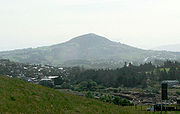
city, it is located 18 kilometres to the west of the city centre, between Mosgiel
Mosgiel
Mosgiel is an urban satellite of Dunedin in Otago, New Zealand, fifteen kilometres west of the city's centre. Since the re-organisation of New Zealand local government in 1989 it has been inside the Dunedin City Council area, but was physically separate from the contiguous suburbs until...
and Green Island
Green Island, New Zealand
Green Island is an island off the coast of Dunedin, New Zealand, also the name of one of the city's suburbs. The suburb is not on the sea — formerly a borough, it took its name from the Green Island bush, uncleared native forest extending from the valley where the town is centred over the hills...
, and is clearly visible from many of the city's southern hill suburbs. A lookout on the northern slopes of the hill commands a good view across the plains, with Lake Waihola
Lake Waihola
Lake Waihola is a tidal freshwater lake located 15 km north of Milton in Otago, in New Zealand's South Island. Its area is some 9 square kilometres, with a maximum length of 6 kilometres....
visible 25 kilometres to the west in clear weather.
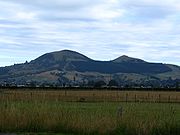
The hill has two peaks: the eastern is the higher, rising to 473 metres; the western peak - Jaffrays Hill - rises to 431 metres.
Of largely volcanic origin, the hill is part of the extinct Dunedin Volcano complex, with a base of Cretaceous
Cretaceous
The Cretaceous , derived from the Latin "creta" , usually abbreviated K for its German translation Kreide , is a geologic period and system from circa to million years ago. In the geologic timescale, the Cretaceous follows the Jurassic period and is followed by the Paleogene period of the...
breccia
Breccia
Breccia is a rock composed of broken fragments of minerals or rock cemented together by a fine-grained matrix, that can be either similar to or different from the composition of the fragments....
overlaid with Miocene
Miocene
The Miocene is a geological epoch of the Neogene Period and extends from about . The Miocene was named by Sir Charles Lyell. Its name comes from the Greek words and and means "less recent" because it has 18% fewer modern sea invertebrates than the Pliocene. The Miocene follows the Oligocene...
igneous rocks, these in turn overlaid with Cenozoic
Cenozoic
The Cenozoic era is the current and most recent of the three Phanerozoic geological eras and covers the period from 65.5 mya to the present. The era began in the wake of the Cretaceous–Tertiary extinction event at the end of the Cretaceous that saw the demise of the last non-avian dinosaurs and...
sediments.
The hill was - along with Cape Saunders
Cape Saunders
Cape Saunders is a prominent headland on the Pacific Ocean coast of the Otago Peninsula in New Zealand's South Island. It is home to the Cape Saunders Lighthouse....
on the Otago Peninsula
Otago Peninsula
The Otago Peninsula is a long, hilly indented finger of land that forms the easternmost part of Dunedin, New Zealand. Volcanic in origin, it forms one wall of the eroded valley that now forms Otago Harbour. The peninsula lies south-east of Otago Harbour and runs parallel to the mainland for...
- one of just two places in Otago to have been named by Captain James Cook on his 1769 voyage of discovery. Cook described the hill in his journal as "a remarkable saddle". According to pre-European Māori tradition
Maori mythology
Māori mythology and Māori traditions are the two major categories into which the legends of the Māori of New Zealand may usefully be divided...
, the hill is the remains of a taniwha
Taniwha
In Māori mythology, taniwha are beings that live in deep pools in rivers, dark caves, or in the sea, especially in places with dangerous currents or deceptive breakers...
called Meremere and the northern and southern peaks of hill were known by Māori by the names Makamaka and Pikiwara respectively. Early settlers' maps occasionally record the hill as "Saddleback Hill".
A small coal seam on the hill was exploited by early European settlers, and was mined from as early as 1849, the first coal mine in the country. Jaffrays Hill (often wrongly called Jeffrey's Hill, and named for the Jaffray family who owned the land from 1849 until 1937), was extensively mined for basalt
Basalt
Basalt is a common extrusive volcanic rock. It is usually grey to black and fine-grained due to rapid cooling of lava at the surface of a planet. It may be porphyritic containing larger crystals in a fine matrix, or vesicular, or frothy scoria. Unweathered basalt is black or grey...
gravel until the mid 1980s. A DCC landscape architect reviewed the visual effects of quarrying in 2008 after concerns from local residents, and found the hill to be "relatively unchanged".