Saemangeum
Encyclopedia


Estuary
An estuary is a partly enclosed coastal body of water with one or more rivers or streams flowing into it, and with a free connection to the open sea....
tidal flat on the coast of the Yellow Sea
Yellow Sea
The Yellow Sea is the name given to the northern part of the East China Sea, which is a marginal sea of the Pacific Ocean. It is located between mainland China and the Korean Peninsula. Its name comes from the sand particles from Gobi Desert sand storms that turn the surface of the water golden...
in South Korea
South Korea
The Republic of Korea , , is a sovereign state in East Asia, located on the southern portion of the Korean Peninsula. It is neighbored by the People's Republic of China to the west, Japan to the east, North Korea to the north, and the East China Sea and Republic of China to the south...
. It was dammed by the government of South Korea
Government of South Korea
The Government of South Korea is divided into executive, judicial, and legislative branches. The executive and judicial branches operate primarily at the national level, although various ministries in the executive branch also carry out local functions. Local governments are semi-autonomous, and...
's Saemangeum Seawall Project
Saemangeum Seawall
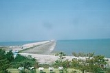
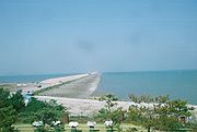
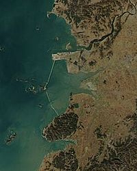
The Saemangeum Seawall, located on the southwest coast of the Korean peninsula, is the world's longest man-made dyke, measuring 33 kilometres. It runs between two headlands, and separates the Yellow Sea and the former Saemangeum estuary....
, completed in April 2006, after a long fight between the government and environmental activists, and is scheduled to be converted into either agricultural or industrial land. Prior to 2006, it had played an important role as a habitat for migratory birds. The completion of this seawall is likely to be a major contributor to the decline of many species. Around 400,000 shorebirds depended on the Saemangeum estuarine as an important feeding ground on the 24,000 km migration between Asia and Alaska and Russia, including the two endangered waders Nordmann's Greenshank and Spoon-billed Sandpiper
Spoon-billed Sandpiper
The Spoon-billed Sandpiper , is a small wader which breeds in northeastern Russia and winters in Southeast Asia.- Taxonomy and systematics :...
(each species with less than a thousand surviving birds). A conservation organisation has accused authorities of having failed to monitor the project's impact on local wildlife in a transparent way, and carried out an independent monitoring program in 2006.
The Saemangeum lay at the mouths of the Dongjin and Mangyeong Rivers, on the coast of Jeollabuk-do
Jeollabuk-do
Jeollabuk-do is a province in the southwest of South Korea. The province was formed in 1896 from the northern half of the former Jeolla province, and remained a province of Korea until the country's division in 1945, then became part of South Korea...
. It is just south of the estuary of the Geum River
Geum River
The Geum-gang River is located in South Korea. It is a major river that originates in Jangsu-eub, North Jeolla Province. It flows northward through North Jeolla and North Chungcheong Provinces and then changes direction in the vicinity of Greater Daejeon and flows southwest through South...
. Neighboring districts include Gunsan
Gunsan
Gunsan is a city in North Jeolla Province, South Korea. It is located on the south bank of the Geum River just upstream from its exit into the Yellow Sea. Gunsan is served by frequent railway service on the Gunsan Line from Iksan. It is also connected to the Seohaean Expressway.Kunsan Air Base...
City, Buan County
Buan County
Buan County is a county in North Jeolla Province, South Korea. It is bounded by the city of Jeongeup on the east, the county of Gochang on the south, the city of Gimje on the north, and Yellow Sea on the west. Buan is divided into 1 eup, 12 myeon, and 503 ri. Buan had a 2008 estimated population...
, and Gimje City.
The project of filling in the estuary began in 1991, but was slowed by a series of court actions by environmentalists. The completed seawall
Seawall
A seawall is a form of coastal defence constructed where the sea, and associated coastal processes, impact directly upon the landforms of the coast. The purpose of a seawall is to protect areas of human habitation, conservation and leisure activities from the action of tides and waves...
is some 33 kilometers long, and replaces a coastline that was once more than 100 kilometers long. After the estuary has been completely filled, an area of about 400 km² (roughly two-thirds the size of Seoul
Seoul
Seoul , officially the Seoul Special City, is the capital and largest metropolis of South Korea. A megacity with a population of over 10 million, it is the largest city proper in the OECD developed world...
) will have been added to the Korean peninsula
Korean Peninsula
The Korean Peninsula is a peninsula in East Asia. It extends southwards for about 684 miles from continental Asia into the Pacific Ocean and is surrounded by the Sea of Japan to the south, and the Yellow Sea to the west, the Korea Strait connecting the first two bodies of water.Until the end of...
, making it one of the biggest land reclamation projects in history.
The estuary was originally called "Mangeum" (萬金). This name was probably formed from combining the first character
Hanja
Hanja is the Korean name for the Chinese characters hanzi. More specifically, it refers to those Chinese characters borrowed from Chinese and incorporated into the Korean language with Korean pronunciation...
of "Mangyeong" and that of "Gimje."
Saemanguem was completed on April 27, 2010, officially becoming the longest seawall
Seawall
A seawall is a form of coastal defence constructed where the sea, and associated coastal processes, impact directly upon the landforms of the coast. The purpose of a seawall is to protect areas of human habitation, conservation and leisure activities from the action of tides and waves...
ever built with the length of 33.9 km, breaking the record of Zuiderzee Works
Zuiderzee Works
The Zuiderzee Works are a manmade system of dams, land reclamation and water drainage works, the largest hydraulic engineering project undertaken by the Netherlands during the twentieth century. The project involved the damming of the Zuiderzee, a large, shallow inlet of the North Sea, and the...
.
On August 2, 2010, Saemanguem was certified by Guinness World Records
Guinness World Records
Guinness World Records, known until 2000 as The Guinness Book of Records , is a reference book published annually, containing a collection of world records, both human achievements and the extremes of the natural world...
as the longest man-made sea barrier in the world.
See also
- Environment of South KoreaEnvironment of South KoreaThe environment of South Korea is the natural environment of the South Korean nation, which occupies the southern half of the Korean peninsula.-Flora and fauna:...
- Geography of South KoreaGeography of South KoreaSouth Korea is located in East Asia, on the southern half of the Korean Peninsula jutting out from the far east of the Asian land mass. The only country with a land border to South Korea is North Korea, lying to the north with of border running along the DMZ. South Korea is mostly surrounded by...
- Rivers of South Korea
- Saemangeum SeawallSaemangeum SeawallThe Saemangeum Seawall, located on the southwest coast of the Korean peninsula, is the world's longest man-made dyke, measuring 33 kilometres. It runs between two headlands, and separates the Yellow Sea and the former Saemangeum estuary....

