

San Francisco Bay Trail
Encyclopedia
San Francisco Bay
San Francisco Bay is a shallow, productive estuary through which water draining from approximately forty percent of California, flowing in the Sacramento and San Joaquin rivers from the Sierra Nevada mountains, enters the Pacific Ocean...
. As of 2011, approximately 310 miles (499 km) of trail have been completed. When finished, the Bay Trail will extend over 500 miles (805 km) to link the shoreline of nine counties, passing through 47 cities and crossing seven toll bridges. It is a project of the Association of Bay Area Governments
Association of Bay Area Governments
The Association of Bay Area Governments is a regional planning agency incorporating various local governments in the San Francisco Bay Area in California. It deals with land use, housing, environmental quality, and economic development. Non-profit organizations as well as governmental...
.
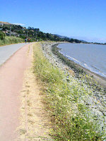
The Bay Trail is a collaboration between elected officials, government agencies, private companies, non-profit organizations, advocacy groups and the public to increase access to the edge of the bay. It provides easily accessible recreational opportunities for hikers, bicyclists and other outdoor enthusiasts; offers a setting for wildlife viewing and environmental education; increases public respect and appreciation for the bay; and serves as a bicycle transportation corridor. The Bay Trail provides access to points of historic, natural and cultural interest, and to numerous recreational areas, including over 100 parks. Depending on its location, the Bay Trail consists of paved paths, gravel trails, bike lanes or sidewalks.
Trail Sections
Sections of the Bay Trail exist in all nine Bay Area counties. The longest continuous segments include: 25 miles (40 km) in San Mateo County between Millbrae and San Carlos; 26 miles (41 km) primarily on gravel levees between East Palo Alto and San Jose in Santa Clara County; 17 miles (27 km) in central Alameda County from San Leandro to Hayward; and 15 miles (24 km) along the shoreline and on city streets through Richmond in Contra Costa County.Bicycle and pedestrian pathways exist on four Bay Area toll bridges: Golden Gate Bridge, Carquinez Bridge, Benicia-Martinez Bridge and Dumbarton Bridge. A bridge pathway is under construction on the East Span of the new San Francisco-Oakland Bay Bridge between Oakland and Yerba Buena Island with a scheduled opening in late 2013.
Maps of the Bay Trail system, including recommended hikes and bike rides, are available for purchase on the Bay Trail website .
Trail access to the bay is also proposed in the planned San Francisco Bay Area Water Trail. The California Coastal Conservancy approved funding in March 2011 to designate trailheads, provide education, and develop the non-motorized water trail.