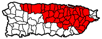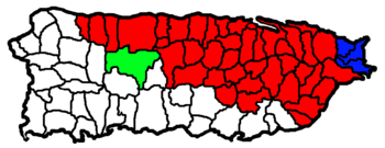
San Juan-Caguas-Guaynabo metropolitan area
Encyclopedia

United States Census Bureau
The United States Census Bureau is the government agency that is responsible for the United States Census. It also gathers other national demographic and economic data...
defined Metropolitan Statistical Area (MSA) in northeastern Puerto Rico
Puerto Rico
Puerto Rico , officially the Commonwealth of Puerto Rico , is an unincorporated territory of the United States, located in the northeastern Caribbean, east of the Dominican Republic and west of both the United States Virgin Islands and the British Virgin Islands.Puerto Rico comprises an...
. A July 1, 2009 Census Bureau estimate placed the population at 2,617,089, a 4.31% increase over the 2000 census
United States Census, 2000
The Twenty-second United States Census, known as Census 2000 and conducted by the Census Bureau, determined the resident population of the United States on April 1, 2000, to be 281,421,906, an increase of 13.2% over the 248,709,873 persons enumerated during the 1990 Census...
figure of 2,509,007.
San Juan-Caguas-Guaynabo is the largest metropolitan area (by population) in Puerto Rico.
Municipalities
A total of forty-one municipalities (SpanishSpanish language
Spanish , also known as Castilian , is a Romance language in the Ibero-Romance group that evolved from several languages and dialects in central-northern Iberia around the 9th century and gradually spread with the expansion of the Kingdom of Castile into central and southern Iberia during the...
: municipios) are included as part of the San Juan-Caguas-Guaynabo Metropolitan Statistical Area. They are:
|
Cayey, Puerto Rico Cayey is a mountain town in central Puerto Rico located on the Central Mountain range, north of Salinas and Guayama; south of Cidra and Caguas; east of Aibonito and Salinas; and west of San Lorenzo Cayey is spread over 21 wards and Cayey Pueblo... Ciales, Puerto Rico Ciales is a municipality of Puerto Rico, located on the Central Mountain Range, northwest of Orocovis; south of Florida and Manatí; east of Utuado and Jayuya; and west of Morovis. Ciales is spread over eight wards and Ciales Pueblo... Cidra, Puerto Rico Cidra is a municipality of Puerto Rico located in the central region of the island, north of Cayey; south of Comerío and Aguas Buenas; east of Aibonito and Barranquitas; and west of Caguas. Cidra is spread over 12 wards and Cidra Pueblo... Comerío, Puerto Rico Comerío is a municipality of Puerto Rico located in the center-eastern region of island, north of Aibonito; south of Naranjito and Bayamón; east of Barranquitas; and west of Cidra and Aguas Buenas. Comerío is spread over 7 wards and Comerío Pueblo... Corozal, Puerto Rico Corozal is a municipality of Puerto Rico located in the central-eastern region, north of Orocovis and Barranquitas; south Vega Alta; southwest of Toa Alta; east of Morovis and Orocovis; and west of Naranjito. Corozal is spread over 12 wards and Corozal Pueblo... Dorado, Puerto Rico Dorado is a small tourist town in the northern coast of Puerto Rico, west of San Juan and is located in the northern region of the island, bordering the Atlantic Ocean, north of Toa Alta, east of Vega Alta, and west of Toa Baja. Dorado is spread over five barrios and Dorado Pueblo... Florida, Puerto Rico Florida is a municipality of Puerto Rico located north of Ciales, south of Barceloneta, east of Arecibo, and west of Manatí. Florida is spread over one ward and Florida Pueblo... Guaynabo, Puerto Rico Guaynabo is a municipality in the northern part of Puerto Rico, located in the northern coast of the island, north of Aguas Buenas; south of Cataño; east of Bayamón; and west of San Juan... --Principal City Gurabo, Puerto Rico Gurabo is a municipality in eastern Puerto Rico located in the central eastern region, north of San Lorenzo; south of Trujillo Alto; east of Caguas; and west of Carolina and Juncos. Gurabo is spread over 9 wards and Gurabo Pueblo... Hatillo, Puerto Rico Hatillo is a municipality located on Puerto Rico's north coast, bordered by the Atlantic Ocean to the north, Lares and Utuado to the south, Camuy to the west, and Arecibo to the east. According to the 2000 US Census Hatillo is spread over 9 wards and Hatillo Pueblo... |
Humacao, Puerto Rico Humacao is a city in Puerto Rico located in the eastern coast of the island, north of Yabucoa; south of Naguabo; east of Las Piedras; and west of Vieques Passage. Humacao is spread over 10 wards and Humacao Pueblo... Juncos, Puerto Rico Juncos is one of the 78 municipalities of Puerto Rico located in the eastern central region of the island, south of Canóvanas and Carolina; southeast of Gurabo; east of San Lorenzo; and west of Las Piedras. Juncos is spread over 9 wards and Juncos Pueblo... Las Piedras, Puerto Rico Las Piedras is a municipality in east Puerto Rico located in the center region of the island, north of Yabucoa; south of Canóvanas and Río Grande; east of Juncos and San Lorenzo; and west of Naguabo and Humacao. Las Piedras is spread over 7 wards and Las Piedras Pueblo... Loíza, Puerto Rico Loíza is a small town and municipality in the northeastern coast of Puerto Rico, north of Canóvanas; east of Carolina; and west of Río Grande. Loíza is spread over 5 wards and Loíza Pueblo... Manatí, Puerto Rico Manatí is a municipality of Puerto Rico in the northern coast, north of Morovis and Ciales; east of Florida and Barceloneta; and west of Vega Baja. Manatí is spread over 8 wards and Manatí Pueblo... Maunabo, Puerto Rico Maunabo is a municipality of Puerto Rico located in the southeastern coast, northeast of Patillas and south of Yabucoa. Maunabo is spread over 8 wards and Maunabo Pueblo . It is part of the San Juan-Caguas-Guaynabo Metropolitan Statistical Area.The Mayor of the town is Jorge L. Márquez Pérez... Morovis, Puerto Rico Morovis is a municipality of Puerto Rico located in the central region of the island, north of Orocovis, south of Manatí, Vega Baja and Vega Alta; east of Ciales, and west of Corozal. Morovis is spread over 13 wards and Morovis Pueblo... Nagüabo, Puerto Rico Naguabo is a municipality in Puerto Rico located in the east coast of the island, north of Humacao; south of Río Grande and Ceiba; and east of Las Piedras. Naguabo is spread over 8 wards and Naguabo Pueblo... Naranjito, Puerto Rico Naranjito is a municipality of Puerto Rico located in the central region of the island, south of Toa Alta; north of Barranquitas and Comerío; east of Corozal; and west of Bayamón. Naranjito is spread over 15 wards and Naranjito Pueblo... Orocovis, Puerto Rico Orocovis is a municipality of Puerto Rico located in the Central Mountain Range, north of Villalba and Coamo; south of Morovis and Corozal; southeast of Ciales; east of Jayuya; and west of Barranquitas... |
Quebradillas, Puerto Rico Quebradillas is a municipality of the island of Puerto Rico, located in the north-western shore bordering the Atlantic Ocean, north of San Sebastián; east of Isabela; and west of Camuy. Quebradillas is spread over swven wards and Quebradillas Pueblo... Río Grande, Puerto Rico Río Grande is a municipality of Puerto Rico located in the Northern Coastal Valley, North of Las Piedras, Naguabo and Ceiba; east of Loíza and Canóvanas and west of Luquillo. Río Grande is spread over eight wards and Río Grande Pueblo... San Juan, Puerto Rico San Juan , officially Municipio de la Ciudad Capital San Juan Bautista , is the capital and most populous municipality in Puerto Rico, an unincorporated territory of the United States. As of the 2010 census, it had a population of 395,326 making it the 46th-largest city under the jurisdiction of... --Principal City San Lorenzo, Puerto Rico San Lorenzo is a municipality of Puerto Rico located in the eastern central region, north of Patillas and Yabucoa; south of Gurabo; east of Caguas and Cayey; and west of Juncos and Las Piedras. San Lorenzo is spread over ten wards and San Lorenzo Pueblo... Toa Alta, Puerto Rico Toa Alta is a municipality of Puerto Rico located in the northern coast of the island, north of Naranjito; south of Dorado and Toa Baja; east of Vega Alta and Corozal; and west of Bayamón. Toa Alta is spread over eight wards and Toa Alta Pueblo... Toa Baja, Puerto Rico Toa Baja is a municipality of Puerto Rico located in the northern coast, north of Toa Alta and Bayamón; east of Dorado; and west of Cataño. Toa Baja is spread over 5 wards and Toa Baja Pueblo . It is part of the San Juan-Caguas-Guaynabo Metropolitan Statistical Area.Toa Baja considered to be a... Trujillo Alto, Puerto Rico -Barrios :*Carraízo*Las Cuevas*Dos Bocas*La Gloria*Quebrada Grande*Quebrada Negrito*Saint Just*Trujillo Alto Pueblo*Cooperativa Jardines de Trujillo Alto-Geo/Topography:*Carraízo dam... Vega Alta, Puerto Rico Vega Alta is a municipality of Puerto Rico. Vega Alta is located on the northern coast of the island, north of Morovis and Corozal; east of Vega Baja; and west of Dorado with an area of . Vega Alta is spread over seven wards and Vega Alta Pueblo... Vega Baja, Puerto Rico Vega Baja is a municipality in north central Puerto Rico located in the northern coast, north of Morovis; east of Manatí; and west of Vega Alta. Vega Baja is spread over 13 wards and Vega Baja Pueblo... Yabucoa, Puerto Rico Yabucoa is a small town in the south eastern tip of Puerto Rico located in the southeastern region, north of Maunabo; south of San Lorenzo, Las Piedras and Humacao; and east of Patillas and about one hour from San Juan. Yabucoa is spread over 9 wards and Yabucoa Pueblo... |
Combined Statistical Area

Fajardo, Puerto Rico
Fajardo is a small city in Puerto Rico located in the east region of the island, bordering the Atlantic Ocean, north of Ceiba and east of Luquillo.Fajardo is spread over 7 wards and Downtown Fajardo , which serves as the administrative center of the city...
Combined Statistical Area (CSA) includes two metropolitan areas
United States metropolitan area
In the United States a metropolitan statistical area is a geographical region with a relatively high population density at its core and close economic ties throughout the area. Such regions are not legally incorporated as a city or town would be, nor are they legal administrative divisions like...
, one micropolitan area
United States micropolitan area
United States Micropolitan Statistical Areas , as defined by the United States Office of Management and Budget, are urban areas in the United States based around a core city or town with a population of 10,000 to 49,999. The micropolitan area designation was created in 2003...
, and forty-five municipalities. A July 1, 2009 Census Bureau estimate placed the population at 2,732,036, a 4.16% increase over the 2000 census
United States Census, 2000
The Twenty-second United States Census, known as Census 2000 and conducted by the Census Bureau, determined the resident population of the United States on April 1, 2000, to be 281,421,906, an increase of 13.2% over the 248,709,873 persons enumerated during the 1990 Census...
figure of 2,622,876. The San Juan–Caguas–Fajardo Combined Statistical Area comprises 68.9% of Puerto Rico's total population.
Components
- Metropolitan Statistical Areas (MSAs)
- FajardoFajardo metropolitan areaThe Fajardo Metropolitan Statistical Area is a United States Census Bureau defined Metropolitan Statistical Area in northeastern Puerto Rico...
(3 Municipalities) - San Juan–Caguas–Guaynabo (41 Municipalities)
- Fajardo
- Micropolitan Statistical Areas (μSAs)
- Utuado (1 Municipality)

