San Luis Pass
Encyclopedia

Strait
A strait or straits is a narrow, typically navigable channel of water that connects two larger, navigable bodies of water. It most commonly refers to a channel of water that lies between two land masses, but it may also refer to a navigable channel through a body of water that is otherwise not...
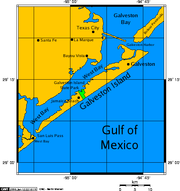
of water at the south-western end of Galveston Island
Galveston Island
Galveston Island is a barrier island on the Texas Gulf coast in the United States, about 50 miles southeast of Houston. The entire island, with the exception of Jamaica Beach, is within the city limits of the City of Galveston....
off the shores of the U.S. state
U.S. state
A U.S. state is any one of the 50 federated states of the United States of America that share sovereignty with the federal government. Because of this shared sovereignty, an American is a citizen both of the federal entity and of his or her state of domicile. Four states use the official title of...
of Texas
Texas
Texas is the second largest U.S. state by both area and population, and the largest state by area in the contiguous United States.The name, based on the Caddo word "Tejas" meaning "friends" or "allies", was applied by the Spanish to the Caddo themselves and to the region of their settlement in...
. It connects the sheltered waters of West Bay
West Bay (Texas)
West Bay, also referred to as West Galveston Bay, is a long inlet of Galveston Bay in Galveston and Brazoria counties that nearly runs the entire length west of Galveston Island.-History:...
to the open Gulf of Mexico
Gulf of Mexico
The Gulf of Mexico is a partially landlocked ocean basin largely surrounded by the North American continent and the island of Cuba. It is bounded on the northeast, north and northwest by the Gulf Coast of the United States, on the southwest and south by Mexico, and on the southeast by Cuba. In...
.
Fishing
Pier fishing on the San Luis Pass Pier was a favorite for visitors and locals alike for many years, however the beach and pier were wiped out during Hurricane Ike in 2008, and is unable to be rebuilt. The pass is also home to bank fishermen who often travel many miles to take advantage of the excellent redfish population from June thru October.Overnight camping, while once allowed, is prohibited on the Galveston side of the pass. Swimmers and fishermen have been killed in the Pass' treacherous waters, largely due to murky water, uncharted drop-offs, and fast moving currents. The San Luis Pass Camp Ground and county park http://www.brazoria-county.com/parks/San_Luis_Pass/index.asp is the only accessible place now.
Hurricane Ike in September 2008, forever changed the topography of the beach. What was once a driveway and public beach access is now part of the Gulf of Mexico. The land where the bait house of the pier once stood, is now permanently submerged.

