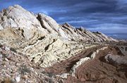
San Rafael Reef
Encyclopedia
The San Rafael Reef is a geologic feature located in Emery County
in central Utah
, part of the Colorado Plateau
. Approximately 75 miles (120 km) long, it is the name given to the distinctive eastern edge of the San Rafael Swell
. Composed primarily of steeply tilted layers
of Navajo
and Wingate
Sandstone
, it has been eroded into tall fins, domes, cliffs, and deep canyons.
The San Rafael River
, Interstate 70
, and Muddy Creek
all cut through the San Rafael Reef. There are also numerous slot canyons that twist their way through the flanks of the San Rafael Reef, among them Crack Canyon, Chute Canyon and Straight Wash. These spectacularly beautiful canyons are often less than a few feet wide and can be hundreds of feet deep. Much of the San Rafael Reef has been determined to possess wilderness characteristics and the Crack Canyon and Mexican Mountain Wilderness Study Areas, or WSAs, currently protect several thousand acres of the most worthy areas of the San Rafael Reef and are awaiting an overdue designation as BLM Wilderness by the Congress.

Emery County, Utah
Emery County is a county located in the U.S. state of Utah. As of 2000 the population was 10,860, and by 2009 had been estimated to decrease to 10,629. It was named for George W. Emery, governor of the Utah Territory in 1875...
in central Utah
Utah
Utah is a state in the Western United States. It was the 45th state to join the Union, on January 4, 1896. Approximately 80% of Utah's 2,763,885 people live along the Wasatch Front, centering on Salt Lake City. This leaves vast expanses of the state nearly uninhabited, making the population the...
, part of the Colorado Plateau
Colorado Plateau
The Colorado Plateau, also called the Colorado Plateau Province, is a physiographic region of the Intermontane Plateaus, roughly centered on the Four Corners region of the southwestern United States. The province covers an area of 337,000 km2 within western Colorado, northwestern New Mexico,...
. Approximately 75 miles (120 km) long, it is the name given to the distinctive eastern edge of the San Rafael Swell
San Rafael Swell
The San Rafael Swell is a large geologic feature located in south-central Utah, USA about 30 miles west of Green River, Utah. The San Rafael Swell, approximately by , consists of a giant dome-shaped anticline of sandstone, shale, and limestone that was pushed up during the Paleocene Laramide...
. Composed primarily of steeply tilted layers
Stratigraphy
Stratigraphy, a branch of geology, studies rock layers and layering . It is primarily used in the study of sedimentary and layered volcanic rocks....
of Navajo
Navajo Sandstone
Navajo Sandstone is a geologic formation in the Glen Canyon Group that is spread across the U.S. states of northern Arizona, northwest Colorado, and Utah; as part of the Colorado Plateau province of the United States...
and Wingate
Wingate Sandstone
Wingate Sandstone is a geologic formation in the Glen Canyon Group that is spread across the Colorado Plateau province of the United States, including northern Arizona, northwest Colorado, Nevada, and Utah. This rock formation is particularly prominent in southeastern Utah, where it forms...
Sandstone
Sandstone
Sandstone is a sedimentary rock composed mainly of sand-sized minerals or rock grains.Most sandstone is composed of quartz and/or feldspar because these are the most common minerals in the Earth's crust. Like sand, sandstone may be any colour, but the most common colours are tan, brown, yellow,...
, it has been eroded into tall fins, domes, cliffs, and deep canyons.
The San Rafael River
San Rafael River (Utah)
The San Rafael River is a tributary of the Green River, approximately long, in east central Utah in the United States. The river flows across a sparsely populated arid region of the Colorado Plateau, and is known for the isolated, scenic gorge through which it flows.It rises in northwestern...
, Interstate 70
Interstate 70
Interstate 70 is an Interstate Highway in the United States that runs from Interstate 15 near Cove Fort, Utah, to a Park and Ride near Baltimore, Maryland. It was the first Interstate Highway project in the United States. I-70 approximately traces the path of U.S. Route 40 east of the Rocky...
, and Muddy Creek
Muddy Creek (Utah)
Muddy Creek is a stream which drains portions of Emery and Wayne Counties in central Utah, in the western United States. It begins on the eastern slopes of the Wasatch Plateau at elevations above 10,500 feet . It turns southward near the town of Emery, then southeastward where it crosses under...
all cut through the San Rafael Reef. There are also numerous slot canyons that twist their way through the flanks of the San Rafael Reef, among them Crack Canyon, Chute Canyon and Straight Wash. These spectacularly beautiful canyons are often less than a few feet wide and can be hundreds of feet deep. Much of the San Rafael Reef has been determined to possess wilderness characteristics and the Crack Canyon and Mexican Mountain Wilderness Study Areas, or WSAs, currently protect several thousand acres of the most worthy areas of the San Rafael Reef and are awaiting an overdue designation as BLM Wilderness by the Congress.


