
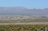
Sandy Valley, Nevada
Encyclopedia
Sandy Valley is a census-designated place
(CDP) in the Mesquite Valley in west-central Clark County
, Nevada
, United States
. Sandy Valley has variant name of Sandy, Nevada. The population was 1,804 at the 2000 census
. Sandy Valley is bordered on the East by the southern extension of the Spring Mountains and on the west by the California state line. Sandy Valley began in the 19th century as the five mining communities of Kingston, Sandy, Ripley, Mesquite, and Platina. It is roughly a forty-five mile drive from Las Vegas
.
Residents of the community have numbers in the format (702) 723-xxxx. The ZIP code for this area is 89019.
Residents of the neighboring areas of the Mesquite Valley in California have telephone numbers (760) 657-xxxx.
Sky Ranch Estates Airport
(FAA Identifier: 3L2), is the local general aviation field. The airfield is located on the Nevada side of both the Von Schmidt Line 1873 (state line) and the present-day state line. A BLM Runway runs parallel to the state line and is located between the 1873 Von Schmidt state line and the current state line. The intersection of the two runways is at 35°47′40"N 115°37′42"W. On some maps the airport is incorrectly plotted near the intersection of Kingston Road and Quartz Avenue.
According to the United States Census Bureau
, the CDP has a total area of 56 square miles (145 km²), all of it land.
of 2000, there were 1,804 people, 714 households, and 476 families residing in the CDP. The population density
was 32.2 people per square mile (12.4/km²). There were 811 housing units at an average density of 14.5 per square mile (5.6/km²). The racial makeup of the CDP was 92.57% White, 1.39% African American, 0.61% Native American, 0.72% Asian, 0.06% Pacific Islander, 2.72% from other races
, and 1.94% from two or more races. Hispanic or Latino of any race were 6.49% of the population.
There were 714 households out of which 26.2% had children under the age of 18 living with them, 54.1% were married couples
living together, 7.3% had a female householder with no husband present, and 33.2% were non-families. 23.8% of all households were made up of individuals and 7.8% had someone living alone who was 65 years of age or older. The average household size was 2.53 and the average family size was 3.03.
In the CDP the population was spread out with 25.1% under the age of 18, 4.0% from 18 to 24, 25.3% from 25 to 44, 33.8% from 45 to 64, and 11.9% who were 65 years of age or older. The median age was 43 years. For every 100 females there were 101.3 males. For every 100 females age 18 and over, there were 106.4 males.
The median income for a household in the CDP was $43,663, and the median income for a family was $46,389. Males had a median income of $37,000 versus $26,074 for females. The per capita income
for the CDP was $17,439. About 9.0% of families and 14.9% of the population were below the poverty line, including 22.7% of those under age 18 and 8.7% of those age 65 or over.
In 2007 Clark County estimated the population at 2,099 up from 1,974 in 2006
serves Sandy Valley.
Residents are zoned to Sandy Valley School (K-12).
Census-designated place
A census-designated place is a concentration of population identified by the United States Census Bureau for statistical purposes. CDPs are delineated for each decennial census as the statistical counterparts of incorporated places such as cities, towns and villages...
(CDP) in the Mesquite Valley in west-central Clark County
Clark County, Nevada
-Demographics:As of the census of 2000, there were 1,375,765 people, 512,253 households, and 339,693 families residing within the MSA. The racial makeup of the MSA was 71.6% White , 9.1% Black, 5.7% Asian, 0.8% American Indian and 12.8% of other or mixed race. 22.0% were Hispanic of any race...
, Nevada
Nevada
Nevada is a state in the western, mountain west, and southwestern regions of the United States. With an area of and a population of about 2.7 million, it is the 7th-largest and 35th-most populous state. Over two-thirds of Nevada's people live in the Las Vegas metropolitan area, which contains its...
, United States
United States
The United States of America is a federal constitutional republic comprising fifty states and a federal district...
. Sandy Valley has variant name of Sandy, Nevada. The population was 1,804 at the 2000 census
United States Census, 2000
The Twenty-second United States Census, known as Census 2000 and conducted by the Census Bureau, determined the resident population of the United States on April 1, 2000, to be 281,421,906, an increase of 13.2% over the 248,709,873 persons enumerated during the 1990 Census...
. Sandy Valley is bordered on the East by the southern extension of the Spring Mountains and on the west by the California state line. Sandy Valley began in the 19th century as the five mining communities of Kingston, Sandy, Ripley, Mesquite, and Platina. It is roughly a forty-five mile drive from Las Vegas
Las Vegas, Nevada
Las Vegas is the most populous city in the U.S. state of Nevada and is also the county seat of Clark County, Nevada. Las Vegas is an internationally renowned major resort city for gambling, shopping, and fine dining. The city bills itself as The Entertainment Capital of the World, and is famous...
.
Residents of the community have numbers in the format (702) 723-xxxx. The ZIP code for this area is 89019.
Residents of the neighboring areas of the Mesquite Valley in California have telephone numbers (760) 657-xxxx.
Sky Ranch Estates Airport
Sky Ranch Airport (Nevada)
Sky Ranch Airport , also known as Sky Ranch Estates, is a privately-owned, public-use airport located two miles southwest of the central business district of Sandy Valley, a town in Clark County, Nevada, United States....
(FAA Identifier: 3L2), is the local general aviation field. The airfield is located on the Nevada side of both the Von Schmidt Line 1873 (state line) and the present-day state line. A BLM Runway runs parallel to the state line and is located between the 1873 Von Schmidt state line and the current state line. The intersection of the two runways is at 35°47′40"N 115°37′42"W. On some maps the airport is incorrectly plotted near the intersection of Kingston Road and Quartz Avenue.
Geography
Sandy Valley is located at 35°49′44"N 115°39′7"W (35.828999, -115.651943).According to the United States Census Bureau
United States Census Bureau
The United States Census Bureau is the government agency that is responsible for the United States Census. It also gathers other national demographic and economic data...
, the CDP has a total area of 56 square miles (145 km²), all of it land.
Demographics
As of the censusCensus
A census is the procedure of systematically acquiring and recording information about the members of a given population. It is a regularly occurring and official count of a particular population. The term is used mostly in connection with national population and housing censuses; other common...
of 2000, there were 1,804 people, 714 households, and 476 families residing in the CDP. The population density
Population density
Population density is a measurement of population per unit area or unit volume. It is frequently applied to living organisms, and particularly to humans...
was 32.2 people per square mile (12.4/km²). There were 811 housing units at an average density of 14.5 per square mile (5.6/km²). The racial makeup of the CDP was 92.57% White, 1.39% African American, 0.61% Native American, 0.72% Asian, 0.06% Pacific Islander, 2.72% from other races
Race (United States Census)
Race and ethnicity in the United States Census, as defined by the Federal Office of Management and Budget and the United States Census Bureau, are self-identification data items in which residents choose the race or races with which they most closely identify, and indicate whether or not they are...
, and 1.94% from two or more races. Hispanic or Latino of any race were 6.49% of the population.
There were 714 households out of which 26.2% had children under the age of 18 living with them, 54.1% were married couples
Marriage
Marriage is a social union or legal contract between people that creates kinship. It is an institution in which interpersonal relationships, usually intimate and sexual, are acknowledged in a variety of ways, depending on the culture or subculture in which it is found...
living together, 7.3% had a female householder with no husband present, and 33.2% were non-families. 23.8% of all households were made up of individuals and 7.8% had someone living alone who was 65 years of age or older. The average household size was 2.53 and the average family size was 3.03.
In the CDP the population was spread out with 25.1% under the age of 18, 4.0% from 18 to 24, 25.3% from 25 to 44, 33.8% from 45 to 64, and 11.9% who were 65 years of age or older. The median age was 43 years. For every 100 females there were 101.3 males. For every 100 females age 18 and over, there were 106.4 males.
The median income for a household in the CDP was $43,663, and the median income for a family was $46,389. Males had a median income of $37,000 versus $26,074 for females. The per capita income
Per capita income
Per capita income or income per person is a measure of mean income within an economic aggregate, such as a country or city. It is calculated by taking a measure of all sources of income in the aggregate and dividing it by the total population...
for the CDP was $17,439. About 9.0% of families and 14.9% of the population were below the poverty line, including 22.7% of those under age 18 and 8.7% of those age 65 or over.
In 2007 Clark County estimated the population at 2,099 up from 1,974 in 2006
Education
Clark County School DistrictClark County School District
The Clark County School District, , is the 5th largest school district in the United States. It serves all of Clark County, Nevada, including the cities of Las Vegas, Henderson, North Las Vegas, Boulder City, and Mesquite; plus the census-designated places of Laughlin, Blue Diamond, Logandale,...
serves Sandy Valley.
Residents are zoned to Sandy Valley School (K-12).