

Sarcee Trail
Encyclopedia
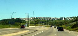
Sarcee Trail is a major urban arterial road in Calgary
, Alberta
. It is divided into two portions, one in the north end of the city, and one in the south end of the city. Originally planned as one continuous route, plans to connect the two halves have been shelved. The road is named for the Tsuu T'ina, who were also known as the Sarcee.
in the north and Silver Springs in the south. It starts at the intersection of Crowchild Trail
and Silver Springs Gate, a short road linking Sarcee Trail to the Silver Springs community after plans to connect the two halves of Sarcee Trail fell through. Heading northbounds, Sarcee Trail terminates at Sherwood Boulevard in the north, acting as the divider between several communities along the way.
 The southern half of Sarcee Trail acts as a major connector between Glenmore Trail to the south and 16 Avenue North in the west end of the city, though the road continues north into the community of Bowness at 34 Avenue. Sarcee Trail crosses the divide between the north and south halves of the city just before reaching Bowdale Crescent, a short service road.
Calgary
Calgary is a city in the Province of Alberta, Canada. It is located in the south of the province, in an area of foothills and prairie, approximately east of the front ranges of the Canadian Rockies...
, Alberta
Alberta
Alberta is a province of Canada. It had an estimated population of 3.7 million in 2010 making it the most populous of Canada's three prairie provinces...
. It is divided into two portions, one in the north end of the city, and one in the south end of the city. Originally planned as one continuous route, plans to connect the two halves have been shelved. The road is named for the Tsuu T'ina, who were also known as the Sarcee.
Sarcee Trail North
The northern half of Sarcee Trail travels between the communities of SherwoodSherwood, Calgary
Sherwood is a residential neighbourhood in the north-west quadrant of Calgary, Alberta. It is located at the North edge of the city, and is bounded to the East by Kincora, Calgary, to the South by Hamptons, Calgary, and to the West by Sarcee Trail...
in the north and Silver Springs in the south. It starts at the intersection of Crowchild Trail
Crowchild Trail
Crowchild Trail is an expressway located on the west side of Calgary, Alberta, Canada.The road was originally signed as 24th Street SW from North Glenmore Park to the Bow River, 24th Street NW from the Bow to the intersection with 16th Avenue NW , and Highway 1A from 16th Ave NW to the city limits...
and Silver Springs Gate, a short road linking Sarcee Trail to the Silver Springs community after plans to connect the two halves of Sarcee Trail fell through. Heading northbounds, Sarcee Trail terminates at Sherwood Boulevard in the north, acting as the divider between several communities along the way.
| km | Intersection | Notes |
|---|---|---|
| 0 | Crowchild Trail Crowchild Trail Crowchild Trail is an expressway located on the west side of Calgary, Alberta, Canada.The road was originally signed as 24th Street SW from North Glenmore Park to the Bow River, 24th Street NW from the Bow to the intersection with 16th Avenue NW , and Highway 1A from 16th Ave NW to the city limits... (Alberta Highway 1A) |
Continues southbound as Silver Springs Gate |
| John Laurie Boulevard John Laurie Boulevard John Laurie Boulevard is a major arterial road in the northwestern quadrant Calgary, Alberta. It extends from the community of Arbour Lake in the west to North Haven in the east, where the road meets with 48 Avenue NW and continues eastbound as McKnight Boulevard... |
||
| Country Hills Boulevard Country Hills Boulevard Country Hills Boulevard is a major arterial road in Calgary, Alberta. It is notably one of the few routes north of 16 Avenue N that is mostly continuous from the west end of the city to the east end. East of Calgary, Country Hills Boulevard continues as Alberta Highway 564... |
||
| Citadel Boulevard / Citadel Green | ||
| Stoney Trail (Alberta Highway 201) | ||
| 112 Avenue NW | ||
| Sherwood Boulevard |
Sarcee Trail South
| km | Intersection | Notes |
|---|---|---|
| 0 | Glenmore Trail (Alberta Highway 8) | |
| Richmond Road | ||
| Signal Hill Centre | Southbound entrance and exit only. | |
| 17 Avenue SW | ||
| Bow Trail Bow Trail Bow Trail is a major road in the southwest quadrant of Calgary, Alberta, Canada. It lends its name from the Bow River, which runs through the city north of the road itself... |
||
| Bowdale Crescent | ||
| 16 Avenue NW (Trans-Canada Highway Trans-Canada Highway The Trans-Canada Highway is a federal-provincial highway system that joins the ten provinces of Canada. It is, along with the Trans-Siberian Highway and Australia's Highway 1, one of the world's longest national highways, with the main route spanning 8,030 km... ) |
||
| 34 Avenue NW |