Schwalm-Eder-Kreis
Encyclopedia
Schwalm-Eder is a Kreis (district
) in the north of Hesse
, Germany
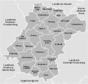
. Neighboring districts are Kassel
, Werra-Meißner, Hersfeld-Rotenburg
, Vogelsbergkreis
, Marburg-Biedenkopf
, Waldeck-Frankenberg
.
, Homberg, Melsungen and Ziegenhain. In 1932 the districts Fritzlar and Homberg were merged; in 1974 the three districts Fritzlar-Homberg, Melsungen and Ziegenhain were merged into the Schwalm-Eder district.
The district has partnership with the Finnish
city Kajaani
, the British
district Sedgemoor
, the Polish
district Pila and the Rayon Rostov (Yaroslavl Oblast
) in Russia
.
and Eder
gave the district its name. After they merge near Felsberg the Eder enters the Fulda
at the north of district. In the southeast of the district are the hills of the Knüll, with the highest elevation being 634 m. North of it are the hills of the Homberger Hochland. The center of the district is largely rural, and is surrounded by the mountains of the Knüll, the Stölzinger Gebirge and the Kellerwald
with the 675 meter-high Wüstegarten mountain.

District
Districts are a type of administrative division, in some countries managed by a local government. They vary greatly in size, spanning entire regions or counties, several municipalities, or subdivisions of municipalities.-Austria:...
) in the north of Hesse
Hesse
Hesse or Hessia is both a cultural region of Germany and the name of an individual German state.* The cultural region of Hesse includes both the State of Hesse and the area known as Rhenish Hesse in the neighbouring Rhineland-Palatinate state...
, Germany
Germany
Germany , officially the Federal Republic of Germany , is a federal parliamentary republic in Europe. The country consists of 16 states while the capital and largest city is Berlin. Germany covers an area of 357,021 km2 and has a largely temperate seasonal climate...
. Neighboring districts are Kassel
Kassel (district)
Kassel is a Kreis in the north of Hesse, Germany. Neighboring districts are Northeim, Göttingen, Werra-Meißner, Schwalm-Eder, Waldeck-Frankenberg, Höxter...
, Werra-Meißner, Hersfeld-Rotenburg
Hersfeld-Rotenburg
Hersfeld-Rotenburg is a Kreis in the east of Hesse, Germany. Neighboring districts are Werra-Meißner, Wartburgkreis, Fulda, Vogelsbergkreis, Schwalm-Eder.-History:...
, Vogelsbergkreis
Vogelsbergkreis
The Vogelsbergkreis is a Kreis in the middle of Hesse, Germany. Neighbouring districts are Schwalm-Eder, Hersfeld-Rotenburg, Fulda, Main-Kinzig, Wetteraukreis, Gießen and Marburg-Biedenkopf.-Geography:...
, Marburg-Biedenkopf
Marburg-Biedenkopf
Marburg-Biedenkopf is a Kreis in the west of Hesse, Germany. Neighboring districts are Waldeck-Frankenberg, Schwalm-Eder, Vogelsbergkreis, Gießen, Lahn-Dill, Siegen-Wittgenstein.- History :...
, Waldeck-Frankenberg
Waldeck-Frankenberg
Waldeck-Frankenberg is a Kreis in the north of Hesse, Germany. Neighbouring districts are Höxter, Kassel, Schwalm-Eder, Marburg-Biedenkopf, Siegen-Wittgenstein, Hochsauerland.-History:...
.
History
In 1821 districts were created in Hessen, including the districts FritzlarFritzlar
Fritzlar is a small German town in the Schwalm-Eder district in northern Hesse, north of Frankfurt, with a storied history. It can reasonably be argued that the town is the site where the Christianization of northern Germany began and the birthplace of the German empire as a political entity.The...
, Homberg, Melsungen and Ziegenhain. In 1932 the districts Fritzlar and Homberg were merged; in 1974 the three districts Fritzlar-Homberg, Melsungen and Ziegenhain were merged into the Schwalm-Eder district.
The district has partnership with the Finnish
Finland
Finland , officially the Republic of Finland, is a Nordic country situated in the Fennoscandian region of Northern Europe. It is bordered by Sweden in the west, Norway in the north and Russia in the east, while Estonia lies to its south across the Gulf of Finland.Around 5.4 million people reside...
city Kajaani
Kajaani
Kajaani is a town and municipality in Finland.It is the capital of the Kainuu region. It is located southeast of Oulujärvi , which drains to the Gulf of Bothnia along the Oulujoki . There are inhabitants and city surface area is of which is water. The population density is . The town is...
, the British
United Kingdom
The United Kingdom of Great Britain and Northern IrelandIn the United Kingdom and Dependencies, other languages have been officially recognised as legitimate autochthonous languages under the European Charter for Regional or Minority Languages...
district Sedgemoor
Sedgemoor
Sedgemoor is a low lying area of land in Somerset, England. It lies close to sea level south of the Polden Hills, historically largely marsh . The eastern part is known as King's Sedgemoor, and the western part West Sedgemoor. Sedgemoor is part of the area now known as the Somerset Levels...
, the Polish
Poland
Poland , officially the Republic of Poland , is a country in Central Europe bordered by Germany to the west; the Czech Republic and Slovakia to the south; Ukraine, Belarus and Lithuania to the east; and the Baltic Sea and Kaliningrad Oblast, a Russian exclave, to the north...
district Pila and the Rayon Rostov (Yaroslavl Oblast
Yaroslavl Oblast
Yaroslavl Oblast is a federal subject of Russia , which is located in the Central Federal District, surrounded by Tver, Moscow, Ivanovo, Vladimir, Kostroma, and Vologda Oblasts. This geographic location affords the oblast the advantages of proximity to Moscow and St. Petersburg...
) in Russia
Russia
Russia or , officially known as both Russia and the Russian Federation , is a country in northern Eurasia. It is a federal semi-presidential republic, comprising 83 federal subjects...
.
Geography
The two rivers SchwalmSchwalm
The Schwalm is a river in Hesse, Germany, right tributary of the Eder. It rises on the north side of the Vogelsberg Mountains. It flows north through Alsfeld, Schwalmstadt and Borken...
and Eder
Eder
The Eder is a 177 km long river in Germany, and a tributary of the Fulda River. It was first mentioned by the Roman historian Tacitus as the Adrana in the territory of the Chatti....
gave the district its name. After they merge near Felsberg the Eder enters the Fulda
Fulda
Fulda is a city in Hesse, Germany; it is located on the river Fulda and is the administrative seat of the Fulda district .- Early Middle Ages :...
at the north of district. In the southeast of the district are the hills of the Knüll, with the highest elevation being 634 m. North of it are the hills of the Homberger Hochland. The center of the district is largely rural, and is surrounded by the mountains of the Knüll, the Stölzinger Gebirge and the Kellerwald
Kellerwald
The Kellerwald is a low mountain range reaching heights of up to 675 m in the western part of northern Hesse, Germany.Its assets include Germany's largest contiguous beech woodland and it contains Hesse's only national park, the Kellerwald-Edersee National Park.- Geography :The Kellerwald lies in...
with the 675 meter-high Wüstegarten mountain.
Coat of arms
 |
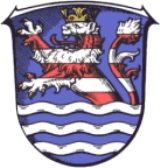
The coat of arms shows the lion of Hesse Hesse Hesse or Hessia is both a cultural region of Germany and the name of an individual German state.* The cultural region of Hesse includes both the State of Hesse and the area known as Rhenish Hesse in the neighbouring Rhineland-Palatinate state... in the top. Below are wavy lines which symbolize the three main rivers in the district, Schwalm, Eder and Fulda. |
Towns and municipalities

| Towns | Municipalities | |
|---|---|---|
|
Bad Zwesten -Location:Bad Zwesten lies about 8 km southeast of Bad Wildungen on the river Schwalm, which belongs to the Eder watershed. North of the community begins the Kellerwald-Edersee Nature Park.-Constituent communities:* Betzigerode* Niederurff... Edermünde Edermünde is a community in northern Hesse, Germany.-Location:Edermünde lies in the north of the Schwalm-Eder district not far southwest of Kassel. This is where the river Eder empties into the river Fulda... Frielendorf -Location:The state-recognized climatic spa of Frielendorf lies 9 km southwest of Homberg on the edge of the Knüllgebirge .-Constituent communities:... Gilserberg -Location:Gilserberg lies at the foot of the Kellerwald, a low mountain range, nestled in the Kurhessen Highland on Federal Highway B 3, 60 km from Kassel and 30 km from Marburg.-Constituent communities:... Guxhagen Guxhagen is a community in Schwalm-Eder district in northern Hesse, Germany.-Geography:Guxhagen lies about 15 km south of Kassel between the Habichtswald Nature Park and the Meißner-Kaufunger Wald Nature Park on the river Fulda. It neighbors Edermünde, Felsberg, Fuldabrück and Körle... Jesberg -Location:Jesberg lies from 210 to 675 m high in the Gilsa river valley eastsoutheast of the Wüstegarten, which at 675 m above sea level is both the Kellerwald range's and the Schwalm-Eder district's highest peak... Knüllwald -Location:Knüllwald lies in the Knüllgebirge, a low mountain range, between the rivers Efze and Beise, south of Kassel.-Constituent communities:The community consists of sixteen centres: Appenfeld, Berndshausen, Ellingshausen, Hausen, Hergetsfeld, Lichtenhagen, Nausis, Nenterode, Niederbeisheim,... Körle Körle is a community in the Schwalm-Eder district in Hesse, Germany. It lies about 20 km south of Kassel near the turn-off for Guxhagen on Autobahn A 7.-History:Körle was first mentioned in 1074 in a donation document from the Fulda monastery.... Malsfeld Malsfeld is a community in the Schwalm-Eder district in Hesse, Germany, on the river Fulda.The community consists of the centres of Beiseförth, Dagobertshausen, Elfershausen, Mosheim, Malsfeld, Ostheim and Sipperhausen.... |
|
External links
- Official website (German)

