
Sevier Lake
Encyclopedia
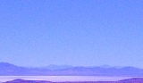
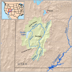
Sevier Lake is an intermittent and endorheic
lake which lies in the lowest part of the Sevier Desert, Millard County, Utah
. Like Great Salt Lake
and Utah Lake
, it is a remnant of Pleistocene
Lake Bonneville
. Sevier Lake is fed primarily by the Beaver and Sevier
rivers, and the additional inflow is from the lakes watershed that is part of the Escalante-Sevier hydrologic subregion. The lake has been mostly dry throughout recorded history and is a source of wind-blown dust in dust storm
s that frequently sweep the Wasatch Front
.
The Dominguez-Escalante Expedition
named it "Laguna de Miera" after a cartographer on their 1776 expedition. In 1825, trappers working for William Henry Ashley
trapped the region, and Jedediah Smith
named it after him, the Ashley Lake. On some maps, it was named after Joseph Nicollet
in the mid-19th century. The lake is currently named for the river, which is derived from "Rio Severo" (wild river), a local name given by early Spanish
explorers.
Endorheic
An endorheic basin is a closed drainage basin that retains water and allows no outflow to other bodies of water such as rivers or oceans...
lake which lies in the lowest part of the Sevier Desert, Millard County, Utah
Millard County, Utah
Millard County is a county located in the U.S. state of Utah. In 2010, its population was 12,420. It was named for Millard Fillmore, thirteenth President of the United States. Its county seat is Fillmore and the largest city is Delta.-Geography:...
. Like Great Salt Lake
Great Salt Lake
The Great Salt Lake, located in the northern part of the U.S. state of Utah, is the largest salt water lake in the western hemisphere, the fourth-largest terminal lake in the world. In an average year the lake covers an area of around , but the lake's size fluctuates substantially due to its...
and Utah Lake
Utah Lake
Utah Lake is a freshwater lake in the U.S. state of Utah. On the western side of Utah Valley, the lake is overlooked by Mount Timpanogos and Mount Nebo. The lake's only river outlet, the Jordan River, is a tributary of the Great Salt Lake and is highly regulated with pumps. Evaporation accounts...
, it is a remnant of Pleistocene
Pleistocene
The Pleistocene is the epoch from 2,588,000 to 11,700 years BP that spans the world's recent period of repeated glaciations. The name pleistocene is derived from the Greek and ....
Lake Bonneville
Lake Bonneville
Lake Bonneville was a prehistoric pluvial lake that covered much of North America's Great Basin region. Most of the territory it covered was in present-day Utah, though parts of the lake extended into present-day Idaho and Nevada. Formed about 32,000 years ago, it existed until about 14,500 years...
. Sevier Lake is fed primarily by the Beaver and Sevier
Sevier River
The Sevier River , extending , is the longest Utah river entirely in the state and drains an extended chain of mountain farming valleys to the intermittent Sevier Lake...
rivers, and the additional inflow is from the lakes watershed that is part of the Escalante-Sevier hydrologic subregion. The lake has been mostly dry throughout recorded history and is a source of wind-blown dust in dust storm
Dust storm
A dust / sand storm is a meteorological phenomenon common in arid and semi-arid regions. Dust storms arise when a gust front or other strong wind blows loose sand and dirt from a dry surface. Particles are transported by saltation and suspension, causing soil to move from one place and deposition...
s that frequently sweep the Wasatch Front
Wasatch Front
The Wasatch Front is a metropolitan region in the north-central part of the U.S. state of Utah. It consists of a chain of cities and towns stretched along the Wasatch Range from approximately Santaquin in the south to Brigham City in the north...
.
History
The first recorded observation was in 1872, which stated that the lake's surface area was 188 square miles (486.9 km²), salinity was measured at 86 parts per thousand, two and a half times that of the ocean, and maximum depth was 15 feet (4.6 m). In January 1880 the lake was nearly dry, and had been so for the past one or two years. The Sevier River which once flowed to the lake is now largely diverted for irrigation. In 1987 however, the lake was again similar to the recorded description of 1872.The Dominguez-Escalante Expedition
Dominguez-Escalante Expedition
The Dominguez-Escalante Expedition was conducted in 1776 to find an overland route from Santa Fe, New Mexico to Spanish missions in California...
named it "Laguna de Miera" after a cartographer on their 1776 expedition. In 1825, trappers working for William Henry Ashley
William Henry Ashley
William Henry Ashley was a pioneering fur trader, entrepreneur, and politician. Though a native of Virginia, Ashley had already moved to St. Genevieve in what was then called Louisiana, when it was purchased by the United States from France in 1803...
trapped the region, and Jedediah Smith
Jedediah Smith
Jedediah Strong Smith was a hunter, trapper, fur trader, trailblazer, author, cartographer, cattleman, and explorer of the Rocky Mountains, the American West Coast and the Southwest during the 19th century...
named it after him, the Ashley Lake. On some maps, it was named after Joseph Nicollet
Joseph Nicollet
Joseph Nicolas Nicollet , also known as Jean-Nicolas Nicollet, was a French geographer and mathematician known for mapping the Upper Mississippi River basin during the 1830s....
in the mid-19th century. The lake is currently named for the river, which is derived from "Rio Severo" (wild river), a local name given by early Spanish
Spanish language
Spanish , also known as Castilian , is a Romance language in the Ibero-Romance group that evolved from several languages and dialects in central-northern Iberia around the 9th century and gradually spread with the expansion of the Kingdom of Castile into central and southern Iberia during the...
explorers.