Shawmut Peninsula
Encyclopedia


Promontory
Promontory may refer to:*Promontory, a prominent mass of land which overlooks lower lying land or a body of water*Promontory, Utah, the location where the United States first Transcontinental Railroad was completed...
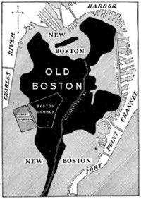
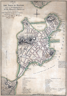
of land on which Boston, Massachusetts was built. The peninsula
Peninsula
A peninsula is a piece of land that is bordered by water on three sides but connected to mainland. In many Germanic and Celtic languages and also in Baltic, Slavic and Hungarian, peninsulas are called "half-islands"....
, originally a mere 789 acres (3.2 km²) in area, more than doubled in size due to land reclamation
Land reclamation
Land reclamation, usually known as reclamation, is the process to create new land from sea or riverbeds. The land reclaimed is known as reclamation ground or landfill.- Habitation :...
efforts, a feature of the history of Boston throughout the 19th century.
Geology and original topography
Like much of the MassachusettsMassachusetts
The Commonwealth of Massachusetts is a state in the New England region of the northeastern United States of America. It is bordered by Rhode Island and Connecticut to the south, New York to the west, and Vermont and New Hampshire to the north; at its east lies the Atlantic Ocean. As of the 2010...
landscape, the peninsula was shaped by glacial erosion and moraine deposits left by retreating glaciers at the end of the last ice age
Ice age
An ice age or, more precisely, glacial age, is a generic geological period of long-term reduction in the temperature of the Earth's surface and atmosphere, resulting in the presence or expansion of continental ice sheets, polar ice sheets and alpine glaciers...
. When Europeans arrived, Shawmut was thickly forested. The pre-settlement topography of the peninsula was marked by three hills: Copps Hill, in what is now the North End
North End, Boston, Massachusetts
The North End is a neighborhood of Boston, Massachusetts. It has the distinction of being the city's oldest residential community, where people have lived continuously since it was settled in the 1630s. Though small , the neighborhood has approximately 100 eating establishments, and a variety of...
; Fort Hill, in today's Financial District
Financial District, Boston, Massachusetts
The Financial District of Boston, Massachusetts, United States is located in the downtown area near Government Center and Chinatown.Like many areas within Boston, the Financial District has no official definition. It is roughly bounded by Atlantic Avenue, State Street, and Devonshire Street...
; and the Trimountain, today's Beacon Hill
Beacon Hill, Boston, Massachusetts
Beacon Hill is a historic neighborhood of Boston, Massachusetts, that along with the neighboring Back Bay is home to about 26,000 people. It is a neighborhood of Federal-style rowhouses and is known for its narrow, gas-lit streets and brick sidewalks...
district. Of the three hills, the Trimountain was by far the largest, a steep-sided mass with three summits. Its name was eventually shortened to Tremont. To the south was a narrow isthmus
Isthmus
An isthmus is a narrow strip of land connecting two larger land areas usually with waterforms on either side.Canals are often built through isthmuses where they may be particularly advantageous to create a shortcut for marine transportation...
named Boston Neck
Boston Neck
The Boston Neck or Roxbury Neck was an isthmus, a narrow strip of land connecting the then-peninsular city of Boston to the mainland city of Roxbury . The surrounding area was gradually filled in as the city of Boston expanded in population. -History:The Boston Neck was originally about wide at...
that connected the peninsula to the mainland site of Roxbury, now a neighborhood of Boston.
English settlement
The name is derived from MashauwomukShawmut
Shawmut, according to 19th century scholarship, is a term derived from the Algonquian word Mashauwomuk referring to the region of present day Boston, Massachusetts.University Press, 1886...
, an Algonquian
Algonquian languages
The Algonquian languages also Algonkian) are a subfamily of Native American languages which includes most of the languages in the Algic language family. The name of the Algonquian language family is distinguished from the orthographically similar Algonquin dialect of the Ojibwe language, which is a...
word of uncertain meaning. The first recorded use of "Shawmutt" to describe the peninsula occurs in 1630, by the lone settler William Blackstone
William Blaxton
Reverend William Blaxton was an early British settler in New England, and the first European settler of modern day Boston and Rhode Island.-Biography:...
, in an invitation to John Winthrop
John Winthrop
John Winthrop was a wealthy English Puritan lawyer, and one of the leading figures in the founding of the Massachusetts Bay Colony, the first major settlement in New England after Plymouth Colony. Winthrop led the first large wave of migrants from England in 1630, and served as governor for 12 of...
to move the site of Winthrop's colonial settlement to the peninsula from what is now Charlestown
Charlestown, Massachusetts
Charlestown is a neighborhood of Boston, Massachusetts, United States, and is located on a peninsula north of downtown Boston. Charlestown was originally a separate town and the first capital of the Massachusetts Bay Colony; it became a city in 1847 and was annexed by Boston on January 5, 1874...
. The Charlestown peninsula lacked a source of fresh water, while the Shawmut peninsula had an "excellent spring" on the north side of what is now Beacon Hill
Beacon Hill, Boston, Massachusetts
Beacon Hill is a historic neighborhood of Boston, Massachusetts, that along with the neighboring Back Bay is home to about 26,000 people. It is a neighborhood of Federal-style rowhouses and is known for its narrow, gas-lit streets and brick sidewalks...
.
Land reclamation
Reclamation projects began in 1820 and continued intermittently until 1900 and created the Boston neighborhoods of the South End, Back Bay, and Fenway-KenmoreFenway-Kenmore
Fenway–Kenmore is an official neighborhood of Boston, Massachusetts. While it is considered one neighborhood for administrative purposes, it is composed of numerous distinct sections and in casual conversation are almost always referred to as "Fenway," "Kenmore Square," or "Kenmore."...
. The Back Bay Fens
Back Bay Fens
The Back Bay Fens, most commonly called simply The Fens, is a parkland and urban wild in Boston, Massachusetts, in the United States.Designed by Frederick Law Olmsted to serve as a link in the Emerald Necklace park system, the Fens gives its name to the Fenway-Kenmore neighborhood, and thereby to...
, a freshwater
Freshwater
Fresh water is naturally occurring water on the Earth's surface in ice sheets, ice caps, glaciers, bogs, ponds, lakes, rivers and streams, and underground as groundwater in aquifers and underground streams. Fresh water is generally characterized by having low concentrations of dissolved salts and...
urban wild
Urban wild
An urban wild is a remnant of a natural ecosystem found in the midst of an otherwise highly developed urban area.-Utility:Urban wilds, particularly those of several acres or more, are often intact ecological systems that can provide essential ecosystem functions such as the filtering of urban...
in the latter area, is a remnant of the salt marsh
Salt marsh
A salt marsh is an environment in the upper coastal intertidal zone between land and salt water or brackish water, it is dominated by dense stands of halophytic plants such as herbs, grasses, or low shrubs. These plants are terrestrial in origin and are essential to the stability of the salt marsh...
es that once surrounded Shawmut Peninsula.
Although this project eliminated the wetland
Wetland
A wetland is an area of land whose soil is saturated with water either permanently or seasonally. Wetlands are categorised by their characteristic vegetation, which is adapted to these unique soil conditions....
ecosystem
Ecosystem
An ecosystem is a biological environment consisting of all the organisms living in a particular area, as well as all the nonliving , physical components of the environment with which the organisms interact, such as air, soil, water and sunlight....
that existed there at the time and would be impossible under modern environmental regulations, it was considered a great boon to the community for two reasons. Firstly, it eliminated the foul-smelling tidal flats that had become polluted
Pollution
Pollution is the introduction of contaminants into a natural environment that causes instability, disorder, harm or discomfort to the ecosystem i.e. physical systems or living organisms. Pollution can take the form of chemical substances or energy, such as noise, heat or light...
with sewage
Sewage
Sewage is water-carried waste, in solution or suspension, that is intended to be removed from a community. Also known as wastewater, it is more than 99% water and is characterized by volume or rate of flow, physical condition, chemical constituents and the bacteriological organisms that it contains...
. Secondly, it created what is now some of the most valuable real estate in New England
New England
New England is a region in the northeastern corner of the United States consisting of the six states of Maine, New Hampshire, Vermont, Massachusetts, Rhode Island, and Connecticut...
.

