Shell Creek
Encyclopedia


Bighorn River
The Bighorn River is a tributary of the Yellowstone, approximately long, in the western United States in the states of Wyoming and Montana. The river was named in 1805 by fur trader François Larocque for the Bighorn Sheep he saw along its banks as he explored the Yellowstone River.The upper...
, approximately 50 mi (50 km) long, in Wyoming
Wyoming
Wyoming is a state in the mountain region of the Western United States. The western two thirds of the state is covered mostly with the mountain ranges and rangelands in the foothills of the Eastern Rocky Mountains, while the eastern third of the state is high elevation prairie known as the High...
in the United States
United States
The United States of America is a federal constitutional republic comprising fifty states and a federal district...
. Lying entirely within Big Horn County, Shell Creek begins above the Shell Lakes in the Bighorn Mountains. Starting at an elevation of over 11,000 ft (17700 m), it drops to below 3800 ft (6100 m) as it descends the western side of the Bighorn Mountains through Shell Canyon and enters the Big Horn Basin near Shell, Wyoming
Shell, Wyoming
Shell is an unincorporated community in Big Horn County, Wyoming, United States.The community is named for the abundance of fossil shells located in the area. Nearby exposed formations such as the Cloverly Formation and the Morrison Formation have yielded numerous fossils of dinosaurs and other...
. It flows into the Bighorn River
Bighorn River
The Bighorn River is a tributary of the Yellowstone, approximately long, in the western United States in the states of Wyoming and Montana. The river was named in 1805 by fur trader François Larocque for the Bighorn Sheep he saw along its banks as he explored the Yellowstone River.The upper...
, a tributary
Tributary
A tributary or affluent is a stream or river that flows into a main stem river or a lake. A tributary does not flow directly into a sea or ocean...
of the Yellowstone River
Yellowstone River
The Yellowstone River is a tributary of the Missouri River, approximately long, in the western United States. Considered the principal tributary of the upper Missouri, the river and its tributaries drain a wide area stretching from the Rocky Mountains in the vicinity of the Yellowstone National...
, just north of Greybull
Greybull, Wyoming
Greybull is a town in Big Horn County, Wyoming, United States. The population was 1,815 at the 2000 census.-Geography:Greybull is located at ....
.
Watershed
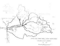
The Shell Creek watershed consists 370,500 acres of native rangeland (73%), forest (24%), irrigated cropland, pasture and hayland (3%). There are over 10500 acres (42.5 km²) of irrigated lands in the Shell Creek watershed; the greater part (92%) of which is in the lower portion-downstream from the town of ShellShell, Wyoming
Shell is an unincorporated community in Big Horn County, Wyoming, United States.The community is named for the abundance of fossil shells located in the area. Nearby exposed formations such as the Cloverly Formation and the Morrison Formation have yielded numerous fossils of dinosaurs and other...
. About 7500 acres (30.4 km²) are irrigated from Shell Creek itself. Also, the part of the creek is diverted above Shell and conveyed via pipeline to the town of Greybull as a municipal water supply.
Transportation
US 14U.S. Route 14
U.S. Route 14 , an east–west route, is one of the original United States highways of 1926. It currently has a length of 1,398 miles , but it had a peak length of 1,429 miles . For much of its length, it runs roughly parallel to Interstate 90.As of 2004, the highway's eastern terminus is in...
, the Bighorn Scenic Byway, travels along Shell Creek through the canyon. This modern highway is relatively young. Much of it was completed in the mid-1960's, with major improvements in the 1980's.

