
Sheskin
Encyclopedia
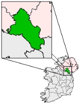
Sheskin traditionally written Sheskinmore, is a townland
in the north of County Monaghan
in Republic of Ireland
. It is in the foothills
of Sliabh Beagh
. Sheskin is part of the Parish
of Tydavnet
, situated about 3 miles from the village of Scotstown
and about 8 miles from Monaghan
town. Sheskin is straddled in the east by the River Blackwater
and in the south by one of its tributaries, which converge at the south eastern corner of the townland.
Other townlands and places in Ireland have the same name, or similar derivatives. The name derives from the Irish Gaelic word for marsh
, and refers to the significant area of blanket bog
within the townland.
. In the 17th century, as the Ulster Plantation got underway, Sheskin and the other uplands were common land
s for the lower lying districts around Scotstown, and so would have been cleared, but have remained fairly open. In the 18th century, land would have started to be allocated to tenants, and so the process of enclosing parcels into fields would have begun.
Sheskin is one of the larger townlands of the Parish of Tydavnet, which reflects the poorer land quality. Sheskin would have been classified as a townland during the Ulster Plantation in the 17th century, and probably would have been assigned from a previously existing tate
of the same geographic area and name. Tate was a local term for an area of land, used in Monaghan
, which was typically smaller than ploughlands
which were used elsewhere, and so resulted in smaller townlands on average than in other counties.
It is understood that Sheskin is the location where Potato blight was first identified in Monaghan, in the Autumn of 1845, the disease that ultimately led to the Irish Famine. This event is now commemorated by the famine stone located at the bottom of the Black Hill, in the south east of the townland. In Monaghan alone anywhere from 20-30% of the population would ultimately die during the famine. Although the upland districts of the north were not as badly hit as the south of county Monaghan, the Parish of Tydavent did have a population of 11600 in 1841, and 8,400 in 1851. Corblonog
, the townland just to the east of Sheskin, still has a location known as Porridge Hill, where the Williamson family provided gruel
to those who needed it during the famine.
In the first half of the 20th Century, a field at the top of the Black Hill served as a Gaelic football field for locals. Sheskin is on record as having a blacksmith
in 1938. Electricity came to Sheskin in 1948.
Sheskin was the location of Killycarnan National School, a two classroom building, before it was closed in the 1980s and the students relocated to either Knockatallon
National School or Urbleshanny National School in Scotstown
. The school has now been renovated into a private residence. The name Killycarnan
comes from the name of another townland adjacent to Sheskin and the site of a previous national school which pre-dated the Sheskin school.
Townland
A townland or bally is a small geographical division of land used in Ireland. The townland system is of Gaelic origin—most townlands are believed to pre-date the Norman invasion and most have names derived from the Irish language...
in the north of County Monaghan
County Monaghan
County Monaghan is a county in Ireland. It is part of the Border Region and is also located in the province of Ulster. It is named after the town of Monaghan. Monaghan County Council is the local authority for the county...
in Republic of Ireland
Republic of Ireland
Ireland , described as the Republic of Ireland , is a sovereign state in Europe occupying approximately five-sixths of the island of the same name. Its capital is Dublin. Ireland, which had a population of 4.58 million in 2011, is a constitutional republic governed as a parliamentary democracy,...
. It is in the foothills
Foothills
Foothills are geographically defined as gradual increases in elevation at the base of a mountain range. They are a transition zone between plains and low relief hills to the adjacent topographically high mountains.-Examples:...
of Sliabh Beagh
Sliabh Beagh
Sliabh Beagh are mountains which straddle the border between County Monaghan in the Republic of Ireland and County Fermanagh and County Tyrone in Northern Ireland. The point where the three counties meet, which is also in the Sliabh Beagh, is referred to as "Three County Hollow".-Name:The name...
. Sheskin is part of the Parish
Parish
A parish is a territorial unit historically under the pastoral care and clerical jurisdiction of one parish priest, who might be assisted in his pastoral duties by a curate or curates - also priests but not the parish priest - from a more or less central parish church with its associated organization...
of Tydavnet
Tydavnet
Tydavnet is a small village and townland in northern County Monaghan, Ireland, and also the name of the parish in which the village sits. Both the Church of Ireland and Catholic church have Tydavnet named as a parish and in both cases, the geographical area is almost identical.-Origins:The origin...
, situated about 3 miles from the village of Scotstown
Scotstown
Scotstown is a village in the townland of Bough in north County Monaghan, Republic of Ireland. Scotstown is located in the parish of Tydavnet, along the River Blackwater, Scotstown being the village closest to the river's source...
and about 8 miles from Monaghan
Monaghan
Monaghan is the county town of County Monaghan in Ireland. Its population at the 2006 census stood at 7,811 . The town is located on the main road, the N2 road, from Dublin north to both Derry and Letterkenny.-Toponym:...
town. Sheskin is straddled in the east by the River Blackwater
River Blackwater, Northern Ireland
The River Blackwater is a river in County Armagh and County Tyrone, Northern Ireland, as well as County Monaghan and County Cavan in Republic of Ireland, which has its source to the north of Fivemiletown, County Tyrone...
and in the south by one of its tributaries, which converge at the south eastern corner of the townland.
Other townlands and places in Ireland have the same name, or similar derivatives. The name derives from the Irish Gaelic word for marsh
Marsh
In geography, a marsh, or morass, is a type of wetland that is subject to frequent or continuous flood. Typically the water is shallow and features grasses, rushes, reeds, typhas, sedges, other herbaceous plants, and moss....
, and refers to the significant area of blanket bog
Blanket bog
Blanket bog or blanket mire is an area of peatland, forming where there is a climate of high rainfall and a low level of evapotranspiration, allowing peat to develop not only in wet hollows but over large expanses of undulating ground. The blanketing of the ground with a variable depth of peat...
within the townland.
History
There is no evidence of Ring forts or other early historic remains in Sheskin. Like most of the uplands, it is not thought to have been permanently inhabited through the middle agesMiddle Ages
The Middle Ages is a periodization of European history from the 5th century to the 15th century. The Middle Ages follows the fall of the Western Roman Empire in 476 and precedes the Early Modern Era. It is the middle period of a three-period division of Western history: Classic, Medieval and Modern...
. In the 17th century, as the Ulster Plantation got underway, Sheskin and the other uplands were common land
Common land
Common land is land owned collectively or by one person, but over which other people have certain traditional rights, such as to allow their livestock to graze upon it, to collect firewood, or to cut turf for fuel...
s for the lower lying districts around Scotstown, and so would have been cleared, but have remained fairly open. In the 18th century, land would have started to be allocated to tenants, and so the process of enclosing parcels into fields would have begun.
Sheskin is one of the larger townlands of the Parish of Tydavnet, which reflects the poorer land quality. Sheskin would have been classified as a townland during the Ulster Plantation in the 17th century, and probably would have been assigned from a previously existing tate
Townland
A townland or bally is a small geographical division of land used in Ireland. The townland system is of Gaelic origin—most townlands are believed to pre-date the Norman invasion and most have names derived from the Irish language...
of the same geographic area and name. Tate was a local term for an area of land, used in Monaghan
Monaghan
Monaghan is the county town of County Monaghan in Ireland. Its population at the 2006 census stood at 7,811 . The town is located on the main road, the N2 road, from Dublin north to both Derry and Letterkenny.-Toponym:...
, which was typically smaller than ploughlands
Townland
A townland or bally is a small geographical division of land used in Ireland. The townland system is of Gaelic origin—most townlands are believed to pre-date the Norman invasion and most have names derived from the Irish language...
which were used elsewhere, and so resulted in smaller townlands on average than in other counties.
It is understood that Sheskin is the location where Potato blight was first identified in Monaghan, in the Autumn of 1845, the disease that ultimately led to the Irish Famine. This event is now commemorated by the famine stone located at the bottom of the Black Hill, in the south east of the townland. In Monaghan alone anywhere from 20-30% of the population would ultimately die during the famine. Although the upland districts of the north were not as badly hit as the south of county Monaghan, the Parish of Tydavent did have a population of 11600 in 1841, and 8,400 in 1851. Corblonog
Corblonog
Corblonog is a townland in the north of County Monaghan in Ireland, to the east of the townland of Sheskin in the parish of Tydavnet.During the late 19th century, and during the Irish famine, most of the townland, if not all, was owned by the Williamson family...
, the townland just to the east of Sheskin, still has a location known as Porridge Hill, where the Williamson family provided gruel
Gruel
Gruel is a food preparation consisting of some type of cereal—oat, wheat or rye flour, or rice—boiled in water or milk. It is a thinner version of porridge that may be more often drunk than eaten and need not even be cooked...
to those who needed it during the famine.
In the first half of the 20th Century, a field at the top of the Black Hill served as a Gaelic football field for locals. Sheskin is on record as having a blacksmith
Blacksmith
A blacksmith is a person who creates objects from wrought iron or steel by forging the metal; that is, by using tools to hammer, bend, and cut...
in 1938. Electricity came to Sheskin in 1948.
Sheskin was the location of Killycarnan National School, a two classroom building, before it was closed in the 1980s and the students relocated to either Knockatallon
Knockatallon
Knockatallon or Knockatallan is a townland in the north of County Monaghan in Ireland in the parish of Tydavnet. It is located to the west of Sheskin...
National School or Urbleshanny National School in Scotstown
Scotstown
Scotstown is a village in the townland of Bough in north County Monaghan, Republic of Ireland. Scotstown is located in the parish of Tydavnet, along the River Blackwater, Scotstown being the village closest to the river's source...
. The school has now been renovated into a private residence. The name Killycarnan
Killycarnan
Killycarnan is a townland in the north of County Monaghan in Ireland, to the south east of the townland of Sheskin in the parish of Tydavnet....
comes from the name of another townland adjacent to Sheskin and the site of a previous national school which pre-dated the Sheskin school.