Shimokita Peninsula
Encyclopedia

Japan
Japan is an island nation in East Asia. Located in the Pacific Ocean, it lies to the east of the Sea of Japan, China, North Korea, South Korea and Russia, stretching from the Sea of Okhotsk in the north to the East China Sea and Taiwan in the south...
ese island of Honshū
Honshu
is the largest island of Japan. The nation's main island, it is south of Hokkaido across the Tsugaru Strait, north of Shikoku across the Inland Sea, and northeast of Kyushu across the Kanmon Strait...
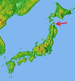
, stretching out towards Hokkaidō
Hokkaido
, formerly known as Ezo, Yezo, Yeso, or Yesso, is Japan's second largest island; it is also the largest and northernmost of Japan's 47 prefectural-level subdivisions. The Tsugaru Strait separates Hokkaido from Honshu, although the two islands are connected by the underwater railway Seikan Tunnel...
. Administratively the area is a part of Aomori Prefecture
Aomori Prefecture
is a prefecture of Japan located in the Tōhoku Region. The capital is the city of Aomori.- History :Until the Meiji Restoration, the area of Aomori prefecture was known as Mutsu Province....
.
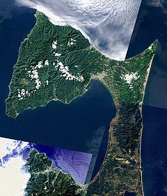
Shaped like an axe pointing west, the peninsula has a thin "axe handle" connecting the mountainous "axe blade" to the mainland
Mainland
Mainland is a name given to a large landmass in a region , or to the largest of a group of islands in an archipelago. Sometimes its residents are called "Mainlanders"...
. The coasts maintain a thin scattering of population but the interior is practically uninhabited.
Shimokita is best known as the site of Mount Osore
Mount Osore
is a region in the center of remote Shimokita Peninsula of Aomori Prefecture, Japan.According to popular mythology, Mount Osore marks the entrance to Hell, with a small brook running to the neighboring Lake Usorisan that is equated to the Sanzu River, a river that deceased souls needed to cross of...
, the mythical Japanese location of the entrance to Hell
Hell
In many religious traditions, a hell is a place of suffering and punishment in the afterlife. Religions with a linear divine history often depict hells as endless. Religions with a cyclic history often depict a hell as an intermediary period between incarnations...
. The lush Yagen Valley
Yagen Valley
Yagen Onsen is a hot spring located in Ohata-machi, Mutsu city, Aomori Prefecture.This onsen and Oku-yagen Onsen are described in this article.-Access:...
, known for its hot springs, is also located in Shimokita, as is Hotokegaura
Hotokegaura
The Hotokegaura are a series of rock formations naturally carved from the cliffs in village of Sai on the west coast of the Shimokita Peninsula in Aomori, Japan....
, wind-carved cliffs said to resemble Buddhas, and the village of Rokkasho
Rokkasho, Aomori
is a village located in the Kamikita District of northeastern Aomori Prefecture in the Tōhoku region of Japan. As of 2009, the village had an estimated population of 10,890 and a density of 43 persons per km². Its total area was 253.01 km².-Geography:...
, home to a range of nuclear facilities.

External links
41.546488°N 140.913048°W (Ōmazaki:Northernmost point)41.431015°N 141.461892°W (Shiriyazaki:the northeast point)

