
Shinnecock Canal
Encyclopedia
The Shinnecock Canal is a canal that cuts across the South Fork of Long Island
at Hampton Bays, New York
. At 4700 feet (1,432.6 m) long, it connects Great Peconic Bay and the north fork of Long Island with Shinnecock Bay and the Atlantic Ocean
. The canal opened to traffic in 1892.
Although "the Hamptons" officially begins about 10 miles (16.1 km) west at Westhampton, New York
, the Shinnecock Canal in popular imagination marks the beginning of the Hamptons
since traffic is funneled across two highway bridges (Sunrise Highway and Montauk Highway
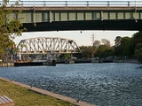
) or the Long Island Rail Road
bridge.
Talk of building a canal on Shinnecock Creek had gone on for years and a popular myth says the Shinnecock Indian Nation
and Montaukett
Native Americans built the original canal in the 17th century. The canal’s location is specifically called Canoe Place because of this.
A Canal lock system had to be built in 1919 to alleviate dramatic differences in height between the two bays. The Peconic Bay to the north can be three feet higher than Shinnecock Bay. Further, the two bays have opposite tide cycles.
The lock system now is the only navigation lock operating on Long Island.
The lock increased the salinity levels in Shinnecock Bay which had nearly assumed fresh water proportions and was resulting in a dying off of its shell fish population even though it was separated from the Atlantic by a narrow barrier island
.
 Shinnecock Bay’s salinity levels were solidified during Great Hurricane of 1938 which broke through the barrier island to form Shinnecock Inlet
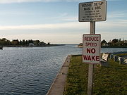
almost due south of the canal. The new inlet has created a short cut to the Atlantic that is now used by 27,000 boats per year.
The canal itself varies in width from 100 to 180 ft (30.5 to 54.9 m). The lock is 41 feet (12.5 m) wide and 250 feet (76.2 m) long. The lowest bridge is the fixed railroad bridge, with a height of 22 feet (6.7 m) vertical clearance above the water. The highway bridges have 23 feet (7 m) and 25 feet (7.6 m) vertical clearance.
The name Canoe Place comes from the Indian word "Niamuck" which described a canoe portage
from the north bay "Peconic" to the south bay "Shinnecock" & vice versa. That they carried their canoes seems to indicate that there was no water connection between these two bodies of water. There is no evidence that the Montauketts or Shinnecocks dug a canal, together or separately. The 1918 construction on the canal was of "Tide Gates" & bulkeading, not "Locks" as are in place today. This did not alleviate the difference in the hydrographic elevation but sought to mitigate it. Another effect of this as found in the records of the New York State Salt Water Bays Commission was the water level of Shinnecock Bay was raised by one foot.
South Fork, Suffolk County, New York
The South Fork of Suffolk County, New York, United States is a peninsula in the southeast part of the county on the South Shore of Long Island. The South Fork includes most of the Hamptons. The shorter, more northerly peninsula is known as the North Fork....
at Hampton Bays, New York
Hampton Bays, New York
Hampton Bays is a hamlet in Suffolk County, New York, United States. The population was 12,236 at the 2000 census.Hampton Bays is in the Town of Southampton.-Geography:...
. At 4700 feet (1,432.6 m) long, it connects Great Peconic Bay and the north fork of Long Island with Shinnecock Bay and the Atlantic Ocean
Atlantic Ocean
The Atlantic Ocean is the second-largest of the world's oceanic divisions. With a total area of about , it covers approximately 20% of the Earth's surface and about 26% of its water surface area...
. The canal opened to traffic in 1892.
Although "the Hamptons" officially begins about 10 miles (16.1 km) west at Westhampton, New York
Westhampton, New York
Westhampton is a hamlet in Suffolk County, New York, United States. The population was 2,869 at the 2000 census.Westhampton is in the Town of Southampton.-Geography:Westhampton is located at ....
, the Shinnecock Canal in popular imagination marks the beginning of the Hamptons
Hamptons
The Hamptons may refer to several villages and hamlets in the towns of Southampton and East Hampton on the far east end of Suffolk County in Long Island, New York. These townships occupy the South Fork of Long Island, stretching into the Atlantic Ocean. The Hamptons form a popular seaside resort,...
since traffic is funneled across two highway bridges (Sunrise Highway and Montauk Highway
Montauk Highway
Montauk Highway is one of the original through highways of Long Island, New York, extending from Jamaica, in the New York City borough of Queens to Montauk Point in Suffolk County, a distance of approximately 100 miles ....
) or the Long Island Rail Road
Long Island Rail Road
The Long Island Rail Road or LIRR is a commuter rail system serving the length of Long Island, New York. It is the busiest commuter railroad in North America, serving about 81.5 million passengers each year. Established in 1834 and having operated continuously since then, it is the oldest US...
bridge.
Talk of building a canal on Shinnecock Creek had gone on for years and a popular myth says the Shinnecock Indian Nation
Shinnecock Indian Nation
The Shinnecock Indian Nation is a federally recognized tribe, headquartered in Suffolk County, New York, on the south shore of Long Island. Shinnecock are an Algonquian people from Long Island...
and Montaukett
Montaukett
The Montaukett is an Algonquian-speaking Native American group native to the eastern end of Long Island, New York and one of the thirteen historical indigenous centers...
Native Americans built the original canal in the 17th century. The canal’s location is specifically called Canoe Place because of this.
A Canal lock system had to be built in 1919 to alleviate dramatic differences in height between the two bays. The Peconic Bay to the north can be three feet higher than Shinnecock Bay. Further, the two bays have opposite tide cycles.
The lock system now is the only navigation lock operating on Long Island.
The lock increased the salinity levels in Shinnecock Bay which had nearly assumed fresh water proportions and was resulting in a dying off of its shell fish population even though it was separated from the Atlantic by a narrow barrier island
Barrier island
Barrier islands, a coastal landform and a type of barrier system, are relatively narrow strips of sand that parallel the mainland coast. They usually occur in chains, consisting of anything from a few islands to more than a dozen...
.
Shinnecock Inlet
Shinnecock Inlet is the easternmost of five major inlets connecting bays to the Atlantic Ocean through the narrow 100-mile-long Outer barrier that stretches from New York City to Southhampton, New York on the south shore of Long Island. It splits Westhampton Island from the peninsula extending from...
almost due south of the canal. The new inlet has created a short cut to the Atlantic that is now used by 27,000 boats per year.
The canal itself varies in width from 100 to 180 ft (30.5 to 54.9 m). The lock is 41 feet (12.5 m) wide and 250 feet (76.2 m) long. The lowest bridge is the fixed railroad bridge, with a height of 22 feet (6.7 m) vertical clearance above the water. The highway bridges have 23 feet (7 m) and 25 feet (7.6 m) vertical clearance.
The name Canoe Place comes from the Indian word "Niamuck" which described a canoe portage
Portage
Portage or portaging refers to the practice of carrying watercraft or cargo over land to avoid river obstacles, or between two bodies of water. A place where this carrying occurs is also called a portage; a person doing the carrying is called a porter.The English word portage is derived from the...
from the north bay "Peconic" to the south bay "Shinnecock" & vice versa. That they carried their canoes seems to indicate that there was no water connection between these two bodies of water. There is no evidence that the Montauketts or Shinnecocks dug a canal, together or separately. The 1918 construction on the canal was of "Tide Gates" & bulkeading, not "Locks" as are in place today. This did not alleviate the difference in the hydrographic elevation but sought to mitigate it. Another effect of this as found in the records of the New York State Salt Water Bays Commission was the water level of Shinnecock Bay was raised by one foot.