Shire of Capel
Encyclopedia
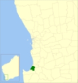
The Shire of Capel is a Local Government Area
in the South West region of Western Australia
, taking in the land between the cities of Bunbury
and Busselton
about 200 kilometres (124 mi) south of the state capital, Perth
. The Shire covers an area of 557.6 square kilometres (215.3 sq mi), and its seat of government is the town of Capel
. The Shire of Capel has 29km of beach frontage onto Geographe Bay including Forrest, Peppermint Grove, Minninup and Dalyellup beaches.
Local Government Areas of Western Australia
The Australian state of Western Australia is divided into 141 local government areas...
in the South West region of Western Australia
Western Australia
Western Australia is a state of Australia, occupying the entire western third of the Australian continent. It is bounded by the Indian Ocean to the north and west, the Great Australian Bight and Indian Ocean to the south, the Northern Territory to the north-east and South Australia to the south-east...
, taking in the land between the cities of Bunbury
Bunbury, Western Australia
The port city of Bunbury is the third largest city in Western Australia after the State Capital Perth and Mandurah. It is situated south of Perth's central business district...
and Busselton
Busselton, Western Australia
-Growth and development:According to the Australian Bureau of Statistics the Shire had a permanent resident population of 25,950 in 2004 with the town of Busselton accounting for 67% or 17,400 of the total. The Shire's permanent population is expected to continue to increase significantly to...
about 200 kilometres (124 mi) south of the state capital, Perth
Perth, Western Australia
Perth is the capital and largest city of the Australian state of Western Australia and the fourth most populous city in Australia. The Perth metropolitan area has an estimated population of almost 1,700,000....
. The Shire covers an area of 557.6 square kilometres (215.3 sq mi), and its seat of government is the town of Capel
Capel, Western Australia
Capel is a town in the South West region of Western Australia, located 212 kilometres south of Perth and midway between Bunbury and Busselton....
. The Shire of Capel has 29km of beach frontage onto Geographe Bay including Forrest, Peppermint Grove, Minninup and Dalyellup beaches.
History
Capel was initially constituted as the Bunbury Road Board in 1894 (as distinguished from the Bunbury Municipal District). In 1907, it was renamed to Capel, and on 1 July 1961, it became a Shire Council following changes to the Local Government Act.Towns and localities
- CapelCapel, Western AustraliaCapel is a town in the South West region of Western Australia, located 212 kilometres south of Perth and midway between Bunbury and Busselton....
- BoyanupBoyanup, Western AustraliaBoyanup is a town located on the South Western Highway in the South West agricultural region, 195 km south of Perth and 18 km south-east of Bunbury, Western Australia....
- DalyellupDalyellup, Western AustraliaDalyellup is an outer southern suburb of Bunbury, a city in Western Australia, located within the Shire of Capel local government area. The suburb was established in 1999 when the Department of Housing and Works entered into a joint venture with Satterley Property Group to develop Dalyellup Beach...
- Elgin
- Forrest Beach
- Gelorup
- Gwindinup
- Peppermint Grove BeachPeppermint Grove Beach, Western AustraliaPeppermint Grove Beach is a residential subdivision and beachside town in the South West region of Western Australia. Its local government area is the Shire of Capel and it is located northwest of Capel on the Geographe Bay coast near the Capel River mouth....
- Stirling Estate
- Stratham

