
Shire of Greenough
Encyclopedia
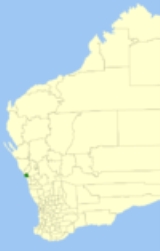
The Shire of Greenough was a Local Government Area
in the Mid West region of Western Australia
, 420 kilometres (261 mi) north of the state capital, Perth
surrounding the city of Geraldton. The Shire covered an area of 1752 square kilometres (676.5 sq mi), and its seat of government was the outer Geraldton suburb of Utakarra
.
Historically a rural area, with the growth of Geraldton in recent years as a port and city, the areas of the Shire closest to Geraldton became increasingly urbanised. The council amalgamated with the City of Geraldton
in 2007 to form the City of Geraldton-Greenough
. As of 1 July 2011, it is now part of the City of Greater Geraldton
.
, which split away in 1875 and Mullewa
, which formed in 1911. In 1951, Geraldton and Greenough merged, and in 1961 became the Shire of Geraldton-Greenough following the enactment of the Local Government Act 1960. In 1965, it was renamed the Shire of Greenough.
.
The Greenough electors successfully petitioned for a referendum to determine whether amalgamation should proceed. This was held on 2 December 2006, and with a participation rate of 28.74%, a majority of 80% voted against the proposal. However, under the Local Government Act 1995
(clause 10 of Schedule 2.1) as the vote did not attract 50% of registered voters, it did not meet the requirements for a valid poll.
The councillors of both local government authorities resigned at the end of April 2007, and the first elections for new councillors took place in October 2007.
Local Government Areas of Western Australia
The Australian state of Western Australia is divided into 141 local government areas...
in the Mid West region of Western Australia
Western Australia
Western Australia is a state of Australia, occupying the entire western third of the Australian continent. It is bounded by the Indian Ocean to the north and west, the Great Australian Bight and Indian Ocean to the south, the Northern Territory to the north-east and South Australia to the south-east...
, 420 kilometres (261 mi) north of the state capital, Perth
Perth, Western Australia
Perth is the capital and largest city of the Australian state of Western Australia and the fourth most populous city in Australia. The Perth metropolitan area has an estimated population of almost 1,700,000....
surrounding the city of Geraldton. The Shire covered an area of 1752 square kilometres (676.5 sq mi), and its seat of government was the outer Geraldton suburb of Utakarra
Utakarra, Western Australia
Utakarra is an eastern suburb of Geraldton, Western Australia. Its Local Government Area is the City of Greater Geraldton. Prior to 1 July 2007, it was the seat of government of the Shire of Greenough.The suburb was gazetted in 1972....
.
Historically a rural area, with the growth of Geraldton in recent years as a port and city, the areas of the Shire closest to Geraldton became increasingly urbanised. The council amalgamated with the City of Geraldton
City of Geraldton
The City of Geraldton was a Local Government Area in the Mid West region of Western Australia, north of the state capital, Perth on the Indian Ocean...
in 2007 to form the City of Geraldton-Greenough
City of Geraldton-Greenough
The City of Geraldton-Greenough was a Local Government Area in the Mid West region of Western Australia, north of the state capital, Perth on the Indian Ocean...
. As of 1 July 2011, it is now part of the City of Greater Geraldton
City of Greater Geraldton
The City of Greater Geraldton is a Local Government Area in the Mid West region of Western Australia, north of the state capital, Perth on the Indian Ocean...
.
History
The Greenough and Geraldton Road Boards - the latter not to be confused with the Geraldton Municipality - were gazetted in 1871. Initially, Greenough included all of MurchisonShire of Murchison
The Shire of Murchison is a large agricultural region in the central part of Western Australia, and is the only shire in Australia without a town. At the 2006 Census, it was also the least populous Local Government Area in Western Australia.-Description:...
, which split away in 1875 and Mullewa
Shire of Mullewa
The Shire of Mullewa was a Local Government Area in the Mid West region of Western Australia, about east of the city of Geraldton and about north of the state capital, Perth. The Shire covered an area of , and its seat of government was the town of Mullewa...
, which formed in 1911. In 1951, Geraldton and Greenough merged, and in 1961 became the Shire of Geraldton-Greenough following the enactment of the Local Government Act 1960. In 1965, it was renamed the Shire of Greenough.
Amalgamation
A recommendation was made to the Minister for Local Government by the Local Government Advisory Board in August 2006 to amalgamate the Shire of Greenough with the City of GeraldtonCity of Geraldton
The City of Geraldton was a Local Government Area in the Mid West region of Western Australia, north of the state capital, Perth on the Indian Ocean...
.
The Greenough electors successfully petitioned for a referendum to determine whether amalgamation should proceed. This was held on 2 December 2006, and with a participation rate of 28.74%, a majority of 80% voted against the proposal. However, under the Local Government Act 1995
Local Government Act 1995
The Local Government Act 1995 is an act of the Western Australian Parliament which lays down the responsibilities, powers and procedures for election of Local Government Bodies.-External links:*...
(clause 10 of Schedule 2.1) as the vote did not attract 50% of registered voters, it did not meet the requirements for a valid poll.
The councillors of both local government authorities resigned at the end of April 2007, and the first elections for new councillors took place in October 2007.
Wards
The shire was divided into four wards until 2005 - West and Tarcoola Wards, each with 4 councillors, and North and South wards, each with 2 councillors. In May 2005, due to a redistribution of boundaries, the Central and Wandina Wards, each with 4 councillors, and the Chapman North Ward with 3 councillors were created.Towns and localities
Localities/Suburbs:
|
|
Towns:
|
Population
| Year | Population |
|---|---|
| 1921 | 1,375 |
| 1933 | 1,556 |
| 1947 | 1,567 |
| 1954 | 1,371 |
| 1961 | 1,321 |
| 1966 | 1,594 |
| 1971 | 1,920 |
| 1976 | 2,979 |
| 1981 | 4,612 |
| 1986 | 5,798 |
| 1991 | 7,626 |
| 1996 | 10,337 |
| 2001 | 11,927 |
| 2006 | 13,545 |