
Shire of Metcalfe
Encyclopedia
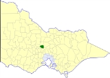
The Shire of Metcalfe was a Local Government Area located about 105 kilometres (65 mi) north-northwest of Melbourne
, the state capital of Victoria
, Australia
, and 45 kilometres (28 mi) south of the regional city of Bendigo
. The shire covered an area of 590.52 square kilometres (228 sq mi), and existed from 1860 until 1995.
Metcalfe absorbed two boroughs which had previously been separately governed. On 7 October 1870, the Taradale borough was united, while the Chewton borough, created on 14 December 1860 with an area of 23.31 square kilometres (9 sq mi), was united on 2 May 1916.
On 20 January 1995, the Shire was abolished, and merged with the City of Castlemaine
and the Shires of Maldon
and Newstead
into the Shire of Mount Alexander. Redesdale
and the area around Lake Eppalock
was merged into the City of Greater Bendigo
.
* Estimate in the 1958 Victorian Year Book.
Melbourne
Melbourne is the capital and most populous city in the state of Victoria, and the second most populous city in Australia. The Melbourne City Centre is the hub of the greater metropolitan area and the Census statistical division—of which "Melbourne" is the common name. As of June 2009, the greater...
, the state capital of Victoria
Victoria (Australia)
Victoria is the second most populous state in Australia. Geographically the smallest mainland state, Victoria is bordered by New South Wales, South Australia, and Tasmania on Boundary Islet to the north, west and south respectively....
, Australia
Australia
Australia , officially the Commonwealth of Australia, is a country in the Southern Hemisphere comprising the mainland of the Australian continent, the island of Tasmania, and numerous smaller islands in the Indian and Pacific Oceans. It is the world's sixth-largest country by total area...
, and 45 kilometres (28 mi) south of the regional city of Bendigo
Bendigo, Victoria
Bendigo is a major regional city in the state of Victoria, Australia, located very close to the geographical centre of the state and approximately north west of the state capital Melbourne. It is the second largest inland city and fourth most populous city in the state. The estimated urban...
. The shire covered an area of 590.52 square kilometres (228 sq mi), and existed from 1860 until 1995.
History
Metcalfe was first incorporated as a district on 14 August 1860, and became a shire on 18 July 1865.Metcalfe absorbed two boroughs which had previously been separately governed. On 7 October 1870, the Taradale borough was united, while the Chewton borough, created on 14 December 1860 with an area of 23.31 square kilometres (9 sq mi), was united on 2 May 1916.
On 20 January 1995, the Shire was abolished, and merged with the City of Castlemaine
City of Castlemaine
The City of Castlemaine was a Local Government Area located about north-northwest of Melbourne, the state capital of Victoria, Australia, and south of the regional city of Bendigo. The City covered an area of , and existed from 1855 until 1995.-History:...
and the Shires of Maldon
Shire of Maldon
The Shire of Maldon was a Local Government Area located about northwest of Melbourne, the state capital of Victoria, Australia, and southwest of the regional city of Bendigo. The shire covered an area of , and existed from 1858 until 1995.-History:...
and Newstead
Shire of Newstead
The Shire of Newstead was a Local Government Area located about northwest of Melbourne, the state capital of Victoria, Australia. The shire covered an area of , and existed from 1860 until 1995.-History:...
into the Shire of Mount Alexander. Redesdale
Redesdale, Victoria
Redesdale is a town in central Victoria, Australia., north west of the state capital, Melbourne. It is located partly in the City of Greater Bendigo Local Government Area and partly in the Shire of Mount Alexander...
and the area around Lake Eppalock
Lake Eppalock
Lake Eppalock is a man-made lake located in North Central Victoria, Australia. It's situated on the Campaspe River between the city of Bendigo and the town of Heathcote and serves as a major water storage facility for both places...
was merged into the City of Greater Bendigo
City of Greater Bendigo
The City of Greater Bendigo is a Local Government Area in Victoria, Australia. It is located in the central-western part of the state. It has an area of 3,048 square kilometres...
.
Wards
Metcalfe was divided into four ridings , each of which elected three councillors:- Chewton Riding
- Harcourt Riding
- Taradale Riding
- East Riding
Towns and localities
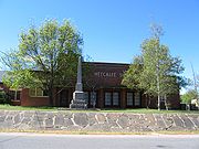
- MetcalfeMetcalfe, VictoriaMetcalfe is a small community in central Victoria, Australia. At the 2006 census, Metcalfe had a population of 531.Metcalfe Post Office opened on 13 December 1866....
- BarfoldBarfold, VictoriaBarfold is a locality situated on the Heathcote-Kyneton Road in Victoria, Australia. It has a community hall, Barfold Hall, and an Anglican church, Barfold Union Church....
- Barkers Creek
- ChewtonChewton, VictoriaChewton is a town in central Victoria, Australia. The town is located in the Shire of Mount Alexander Local Government Area, 116 kilometres north west of the state capital, Melbourne. At the 2006 census, Chewton had a population of 403.-History:...
- ElphinstoneElphinstone, VictoriaElphinstone is a town in Victoria, Australia. The town sits at the junction of the former Calder Highway and the former Pyrenees Highway between Malmsbury and Castlemaine near Taradale and Chewton...
- FaradayFaraday, VictoriaFaraday is a locality situated on the Calder Highway, north west of Melbourne in Victoria, Australia.-History:The Post Office opened on 1 April 1867, but was closed in 1880, postal services being provided from nearby Harcourt....
- Golden PointGolden Point, VictoriaGolden Point is a suburb of Ballarat, Victoria, Australia located south east of the CBD. It is one of the few original suburbs of Ballarat that was established during the Victorian gold rush days. At the 2006 census, Golden Point had a population of 2,147...
- HarcourtHarcourt, VictoriaHarcourt is a small Central Highlands town located approximately 9 km northeast of Castlemaine, where the Midland Highway meets the Calder Highway. At the 2006 census, Harcourt had a population of 439.-History:...
- Harcourt North
- Langley
- Myrtle Creek
- RedesdaleRedesdale, VictoriaRedesdale is a town in central Victoria, Australia., north west of the state capital, Melbourne. It is located partly in the City of Greater Bendigo Local Government Area and partly in the Shire of Mount Alexander...
- Sutton GrangeSutton Grange, VictoriaSutton Grange is a small country town located approximately 30 km south of Bendigo in Victoria, Australia.It has a very small population of approximately 150 people, most of which consist of old sheep farming families...
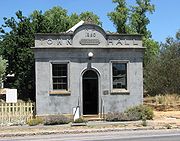
- TaradaleTaradale, VictoriaTaradale is a small town in Victoria, Australia. It is located on the Calder Highway between Melbourne and Bendigo. Its local government area is the Shire of Mount Alexander. At the 2006 census, Taradale had a population of 199....
Population
| Year | Population |
|---|---|
| 1954 | 2,425 |
| 1958 | 2,560* |
| 1961 | 2,316 |
| 1966 | 2,163 |
| 1971 | 1,983 |
| 1976 | 2,041 |
| 1981 | 2,173 |
| 1986 | 2,665 |
| 1991 | 3,125 |
* Estimate in the 1958 Victorian Year Book.