Shire of Wickepin
Encyclopedia
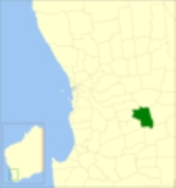
The Shire of Wickepin is a Local Government Area
in the Wheatbelt region of Western Australia
, east of Narrogin
and about 220 kilometres (137 mi) southeast of the state capital, Perth
. The Shire covers an area of 2042 square kilometres (788 sq mi), and its seat of government is the town of Wickepin
.
Prior to 20 October 2007, the shire was divided into 5 wards:
Local Government Areas of Western Australia
The Australian state of Western Australia is divided into 141 local government areas...
in the Wheatbelt region of Western Australia
Western Australia
Western Australia is a state of Australia, occupying the entire western third of the Australian continent. It is bounded by the Indian Ocean to the north and west, the Great Australian Bight and Indian Ocean to the south, the Northern Territory to the north-east and South Australia to the south-east...
, east of Narrogin
Narrogin, Western Australia
Narrogin is a large town in the Wheatbelt region of Western Australia, southeast of Perth on the Great Southern Highway between Pingelly and Wagin...
and about 220 kilometres (137 mi) southeast of the state capital, Perth
Perth, Western Australia
Perth is the capital and largest city of the Australian state of Western Australia and the fourth most populous city in Australia. The Perth metropolitan area has an estimated population of almost 1,700,000....
. The Shire covers an area of 2042 square kilometres (788 sq mi), and its seat of government is the town of Wickepin
Wickepin, Western Australia
Wickepin is a town in the Wheatbelt region of Western Australia, south-east of Perth and east of Narrogin. At the 2006 census, Wickepin had a population of 244.-History:...
.
History
In 1909, the Wickepin Road District was created. The Road Board consisted of a chairman, secretary and seven members. On 1 July 1961, it became a Shire under the Local Government Act 1960.Wards
The shire is at present undivided with its nine councillors representing the entire shire.Prior to 20 October 2007, the shire was divided into 5 wards:
- Townsite Ward (2 councillors)
- North Ward (2 councillors)
- Central Ward (2 councillors)
- South Ward (2 councillors)
- East Ward (1 councillor)
Towns and localities
- WickepinWickepin, Western AustraliaWickepin is a town in the Wheatbelt region of Western Australia, south-east of Perth and east of Narrogin. At the 2006 census, Wickepin had a population of 244.-History:...
- Gillimanning
- HarrismithHarrismith, Western AustraliaHarrismith is a small town in the Wheatbelt region of Western Australia, approximately south-east of Perth between the towns of Wickepin and Kulin.-History:...
- Malyalling
- TincurrinTincurrin, Western AustraliaTincurrin is a small town in the Wheatbelt region of Western Australia, south-east of Perth and within the Shire of Wickepin.-History:Tincurrin's name is of Aboriginal origin, and was first recorded in 1892 by J.O. Oxley, a surveyor, for a spring in the area, but the meaning is not known...
- Toolibin
- Wogolin
- YealeringYealering, Western AustraliaYealering is a town in the Wheatbelt region of Western Australia, approximately 220km south-east of Perth between the towns of Wickepin and Corrigin. It is located beside a lake of the same name. While the town's population is small, it services a large agricultural district in the northern...
Population
| Year | Population |
|---|---|
| 1911 | 1,146 |
| 1921 | 1,454 |
| 1933 | 1,598 |
| 1947 | 1,153 |
| 1954 | 1,334 |
| 1961 | 1,276 |
| 1966 | 1,380 |
| 1971 | 1,144 |
| 1976 | 1,076 |
| 1981 | 1,018 |
| 1986 | 951 |
| 1991 | 915 |
| 1996 | 833 |
| 2001 | 713 |
| 2006 | 716 |

