Sierra Negra
Encyclopedia
Sierra Negra is an extinct volcanic companion peak of Mexico's highest mountain, the Pico de Orizaba
(Citlaltepetl). At up to 4,640 m (15,220 ft) above sea level (depending on which source one consults) it is one of Mexico's highest peaks, perhaps even the fourth highest, though it is usually listed fifth. However, because it is overshadowed by its much higher companion it is not as well known as, for instance, the slightly lower Matlalcueitl
(Malinche), and is often not included in lists of Mexico's mountains.
The summit of Sierra Negra is the site for one of the world's premier astronomical instruments, the Large Millimeter Telescope
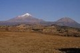
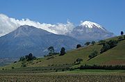
. The service road for this project is claimed to be the highest road in North America. A part of the telescope facility is visible as a white dot in the first picture below and more clearly in the second picture.
The name Sierra Negra is confusing, because a 'Sierra' is usually a mountain range rather than a single peak, and there is a Sierra often called the Sierra Negra which lies to the south of this peak, along the border of the states of Puebla
and Veracruz
. However, it is the name that occurs on the official INEGI
maps and is the one that is most commonly used by English speakers to refer to the mountain. The Nahuatl
names "Tliltepetl" or "Atlitzin" are attached to it by some, though they have also been used for other mountains in the area. Speakers of Orizaba Nahuatl
call the mountain Istaktepetl Ikni 'the White Mountain's Sibling' (the Pico de Orizaba being the White Mountain).


Pico de Orizaba
The Pico de Orizaba, or Citlaltépetl , is a stratovolcano, the highest mountain in Mexico and the third highest in North America. It rises above sea level in the eastern end of the Trans-Mexican Volcanic Belt, on the border between the states of Veracruz and Puebla...
(Citlaltepetl). At up to 4,640 m (15,220 ft) above sea level (depending on which source one consults) it is one of Mexico's highest peaks, perhaps even the fourth highest, though it is usually listed fifth. However, because it is overshadowed by its much higher companion it is not as well known as, for instance, the slightly lower Matlalcueitl
Matlalcueitl (volcano)
La Malinche mountain, also known as Matlalcuéyetl, Matlalcueitl or Malintzin, is an inactive volcano located in Tlaxcala and Puebla states, in Mexico. Officially, its summit reaches above sea level, though in some articles it is considered to be 4,503 m...
(Malinche), and is often not included in lists of Mexico's mountains.
The summit of Sierra Negra is the site for one of the world's premier astronomical instruments, the Large Millimeter Telescope
Large Millimeter Telescope
The Large Millimeter Telescope was inaugurated in Mexico on 22 November 2006. It is the world's largest and most sensitive single-aperture telescope in its frequency range, built for observing radio waves in the wave lengths from approximately 0.85 to 4 mm...
. The service road for this project is claimed to be the highest road in North America. A part of the telescope facility is visible as a white dot in the first picture below and more clearly in the second picture.
The name Sierra Negra is confusing, because a 'Sierra' is usually a mountain range rather than a single peak, and there is a Sierra often called the Sierra Negra which lies to the south of this peak, along the border of the states of Puebla
Puebla
Puebla officially Estado Libre y Soberano de Puebla is one of the 31 states which, with the Federal District, comprise the 32 Federal Entities of Mexico. It is divided in 217 municipalities and its capital city is Puebla....
and Veracruz
Veracruz
Veracruz, formally Veracruz de Ignacio de la Llave officially Estado Libre y Soberano de Veracruz de Ignacio de la Llave , is one of the 31 states that, along with the Federal District, comprise the 32 federative entities of Mexico. It is divided in 212 municipalities and its capital city is...
. However, it is the name that occurs on the official INEGI
National Institute of Statistics, Geography, and Data Processing
The National Institute of Statistic and Geography is an autonomous agency of the Mexican Government dedicated to coordinate the National System of Statistical and Geographical Information of the country...
maps and is the one that is most commonly used by English speakers to refer to the mountain. The Nahuatl
Nahuatl
Nahuatl is thought to mean "a good, clear sound" This language name has several spellings, among them náhuatl , Naoatl, Nauatl, Nahuatl, Nawatl. In a back formation from the name of the language, the ethnic group of Nahuatl speakers are called Nahua...
names "Tliltepetl" or "Atlitzin" are attached to it by some, though they have also been used for other mountains in the area. Speakers of Orizaba Nahuatl
Orizaba Nahuatl
Orizaba Nahuatl is a native American language spoken in the southeastern Mexican state of Veracruz mostly in the area to the south of the city of Orizaba. It is also known as Orizaba Aztec and Náhuatl de la Sierra de Zongolica. It has 79 percent intelligibility with Morelos Nahuatl. There is a...
call the mountain Istaktepetl Ikni 'the White Mountain's Sibling' (the Pico de Orizaba being the White Mountain).


See also
- 4000 meter peaks of México
- 4000 meter peaks of North America
- Mountain peaks of MéxicoMountain peaks of MexicoThis article comprises three sortable tables of the major mountain peaks of Mexico.Topographic elevation is the vertical distance above the reference geoid, a precise mathematical model of the Earth's sea level as an equipotential gravitational surface. Topographic prominence is the elevation...
- Mountain peaks of North AmericaMountain peaks of North AmericaThis article comprises three sortable tables of major mountain peaks of greater North America.This article defines greater North America as the portion of the continental landmass of the Americas extending northward from Panama plus the islands surrounding that landmass...
External links
- The Large Millimeter Telescope (The altitude figure of 4640 m is from this site)
- Peakbagger.com: Sierra Nerga

