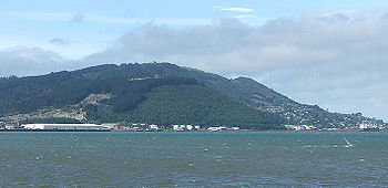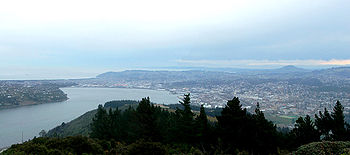
Signal Hill, New Zealand
Encyclopedia


Dunedin
Dunedin is the second-largest city in the South Island of New Zealand, and the principal city of the Otago Region. It is considered to be one of the four main urban centres of New Zealand for historic, cultural, and geographic reasons. Dunedin was the largest city by territorial land area until...
, New Zealand
New Zealand
New Zealand is an island country in the south-western Pacific Ocean comprising two main landmasses and numerous smaller islands. The country is situated some east of Australia across the Tasman Sea, and roughly south of the Pacific island nations of New Caledonia, Fiji, and Tonga...
. It is located close to, and due north of, the head of the Otago Harbour
Otago Harbour
Otago Harbour is the natural harbour of Dunedin, New Zealand, consisting of a long, much-indented stretch of generally navigable water separating the Otago Peninsula from the mainland. They join at its southwest end, from the harbour mouth...
and reaches an elevation of 393 m (1289 ft). The suburbs Ravensbourne
Ravensbourne, New Zealand
Ravensbourne is a suburb of the New Zealand city of Dunedin. It is located on the steep southeastern slopes of Signal Hill above the Otago Harbour. It lies on the harbour's northern shore, east-northeast of the city centre...
, St. Leonards, and Opoho
Opoho
Opoho is a suburb of the New Zealand city of Dunedin. It sits on the western flank of Signal Hill, New Zealand, to the northeast of the city centre, overlooking North East Valley and the Dunedin Botanic Gardens....
lie on its southern, eastern, and northwestern flanks, respectively. To the northwest is North East Valley
North East Valley
North East Valley is a suburb of the New Zealand city of Dunedin.-Geography and demographics:...
, the thalweg
Thalweg
Thalweg in geography and fluvial geomorphology signifies the deepest continuous inline within a valley or watercourse system.-Hydrology:In hydrological and fluvial landforms, the thalweg is a line drawn to join the lowest points along the entire length of a stream bed or valley in its downward...
of Lindsay Creek, a tributary of the Water of Leith
Water of Leith, New Zealand
The Water of Leith , is a small river in the South Island of New Zealand.It rises to the north of the city of Dunedin, flowing for 14 kilometres southeast through the northern part of the city and the campus of the University of Otago before reaching the Otago Harbour...
. The southernmost spur of Signal Hill, Logan Point, has been extensively quarried for road gravel. State Highway 88
New Zealand State Highway 88
State Highway 88 is a New Zealand State Highway connecting the city centre of Dunedin with Port Chalmers, which is the location of Dunedin's main port facilities and home of one of New Zealand's major container terminals. It is roughly 18 km long....
skirts the foot of the hill close to the edge of the Otago Harbour.
A secondary summit of the hill (height 329 m) is capped by a monument to the New Zealand Centennial of 1940, a large structure including two large bronze figures representing "History" and "The Thread of Life" designed by F. W. Sturrock and F. W. Staub. Although commissioned for the centenary of the signing of the Treaty of Waitangi
Treaty of Waitangi
The Treaty of Waitangi is a treaty first signed on 6 February 1840 by representatives of the British Crown and various Māori chiefs from the North Island of New Zealand....
, the monument was not constructed until the 1950s, owing to the enforced strictures of World War II
World War II
World War II, or the Second World War , was a global conflict lasting from 1939 to 1945, involving most of the world's nations—including all of the great powers—eventually forming two opposing military alliances: the Allies and the Axis...
. A large stone from Edinburgh
Edinburgh
Edinburgh is the capital city of Scotland, the second largest city in Scotland, and the eighth most populous in the United Kingdom. The City of Edinburgh Council governs one of Scotland's 32 local government council areas. The council area includes urban Edinburgh and a rural area...
in Scotland
Scotland
Scotland is a country that is part of the United Kingdom. Occupying the northern third of the island of Great Britain, it shares a border with England to the south and is bounded by the North Sea to the east, the Atlantic Ocean to the north and west, and the North Channel and Irish Sea to the...
is also incorporated in the monument, symbolising the ties between Dunedin and its sister city.
The monument is surrounded by a scenic reserve 180 hectares in extent. This park was inaugurated as a much smaller park in 1926, and has gradually been extended to its current size. The reserve, located only five kilometres from central Dunedin, is a popular site for both locals and visitors, and affords an excellent panoramic view over the city.
In October 2006, a series of bush fires caused extensive damage to the plantations of forest which cover the western slopes of the hill.

