Simpson Park Mountains
Encyclopedia

Lander County, Nevada
Lander County is a county located in the U.S. state of Nevada. As of the 2000 census, the population was 5,794. Its county seat is Battle Mountain.-History:...
and Eureka
Eureka County, Nevada
Eureka County is a county located in the U.S. state of Nevada. As of the 2000 census, the population was 1,651. Its county seat is Eureka.Eureka County is part of the Elko Micropolitan Statistical Area.-History:...
Counties, in central Nevada
Nevada
Nevada is a state in the western, mountain west, and southwestern regions of the United States. With an area of and a population of about 2.7 million, it is the 7th-largest and 35th-most populous state. Over two-thirds of Nevada's people live in the Las Vegas metropolitan area, which contains its...
in the western United States
United States
The United States of America is a federal constitutional republic comprising fifty states and a federal district...
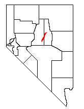
. The steep range runs in a southwest-northeasterly direction between the Toiyabe Range
Toiyabe Range
The Toiyabe Range is a range of mountains in central Nevada in the western United States. It starts in northwestern Nye County north of Tonopah, Nevada and runs approximately 120 miles north-northeast through eastern Lander County, making it the second longest range in the state...
and the Roberts Mountains
Roberts Mountains
The Roberts Mountains are located in central Nevada in the western United States. The mountains are found in Eureka County, east of the Simpson Park Mountains and west and southwest of the Sulpher Spring Range. The range reaches a peak at Roberts Creek Mountain, at 10,133 feet .The Bureau of Land...
. The mountains reach an elevation of 9,147 feet at Fagin Mountain, and cover an area of 310 square miles (800 km²).

Bureau of Land Management
The Bureau of Land Management is an agency within the United States Department of the Interior which administers America's public lands, totaling approximately , or one-eighth of the landmass of the country. The BLM also manages of subsurface mineral estate underlying federal, state and private...
manages 98% of the Simpson Park Mountains, and 2% is privately held. Principal vegetation types are: Piñon
Piñon
Piñon may refer to:* Pinyon pine * Pinon Airplant, Tillandsia excelsa-Places:* Piñon, Arizona, United States* Piñon, New Mexico, United States* Pinon, Aisne, a commune of the Aisne department in France...
-juniper
Juniper
Junipers are coniferous plants in the genus Juniperus of the cypress family Cupressaceae. Depending on taxonomic viewpoint, there are between 50-67 species of juniper, widely distributed throughout the northern hemisphere, from the Arctic, south to tropical Africa in the Old World, and to the...
—43.5%, Sagebrush
Sagebrush
Sagebrush is a common name of a number of shrubby plant species in the genus Artemisia native to western North America;Or, the sagebrush steppe ecoregion, having one or more kinds of sagebrush, bunchgrasses and others;...
scrub—25.4%, and Sagebrush steppe
Steppe
In physical geography, steppe is an ecoregion, in the montane grasslands and shrublands and temperate grasslands, savannas, and shrublands biomes, characterized by grassland plains without trees apart from those near rivers and lakes...
—18.5%. Trees found in the range include: western juniper (Juniperus occidentalis), Utah Juniper (Juniperus osteosperma), and Single-leaf Pinyon
Single-leaf Pinyon
The Single-leaf Pinyon, ', is a pine in the pinyon pine group, native to the United States and northwest Mexico. The range is in southernmost Idaho, western Utah, Arizona, southwest New Mexico, Nevada, eastern and southern California and northern Baja California.It occurs at moderate altitudes from...
(Pinus monophylla). Coyotes and pika
Pika
The pika is a small mammal, with short limbs, rounded ears, and short tail. The name pika is used for any member of the Ochotonidae, a family within the order of lagomorphs, which also includes the Leporidae . One genus, Ochotona, is recognised within the family, and it includes 30 species...
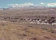
s roam the Simpson Park Mountains.
The range is named after James H. Simpson
James H. Simpson
James Hervey Simpson was an officer in the U.S. Army and a member of the United States Topographical Engineers.-Early years:He was born in New Brunswick, New Jersey on March 9, 1813, the son of John Simpson and Mary Brunson. He graduated from the United States Military Academy in 1832 and was...
, who surveyed a transportation route just south of the range in 1858.

