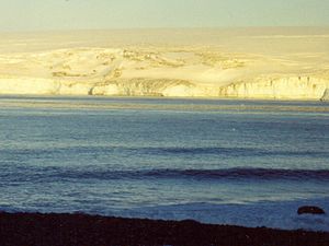
Smolyan Point
Encyclopedia

South Bay, Livingston Island
South Bay is a wide bay indenting for the south coast of Livingston Island in the South Shetland Islands, Antarctica. The bay is lying northwest of False Bay and east of Walker Bay, and is entered between Hannah Point and Miers Bluff....
, Livingston Island in the South Shetland Islands
South Shetland Islands
The South Shetland Islands are a group of Antarctic islands, lying about north of the Antarctic Peninsula, with a total area of . By the Antarctic Treaty of 1959, the Islands' sovereignty is neither recognized nor disputed by the signatories and they are free for use by any signatory for...
, Antarctica forming the northwest side of the entrance to Emona Anchorage
Emona Anchorage
Emona Anchorage is a roughly square embayment, the internal part of South Bay, Livingston Island in the South Shetland Islands, Antarctica used as an anchorage for ships visiting the Bulgarian base St...
. The ice-covered point shows conspicuous radial crevasses spreading inland and ends up with a 25 m wide and 4 m high rock. The feature was formed as a result of Pimpirev Glacier
Pimpirev Glacier
Pimpirev Glacier on Livingston Island drains southeastwards towards Pimpirev Beach. It is situated west of Perunika Glacier, south of Tundzha Glacier and the glacial divide between the Drake Passage and Bransfield Strait, and east of Kamchiya Glacier...
's retreat in the late 20th century.
Smolyan
Smolyan
Smolyan is a town and ski resort in the very south of Bulgaria not far from the border with Greece. It is the administrative and industrial centre of the homonymous Smolyan Province...
is the name of a town in the Rhodope Mountains
Rhodope Mountains
The Rhodopes are a mountain range in Southeastern Europe, with over 83% of its area in southern Bulgaria and the remainder in Greece. Its highest peak, Golyam Perelik , is the seventh highest Bulgarian mountain...
in southern Bulgaria
Bulgaria
Bulgaria , officially the Republic of Bulgaria , is a parliamentary democracy within a unitary constitutional republic in Southeast Europe. The country borders Romania to the north, Serbia and Macedonia to the west, Greece and Turkey to the south, as well as the Black Sea to the east...
.
Location
The point is located at 62°37′27.7"S 60°25′57"W which is 1.86 km east-northeast of Ereby PointEreby Point
Ereby Point is a point lying 4.5 mi east-northeast of Hannah Point along the north side of South Bay, Livingston Island in the South Shetland Islands, Antarctica. The name Erebys Bay was applied to South Bay on a 1825 chart by James Weddell, Ereby Point was applied by the UK-APC in 1961 in...
and 3.7 km northwest of Hespérides Point
Hespérides Point
Hespérides Point is a rocky point of land projecting into South Bay north-northwest of Johnsons Dock, Livingston Island in the South Shetland Islands, Antarctica and forming the southwest side of the entrance to Emona Anchorage. Surmounted by Hesperides Hill...
. (Bulgarian mapping in 1996, 2005 and 2009 from a 1995/96 Bulgarian topographic survey).
Maps
- L.L. Ivanov. Livingston Island: Central-Eastern Region. Scale 1:25000 topographic map. Sofia: Antarctic Place-names Commission of Bulgaria, 1996.
- L.L. Ivanov et al. Antarctica: Livingston Island and Greenwich Island, South Shetland Islands. Scale 1:100000 topographic map. Sofia: Antarctic Place-names Commission of Bulgaria, 2005.
- L.L. Ivanov. Antarctica: Livingston Island and Greenwich, Robert, Snow and Smith Islands. Scale 1:120000 topographic map. Troyan: Manfred Wörner Foundation, 2009. ISBN 978-954-92032-6-4

