

Somerville Community Path
Encyclopedia
Somerville, Massachusetts
Somerville is a city in Middlesex County, Massachusetts, United States, located just north of Boston. As of the 2010 census, the city had a total population of 75,754 and was the most densely populated municipality in New England. It is also the 17th most densely populated incorporated place in...
, from the Cambridge border near Davis Square
Davis Square
Davis Square is a major intersection in the northwestern section of Somerville, Massachusetts where several streets meet: Holland Street, Dover Street, Day Street, Elm Street, Highland Avenue, and College Avenue.- Location :...
to the Cambridge border near Lechmere Square
Lechmere Square
Lechmere Square is located at the intersection of Cambridge Street and First Street in East Cambridge, Massachusetts. It was originally named for the Colonial-era landowner Richard Lechmere, a Loyalist who returned to England at the beginning of the American Revolution. His lands were later seized...
. Roughly 0.8 mile
Mile
A mile is a unit of length, most commonly 5,280 feet . The mile of 5,280 feet is sometimes called the statute mile or land mile to distinguish it from the nautical mile...
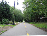
s (1.3 km) of the path is finished and in use. The two finished segments feature pavement interspersed with brick, and surrounded by grass, trees, pedestrian connections to nearby streets, and a community garden. The path is lit at night and snowplowed in the winter.
If completed, the project would connect the Minuteman Bikeway, Fitchburg Cutoff Path
Fitchburg Cutoff Path
The Fitchburg Cutoff Path is a short, unpaved multi-use rail trail located in suburban Boston, Massachusetts.The 0.8 mile path runs from Brighton Street in Belmont, Massachusetts to the Alewife station at the northern end of the MBTA Red Line in Cambridge...
, and Cambridge Linear Park
Cambridge Linear Park
The Linear Park is a mixed-use path, about one mile long, running through Cambridge and Somerville , and connecting the Minuteman Bikeway and the Fitchburg Cutoff Path near Alewife with the Somerville Community Path at Davis Square. The path is used for bicycling, walking, jogging, and inline...
to the Charles River Bike Path
Charles River Bike Path
The Charles River Bike Path is a mixed-use path in the Boston, Massachusetts area. It follows both shores of the Charles River from Boston, Massachusetts to Norumbega Park in Newton, passing through Watertown and Waltham...
and downtown Boston, Massachusetts. This would create connections for Bedford, Lexington, Concord, Arlington, Belmont, Somerville, and Cambridge to the proposed East Coast Greenway
East Coast Greenway
The East Coast Greenway, or ECG, is a project to create a nearly urban path linking the major cities of the Atlantic coast of the United States, from Calais, Maine, to Key West, Florida, for non-motorized human transportation...
.
Route
The "Alewife Linear Park" segment of the Somerville Community Path is a continuation of the Cambridge Linear Park, which runs from the Cambridge-Somerville border west to Alewife StationAlewife (MBTA station)
Alewife, located at the intersection of Alewife Brook Parkway and Cambridgepark West in Cambridge, Massachusetts, is a local intermodal transportation hub. It is the northern terminus of the MBTA's Red Line, and a bus terminal for several local routes and one intercity route. It opened in 1985.The...
, the Fitchburg Cutoff Path
Fitchburg Cutoff Path
The Fitchburg Cutoff Path is a short, unpaved multi-use rail trail located in suburban Boston, Massachusetts.The 0.8 mile path runs from Brighton Street in Belmont, Massachusetts to the Alewife station at the northern end of the MBTA Red Line in Cambridge...
, and the Minuteman Bikeway. Proceeding eastbound, the bicycle and pedestrian paths diverge slightly just before Seven Hills Park, to pass through Davis Square. Pedestrians have grade-level crosswalks, and bicyclists are routed via nearby streets or may walk their bikes. They join again at Grove Street and continue to Cedar Street (though there is an MBTA busway linking Grove Street to College Avenue).
Community activists hope to finish a 2.5-mile (4.0-kilometre) extension of the Somerville Community Path by connecting this segment to the existing path in Lechmere Square
Lechmere Square
Lechmere Square is located at the intersection of Cambridge Street and First Street in East Cambridge, Massachusetts. It was originally named for the Colonial-era landowner Richard Lechmere, a Loyalist who returned to England at the beginning of the American Revolution. His lands were later seized...
in eastern Cambridge (at the North Point development
North Point development
NorthPoint is a mixed-use redevelopment of an old railroad yard in the East Cambridge section of Cambridge, Massachusetts.Situated on a rail yard originally built by the Boston and Maine Railroad, Pan Am Systems decided to turn the now-unused rail yard into a large development, containing...
).
The next segment to the east, from Cedar Street to Central Street, is in the design phase, funded by a tourism grant from the Massachusetts Turnpike Authority. This segment currently consists of disused railroad tracks under a forest canopy. A feasibility study was performed in 2006 on the segment from School Street in Somerville to the Cambridge border.
The final segment, from Lowell Street to Lechmere/North Point, is proposed to be built in conjunction with the Somerville-Medford extension of the Green Line light rail
Green Line (MBTA)
The Green Line is a streetcar system run by the Massachusetts Bay Transportation Authority in the Boston, Massachusetts area of the United States. It is the oldest line of Boston's subway, which is known locally as the 'T'. The Green Line runs underground downtown and on the surface in outlying...
. This will mainly run alongside the active Lowell Line
Lowell Line
The Lowell Line is a railroad line of the MBTA Commuter Rail system, running north from Boston to Lowell, Massachusetts. Originally built as the Boston and Lowell Railroad, and later operated as part of the Boston and Maine Railroad's Southern Division, the line was one of the first railroads in...
commuter rail tracks, except for a disused railroad right-of-way near Lechmere. The path would parallel that route, while connecting with the new stations to be built along the way. Cooperation between the projects is mandated by the state environmental review process; preliminary drawings have been published. As of December 2008, the Green Line extension must be completed by the end of 2014 under an agreement to meet federal clean air requirements. The Massachusetts Executive Office of Transportation
Massachusetts Executive Office of Transportation
The Massachusetts Department of Transportation oversees roads, public transit, aeronautics, and transportation licensing and registration in the Commonwealth of Massachusetts...
has agreed to design the path extension as part of the Green Line project, but it will not be responsible for building the path.
The Urban Ring project may result in a connecting "rail with trail" path along the Grand Junction Railroad
Grand Junction Railroad
The Grand Junction Railroad is an 8.55-mile long railroad in the Boston, Massachusetts area, connecting the railroads heading west and north from Boston...
right-of-way.
History
The Boston and Lowell RailroadBoston and Lowell Railroad
The Boston and Lowell Railroad is a historic railroad that operated in Massachusetts. It was one of the first railroads in North America and the first major one in the state...
was chartered in 1830 and started service in 1835. The main line is now the MBTA Lowell Line
Lowell Line
The Lowell Line is a railroad line of the MBTA Commuter Rail system, running north from Boston to Lowell, Massachusetts. Originally built as the Boston and Lowell Railroad, and later operated as part of the Boston and Maine Railroad's Southern Division, the line was one of the first railroads in...
.
From near Alewife on the Cambridge-Arlington border, to Lowell Street in Somerville, the Cambridge Linear Park and Somerville Community Path follow a railroad right-of-way
Right-of-way (railroad)
A right-of-way is a strip of land that is granted, through an easement or other mechanism, for transportation purposes, such as for a trail, driveway, rail line or highway. A right-of-way is reserved for the purposes of maintenance or expansion of existing services with the right-of-way...
that was laid out in 1870, and later known as the "Fitchburg Freight Cutoff", "Somerville Freight Cut-off", "Somerville Freight Spur", or Davis Square Freight Cut-Off. (In the 1980s and 1990s, after the Red Line extension, there remained an active freight spur from the Lowell Line to the "MaxPak" site, where the last industrial user went out of business in 2002.) The Boston and Lowell built the connection from its main line (at Somerville Junction
Somerville Junction
Somerville Junction was the name of a railroad junction and station in Somerville, Massachusetts, United States. The station was located at the site of the present-day park near the intersection of Centre and Woodbine Streets. Nearby, a westward connector split off from the main line of the...
, at modern-day Lowell Street) to the Lexington and Arlington Railroad (now mostly converted to the Minuteman Bikeway), which the Boston and Lowell had just acquired. Passenger service ran via this connection from 1870 until 1927. An extension connected to the Fitchburg Railroad
Fitchburg Railroad
The Fitchburg Railroad is a former railroad company, which built a railroad line across northern Massachusetts, USA, leading to and through the Hoosac Tunnel. The Fitchburg was leased to the Boston and Maine Railroad in 1900...
main line, now the MBTA Fitchburg Line
Fitchburg Line
The Fitchburg Line is an MBTA line that runs from Boston's North Station to Fitchburg, Massachusetts. The line is along the tracks of the former Fitchburg Railroad, which was a railroad line across northern Massachusetts, United States, leading to and through the Hoosac Tunnel. It is one of the...
, between what are now Alewife Station and Brighton Street, Belmont.
After various corporate acquisitions and the decline of railroad service in the United States, the public Massachusetts Bay Transportation Authority
Massachusetts Bay Transportation Authority
The Massachusetts Bay Transportation Authority, often referred to as the MBTA or simply The T, is the public operator of most bus, subway, commuter rail and ferry systems in the greater Boston, Massachusetts, area. Officially a "body politic and corporate, and a political subdivision" of the...
acquired the rights of way in 1973.
The existing paths from Alewife to Davis Square were created in 1985 by the MBTA, Cambridge, and Somerville, in conjunction with the extension of the MBTA Red Line from Harvard to Alewife. The Davis-to-Alewife segment of the Red Line was built using a cut-and-cover method. The surface landscaping for the path was added after subway tunnel construction was complete. Between Davis and Porter, the subway diverges from the surface street pattern, using a deep bore tunnel.
The path from Davis to Cedar Street was completed later.
Funding for the Cedar to Central portion was requested by the City of Somerville under the American Recovery and Reinvestment Act of 2009
American Recovery and Reinvestment Act of 2009
The American Recovery and Reinvestment Act of 2009, abbreviated ARRA and commonly referred to as the Stimulus or The Recovery Act, is an economic stimulus package enacted by the 111th United States Congress in February 2009 and signed into law on February 17, 2009, by President Barack Obama.To...
, but at the time was also included in the 2010 Boston MPO Transportation Improvement Plan for conventional matching state and federal funds.
External links
- Friends of the Community Paths
- Official page from the City of Somerville