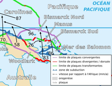
South Bismarck Plate
Encyclopedia

Bismarck Sea
The Bismarck Sea lies in the southwestern Pacific Ocean to the north of the island of Papua New Guinea and to the south of the Bismarck Archipelago and Admiralty Islands. Like the Bismarck archipelago, it is named in honour of the German chancellor Otto von Bismarck...
. The eastern part of New Guinea
New Guinea
New Guinea is the world's second largest island, after Greenland, covering a land area of 786,000 km2. Located in the southwest Pacific Ocean, it lies geographically to the east of the Malay Archipelago, with which it is sometimes included as part of a greater Indo-Australian Archipelago...
and the island of New Britain
New Britain
New Britain, or Niu Briten, is the largest island in the Bismarck Archipelago of Papua New Guinea. It is separated from the island of New Guinea by the Dampier and Vitiaz Straits and from New Ireland by St. George's Channel...
are on this plate.
Tectonics
Convergent boundaryConvergent boundary
In plate tectonics, a convergent boundary, also known as a destructive plate boundary , is an actively deforming region where two tectonic plates or fragments of lithosphere move toward one another and collide...
s line the southern border including the subduction zone responsible for the formation of New Britain
New Britain
New Britain, or Niu Briten, is the largest island in the Bismarck Archipelago of Papua New Guinea. It is separated from the island of New Guinea by the Dampier and Vitiaz Straits and from New Ireland by St. George's Channel...
and the Solomon Islands
Solomon Islands
Solomon Islands is a sovereign state in Oceania, east of Papua New Guinea, consisting of nearly one thousand islands. It covers a land mass of . The capital, Honiara, is located on the island of Guadalcanal...
. Many earthquakes occur in this area particularly around New Britain. GPS data shows the South Bismarck plate, though north of the Australian plate boundary, is being pushed by Australia in a northerly direction while the North Bismarck Plate
North Bismarck Plate
The North Bismarck Plate is a small tectonic plate located in the Bismarck Sea off the northeast coast of New Guinea.-Tectonics:To the north it collides with the Pacific Plate and the Caroline Plate, part of the western part subducts under the Woodlark Plate of New Guinea, and it is separated from...
is being dragged by the Pacific plate easterly. The line delineating the two is called the Bismarck Seismic Sea Lineation (BSSL), and it is not known where this line ends on the West side towards New Ireland
New Ireland (island)
New Ireland is a large island in Papua New Guinea, approximately 7,404 km² in area. It is the largest island of the New Ireland Province, lying northeast of the island of New Britain. Both islands are part of the Bismarck Archipelago, named after Otto von Bismarck, and they are separated by...
.

