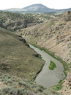
South Fork Humboldt River
Encyclopedia
The South Fork of the Humboldt River has its origins in a fan-shaped group of canyons draining the western slopes of the Ruby Mountains
in northeastern Nevada
. These headwaters run from Ruby Dome
south to King Peak
, and include Echo, Box, Kleckner, North Furlong, Long, Segunda, Drown, and Rattlesnake Canyons. Streams draining these canyons exit the mountains and converge at an elevation of 5775 feet (1,760.2 m), near the town of Lee
and within the tribal lands of the Te-Moak tribe of the South Fork Band of the Western Shoshone
.
Continuing its northwest course, the river merges with the flow of Huntington Creek, passes through the historic area of Twin Bridges, and then enters the more recent South Fork Reservoir, State Park
, and Dam. It then passes though South Fork Canyon, where it merges with the flows of Ten-mile and Dixie Creeks. It was here that on September 25, 1846 the Donner Party
wagon train completed the segment of their journey on the Hastings Cutoff
, and rejoined the original California Trail
.
After an estimated total of 38 miles (61.2 km), the South Fork flows into the main branch of the Humboldt River
at approximately 40°46.3′N 115°53.3′W and at an elevation of 5070 feet (1,545.3 m), about 7 miles (11.3 km) southwest of the city of Elko
.

Ruby Mountains
The Ruby Mountains comprise one of the many mountain ranges of the Great Basin in the western United States. They are the predominant range in Elko County, in the northeastern section of the state of Nevada. To the north is Secret Pass and the East Humboldt Range, and from there the Rubies run...
in northeastern Nevada
Nevada
Nevada is a state in the western, mountain west, and southwestern regions of the United States. With an area of and a population of about 2.7 million, it is the 7th-largest and 35th-most populous state. Over two-thirds of Nevada's people live in the Las Vegas metropolitan area, which contains its...
. These headwaters run from Ruby Dome
Ruby Dome
Ruby Dome, the highest peak of the Ruby Mountains and Elko County, is located in northeastern Nevada in the western United States. It rises from a base elevation of about to a height of . It is located about southeast of the city of Elko....
south to King Peak
King Peak (Nevada)
King Peak is the southernmost summit above in the Ruby Mountains of Elko County, in northeastern Nevada in the western United States. To the west is Rattlesnake Canyon, and to the east is Overland Creek Canyon, which drains into the Ruby Valley). The Ruby Crest National Recreation Trail passes...
, and include Echo, Box, Kleckner, North Furlong, Long, Segunda, Drown, and Rattlesnake Canyons. Streams draining these canyons exit the mountains and converge at an elevation of 5775 feet (1,760.2 m), near the town of Lee
Lee, Nevada
Lee is an unincorporated community ghost town in Elko County, Nevada, United States. The population of Lee is about 50.The community is part of the Elko Micropolitan Statistical Area. Lee is located at the western foothills of the extensive Ruby Mountains range....
and within the tribal lands of the Te-Moak tribe of the South Fork Band of the Western Shoshone
Shoshone
The Shoshone or Shoshoni are a Native American tribe in the United States with three large divisions: the Northern, the Western and the Eastern....
.
Continuing its northwest course, the river merges with the flow of Huntington Creek, passes through the historic area of Twin Bridges, and then enters the more recent South Fork Reservoir, State Park
South Fork State Recreation Area
South Fork State Recreation Area is a state park unit of Nevada, USA, surrounding the South Fork Reservoir. Located south of the town of Elko, it is in the Central Nevada Region of Nevada State Parks....
, and Dam. It then passes though South Fork Canyon, where it merges with the flows of Ten-mile and Dixie Creeks. It was here that on September 25, 1846 the Donner Party
Donner Party
The Donner Party was a group of American pioneers who set out for California in a wagon train. Delayed by a series of mishaps, they spent the winter of 1846–47 snowbound in the Sierra Nevada...
wagon train completed the segment of their journey on the Hastings Cutoff
Hastings Cutoff
The Hastings Cutoff was an alternate route for emigrants to travel to California, as proposed by Lansford Hastings.In 1845, Hastings published a guide entitled The Emigrant's Guide to Oregon and California...
, and rejoined the original California Trail
California Trail
The California Trail was an emigrant trail of about across the western half of the North American continent from Missouri River towns to what is now the state of California...
.
After an estimated total of 38 miles (61.2 km), the South Fork flows into the main branch of the Humboldt River
Humboldt River
The Humboldt River runs through northern Nevada in the western United States. At approximately long it is the second longest river in the Great Basin, after the Bear River. It has no outlet to the ocean, but instead empties into the Humboldt Sink...
at approximately 40°46.3′N 115°53.3′W and at an elevation of 5070 feet (1,545.3 m), about 7 miles (11.3 km) southwest of the city of Elko
Elko, Nevada
Elko is a city in Elko County, Nevada, United States. The population was 18,297 at the 2010 census. It is the county seat of Elko County. The city straddles the Humboldt River....
.


