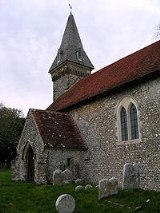
South Stoke, West Sussex
Encyclopedia
South Stoke is a small village and civil parish
in the Arun
District of West Sussex
, England
. It is located two miles (3 km) to the north of Arundel
, and is situated on the west bank of the River Arun
on the edge of Arundel Park. It is reached by road from Arundel. A footpath leads to North Stoke
on the east bank. The civil parish, which includes the hamlet of Offham, covers an area of 534.86 hectares (1,321.7 acre) and has a population of 44 persons (2001 census). The parish church, Saxon
in origin, is dedicated to St Leonard
. There is one public house, the Black Rabbit at Offham.
The Monarch's Way
long-distance footpath crosses the western edge of the parish between Houghton
and Arundel
.
The village population declined after 1806 when common land was enclosed to make Arundel Park, depriving the villagers of sheep grazing land.
, when the village was named as "Stoches". Built of flint
it has a thin western tower which carries a 19th century broach spire with four slatted dormer windows. There is one bell dated 1657. The porch is 13th century.
Civil parish
In England, a civil parish is a territorial designation and, where they are found, the lowest tier of local government below districts and counties...
in the Arun
Arun
Arun is a local government district in West Sussex, England. It contains the towns of Arundel, Bognor Regis and Littlehampton, and takes its name from the River Arun, which runs through the centre of the district.-History:...
District of West Sussex
West Sussex
West Sussex is a county in the south of England, bordering onto East Sussex , Hampshire and Surrey. The county of Sussex has been divided into East and West since the 12th century, and obtained separate county councils in 1888, but it remained a single ceremonial county until 1974 and the coming...
, England
England
England is a country that is part of the United Kingdom. It shares land borders with Scotland to the north and Wales to the west; the Irish Sea is to the north west, the Celtic Sea to the south west, with the North Sea to the east and the English Channel to the south separating it from continental...
. It is located two miles (3 km) to the north of Arundel
Arundel
Arundel is a market town and civil parish in the South Downs of West Sussex in the south of England. It lies south southwest of London, west of Brighton, and east of the county town of Chichester. Other nearby towns include Worthing east southeast, Littlehampton to the south and Bognor Regis to...
, and is situated on the west bank of the River Arun
River Arun
The Arun is a river in the English county of West Sussex. Its source is a series of small streams in the St Leonard's Forest area, to the east of Horsham...
on the edge of Arundel Park. It is reached by road from Arundel. A footpath leads to North Stoke
North Stoke, West Sussex
North Stoke is a village in the Horsham District of West Sussex, England. It is just over north of Arundel and south of Amberley railway station, and is at the end of a no through road from the station....
on the east bank. The civil parish, which includes the hamlet of Offham, covers an area of 534.86 hectares (1,321.7 acre) and has a population of 44 persons (2001 census). The parish church, Saxon
Anglo-Saxons
Anglo-Saxon is a term used by historians to designate the Germanic tribes who invaded and settled the south and east of Great Britain beginning in the early 5th century AD, and the period from their creation of the English nation to the Norman conquest. The Anglo-Saxon Era denotes the period of...
in origin, is dedicated to St Leonard
Leonard of Noblac
Leonard of Noblac or of Limoges or de Noblet , is a Frankish saint closely associated with the town and abbey of Saint-Léonard-de-Noblat, in Haute-Vienne, in the Limousin of France.-Traditional biography:According to the romance that...
. There is one public house, the Black Rabbit at Offham.
The Monarch's Way
Monarch's Way
The Monarch's Way is a long-distance footpath in England that approximates the escape route taken by King Charles II in 1651 after being defeated in the Battle of Worcester.Most of the footpath is waymarked...
long-distance footpath crosses the western edge of the parish between Houghton
Houghton, West Sussex
Houghton is a village and civil parish in the Arun District of West Sussex, England. It is located on the River Arun five kilometres to the north of Arundel...
and Arundel
Arundel
Arundel is a market town and civil parish in the South Downs of West Sussex in the south of England. It lies south southwest of London, west of Brighton, and east of the county town of Chichester. Other nearby towns include Worthing east southeast, Littlehampton to the south and Bognor Regis to...
.
The village population declined after 1806 when common land was enclosed to make Arundel Park, depriving the villagers of sheep grazing land.
The parish church
The 11th century building is recorded in the Domesday BookDomesday Book
Domesday Book , now held at The National Archives, Kew, Richmond upon Thames in South West London, is the record of the great survey of much of England and parts of Wales completed in 1086...
, when the village was named as "Stoches". Built of flint
Flint
Flint is a hard, sedimentary cryptocrystalline form of the mineral quartz, categorized as a variety of chert. It occurs chiefly as nodules and masses in sedimentary rocks, such as chalks and limestones. Inside the nodule, flint is usually dark grey, black, green, white, or brown in colour, and...
it has a thin western tower which carries a 19th century broach spire with four slatted dormer windows. There is one bell dated 1657. The porch is 13th century.

