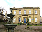
Spencer Place
Encyclopedia
Harehills
Harehills is an inner-city area of east Leeds, West Yorkshire, England. It is approximately north east of Leeds city centre. Harehills is situated between the A58 and the A64 .- Overview :...
and Chapeltown
Chapeltown, West Yorkshire
Chapeltown is a suburb of north-east Leeds, in West Yorkshire, England, and is the centre of the city's British African-Caribbean community. It is approximately one mile north of Leeds city centre...
in the city of Leeds
Leeds
Leeds is a city and metropolitan borough in West Yorkshire, England. In 2001 Leeds' main urban subdivision had a population of 443,247, while the entire city has a population of 798,800 , making it the 30th-most populous city in the European Union.Leeds is the cultural, financial and commercial...
, West Yorkshire
West Yorkshire
West Yorkshire is a metropolitan county within the Yorkshire and the Humber region of England with a population of 2.2 million. West Yorkshire came into existence as a metropolitan county in 1974 after the passage of the Local Government Act 1972....
, England
England
England is a country that is part of the United Kingdom. It shares land borders with Scotland to the north and Wales to the west; the Irish Sea is to the north west, the Celtic Sea to the south west, with the North Sea to the east and the English Channel to the south separating it from continental...
.
At the north end it intersects with Harehills Lane, at the corner of Potternewton
Potternewton
Potternewton is a suburb and parish of north-east Leeds, West Yorkshire, England, situated between Chapeltown and Chapel Allerton, mainly in the LS7 postcode. It is between Scott Hall Road on the West and Roundhay Road on the East, with Harehills Lane on the North...
Park. At the south end it forms a junction with Roundhay
Roundhay
Roundhay is a large suburb and City Council ward of north-east Leeds, West Yorkshire, England, largely within the LS8 postcode. The ward boundary is the A6120 ring road on the north and the A58 Wetherby Road on the south and east. The boundary follows Gledhow Valley Road to the west before heading...
Road. It is home to the Leeds Jamia Mosque and Chapeltown Health Centre.
It was the heart of one of Leeds
Leeds
Leeds is a city and metropolitan borough in West Yorkshire, England. In 2001 Leeds' main urban subdivision had a population of 443,247, while the entire city has a population of 798,800 , making it the 30th-most populous city in the European Union.Leeds is the cultural, financial and commercial...
' main red light districts and was associated with prostitution
Prostitution
Prostitution is the act or practice of providing sexual services to another person in return for payment. The person who receives payment for sexual services is called a prostitute and the person who receives such services is known by a multitude of terms, including a "john". Prostitution is one of...
, gun crime and drug crime. Spencer Place is used as part of the Chapeltown Carnival.