
St Albans, New South Wales
Encyclopedia
St Albans is a small and historic village
on the Macdonald River
, New South Wales
, Australia
, about 94 kilometres (65 mi) north west of Sydney
. At the 2006 census
, St Albans had a population of 72 people.
in Hertfordshire
, England
, north of London
.
In the early part of the colonial settlement of New South Wales, the Macdonald Valley was an important agricultural area because of its accessibility by water. However with the development of railways and extensive agricultural development west of the Great Dividing Range
, the Macdonald Valley became less important and declined to become a remote backwater. The valley is often referred to by the locals as the "Forgotten Valley".
St Albans is on the banks of the Macdonald River, a tributary of the Hawkesbury River
which is about 15 kilometres (9.5 mi) to the south. The village was opened for settlement in 1842 largely because it had become an important stopping point for farmers and others in the area wanting to ship their goods down the Hawkesbury River to Sydney. St Albans was at the navigational upper limit of the Macdonald River. This upper portion of the river has since been drastically reduced to navigation with sand and silt.
provide access to St Albans from the Sydney region along roads following the old goat and horse tracks on either side of the Macdonald. Both roads meander (partly unsealed) through rich country and farms of cattle, melons, orchards and corn. On either side of the river are historic homes and spectacular sandstone towering hills. One route to St Albans is to turn left just before entering Wisemans Ferry
township, cross the Hawkesbury via the Webbs Creek
Ferry, then follow up the western side of the Macdonald to the village. The alternative route is through Wisemans Ferry township and north across the Hawkesbury via another ferry, then follow the eastern side of the Macdonald. The first bridge to cross the river links the two roads at St Albans.
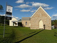 The St Albans Anglican Church (Saint Alban The Martyr), near the top of Wharf Road is the only church still in use. A timber chapel, opened in 1843, was replaced by the current stone building thirty years later. See http://www.hawkesbury.net.au/activities/c17.html for photo.
Another interesting stone church remaining in the village is the old Wesleyan Methodist church in Espie Street. This was built in 1902 and is now in private hands, a reminder of almost 150 years of Wesleyan
influence in the Macdonald valley.
The funerals of those close to town usually progressed by boat to the old St Albans Burial Ground, a few kilometres south of the village beside the river, founded in 1826. This site had in the past suffered much by neglect, floods and vandalism but is now preserved.
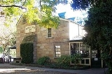
The Court House is perched on wooded slopes of Hawkesbury sandstone, high above the beautiful Macdonald River and St Albans. The building, originally consisting of a courtroom, police station and lock-up, now offers comfortable overnight and holiday accommodation. The original prisoners' exercise yard is now a recreational area. The two original cells have been retained as unique bathrooms. The building is recognised by the National Trust and has a City of Hawkesbury heritage classification. See http://www.courthousestalbans.com.au/facilities.html for photos of courthouse and cells.
The inn occupies a very picturesque position facing the river and is in an excellent state of preservation. In July 1842 the first land sales were held in St Albans. John Sullivan of Wollombi purchased seven allotments on which he built the Settlers Arms Inn. It was constructed at a cattle drover's camp on the limit of navigation on the Macdonald River. It still trades as “a purveyor of conversation, beer, and accommodation”. There is some confusion as to the construction date. 1836 was the year the license was issued, number. 36/10, but a report by the Hawkesbury correspondent in the Sydney Morning Herald on 1 March 1848 reads: "The township which a few years ago was marked out upon this river, has been built on by only one individual, Mr. Sullivan. He has erected a very reasonable stone house two stories high, which we understand he intends to open as an Inn." [Implying that it was not open then.]. See http://www.saintalbans.org.au/ for picture of the Inn.
The newly restored 1837 cottage took 8 years to build and 2 years to restore. It has vertical timber slab, wattle and daub construction with its calico ceilings under a shingle roof. Price Morris, an emancipist/farmer took up the 50 acre (20 hectare) property grant in 1837. In the 1830’s the area was settled by Welsh Methodists and the Price Morris cottage became the centre for Methodist meetings and worship. A Methodist church was built in St. Albans but the cottage continued as an occasional meeting place until the late 1960s. One of preachers was the grandfather of the late Sir Alan Walker
, founder of the Central Methodist Mission
. See http://www.pricemorris.com.au/history.htm http://www.pricemorris.com.au/ for photos
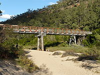 There were devastating floods in 1867, 1889, 1913, and particularly 1949. The town lies fifty feet above the riverbed and the floor of the bridge is forty feet from the sand. In the 1889 flood the bridge was covered, the Court House was not washed away but the Police quarters were. The water rose to the eaves of Jurds Hotel (Settlers Arms Inn) and left a hole seven feet deep in front of it. The old house was of stone, but some of it washed away. The floodwaters rose to the veranda eaves and washed away five houses, and another newly built on the other side of the river.
Village
A village is a clustered human settlement or community, larger than a hamlet with the population ranging from a few hundred to a few thousand , Though often located in rural areas, the term urban village is also applied to certain urban neighbourhoods, such as the West Village in Manhattan, New...
on the Macdonald River
Macdonald River (St Albans)
There are two rivers named Macdonald River in New South Wales, Australia. See Macdonald RiverThe Macdonald River is a tributary of the Hawkesbury River. It rises near Putty and flows about 60 kilometers generally south-east to where it joins the Hawkesbury River near Wisemans Ferry.The upper...
, New South Wales
New South Wales
New South Wales is a state of :Australia, located in the east of the country. It is bordered by Queensland, Victoria and South Australia to the north, south and west respectively. To the east, the state is bordered by the Tasman Sea, which forms part of the Pacific Ocean. New South Wales...
, Australia
Australia
Australia , officially the Commonwealth of Australia, is a country in the Southern Hemisphere comprising the mainland of the Australian continent, the island of Tasmania, and numerous smaller islands in the Indian and Pacific Oceans. It is the world's sixth-largest country by total area...
, about 94 kilometres (65 mi) north west of Sydney
Sydney
Sydney is the most populous city in Australia and the state capital of New South Wales. Sydney is located on Australia's south-east coast of the Tasman Sea. As of June 2010, the greater metropolitan area had an approximate population of 4.6 million people...
. At the 2006 census
Census in Australia
The Australian census is administered once every five years by the Australian Bureau of Statistics. The most recent census was conducted on 9 August 2011; the next will be conducted in 2016. Prior to the introduction of regular censuses in 1961, they had also been run in 1901, 1911, 1921, 1933,...
, St Albans had a population of 72 people.
History
The "Village of Macdonald" was surveyed in 1837 but renamed St Albans on 26 January 1841 after the City of St AlbansSt Albans
St Albans is a city in southern Hertfordshire, England, around north of central London, which forms the main urban area of the City and District of St Albans. It is a historic market town, and is now a sought-after dormitory town within the London commuter belt...
in Hertfordshire
Hertfordshire
Hertfordshire is a ceremonial and non-metropolitan county in the East region of England. The county town is Hertford.The county is one of the Home Counties and lies inland, bordered by Greater London , Buckinghamshire , Bedfordshire , Cambridgeshire and...
, England
England
England is a country that is part of the United Kingdom. It shares land borders with Scotland to the north and Wales to the west; the Irish Sea is to the north west, the Celtic Sea to the south west, with the North Sea to the east and the English Channel to the south separating it from continental...
, north of London
London
London is the capital city of :England and the :United Kingdom, the largest metropolitan area in the United Kingdom, and the largest urban zone in the European Union by most measures. Located on the River Thames, London has been a major settlement for two millennia, its history going back to its...
.
In the early part of the colonial settlement of New South Wales, the Macdonald Valley was an important agricultural area because of its accessibility by water. However with the development of railways and extensive agricultural development west of the Great Dividing Range
Great Dividing Range
The Great Dividing Range, or the Eastern Highlands, is Australia's most substantial mountain range and the third longest in the world. The range stretches more than 3,500 km from Dauan Island off the northeastern tip of Queensland, running the entire length of the eastern coastline through...
, the Macdonald Valley became less important and declined to become a remote backwater. The valley is often referred to by the locals as the "Forgotten Valley".
St Albans is on the banks of the Macdonald River, a tributary of the Hawkesbury River
Hawkesbury River
The Hawkesbury River, also known as Deerubbun, is one of the major rivers of the coastal region of New South Wales, Australia. The Hawkesbury River and its tributaries virtually encircle the metropolitan region of Sydney.-Geography:-Course:...
which is about 15 kilometres (9.5 mi) to the south. The village was opened for settlement in 1842 largely because it had become an important stopping point for farmers and others in the area wanting to ship their goods down the Hawkesbury River to Sydney. St Albans was at the navigational upper limit of the Macdonald River. This upper portion of the river has since been drastically reduced to navigation with sand and silt.
Ferry and road access
Two (free) 24 hour car ferriesCable ferry
A cable ferry is guided and in many cases propelled across a river or other larger body of water by cables connected to both shores. They are also called chain ferries, floating bridges, or punts....
provide access to St Albans from the Sydney region along roads following the old goat and horse tracks on either side of the Macdonald. Both roads meander (partly unsealed) through rich country and farms of cattle, melons, orchards and corn. On either side of the river are historic homes and spectacular sandstone towering hills. One route to St Albans is to turn left just before entering Wisemans Ferry
Wisemans Ferry, New South Wales
Wisemans Ferry is a town north of Sydney, in the state of New South Wales, Australia. Wisemans Ferry is located 75 kilometres north-west of the Sydney central business district in the local government areas of Hornsby Shire, The Hills Shire, City of Hawkesbury and City of Gosford.The town is a...
township, cross the Hawkesbury via the Webbs Creek
Webbs Creek, New South Wales
Webbs Creek is a scattered village of Sydney, in the state of New South Wales, Australia. It is located in the City of Hawkesbury north-west of Wisemans Ferry.Population: 184...
Ferry, then follow up the western side of the Macdonald to the village. The alternative route is through Wisemans Ferry township and north across the Hawkesbury via another ferry, then follow the eastern side of the Macdonald. The first bridge to cross the river links the two roads at St Albans.
Churches and cemetery
Another interesting stone church remaining in the village is the old Wesleyan Methodist church in Espie Street. This was built in 1902 and is now in private hands, a reminder of almost 150 years of Wesleyan
Methodism
Methodism is a movement of Protestant Christianity represented by a number of denominations and organizations, claiming a total of approximately seventy million adherents worldwide. The movement traces its roots to John Wesley's evangelistic revival movement within Anglicanism. His younger brother...
influence in the Macdonald valley.
The funerals of those close to town usually progressed by boat to the old St Albans Burial Ground, a few kilometres south of the village beside the river, founded in 1826. This site had in the past suffered much by neglect, floods and vandalism but is now preserved.
Historic buildings
- The Court House and Police lockup built in 1890
The Court House is perched on wooded slopes of Hawkesbury sandstone, high above the beautiful Macdonald River and St Albans. The building, originally consisting of a courtroom, police station and lock-up, now offers comfortable overnight and holiday accommodation. The original prisoners' exercise yard is now a recreational area. The two original cells have been retained as unique bathrooms. The building is recognised by the National Trust and has a City of Hawkesbury heritage classification. See http://www.courthousestalbans.com.au/facilities.html for photos of courthouse and cells.
- The Settlers Arms Inn (Originally known as Jurds Hotel)
The inn occupies a very picturesque position facing the river and is in an excellent state of preservation. In July 1842 the first land sales were held in St Albans. John Sullivan of Wollombi purchased seven allotments on which he built the Settlers Arms Inn. It was constructed at a cattle drover's camp on the limit of navigation on the Macdonald River. It still trades as “a purveyor of conversation, beer, and accommodation”. There is some confusion as to the construction date. 1836 was the year the license was issued, number. 36/10, but a report by the Hawkesbury correspondent in the Sydney Morning Herald on 1 March 1848 reads: "The township which a few years ago was marked out upon this river, has been built on by only one individual, Mr. Sullivan. He has erected a very reasonable stone house two stories high, which we understand he intends to open as an Inn." [Implying that it was not open then.]. See http://www.saintalbans.org.au/ for picture of the Inn.
- Price Morris Cottage 1837
The newly restored 1837 cottage took 8 years to build and 2 years to restore. It has vertical timber slab, wattle and daub construction with its calico ceilings under a shingle roof. Price Morris, an emancipist/farmer took up the 50 acre (20 hectare) property grant in 1837. In the 1830’s the area was settled by Welsh Methodists and the Price Morris cottage became the centre for Methodist meetings and worship. A Methodist church was built in St. Albans but the cottage continued as an occasional meeting place until the late 1960s. One of preachers was the grandfather of the late Sir Alan Walker
Alan Walker (theologian)
Sir Alan Walker OBE was an Australian Christian minister, theologian and evangelist.Walker was:*involved in the formation of the World Council of Churches...
, founder of the Central Methodist Mission
Wesley Mission
Wesley Mission is a name used by several Uniting Church congregations which are a part the Uniting Missions Network of UnitingCare Australia. Wesley Missions grew out of the inner city missions of the pre-union Methodist Church of Australasia...
. See http://www.pricemorris.com.au/history.htm http://www.pricemorris.com.au/ for photos
Floods
External links
- Maps of St Albans and Macdonald River http://www.saintalbans.org.au/maps.html
- The Convict Trail Project
- St Albans Community Web Site