
.gif)
State Route 21 (Washington)
Encyclopedia
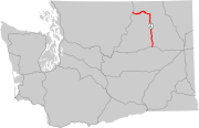
State Route 21 is a 191.34 miles (307.93 km) long state highway
in the U.S. state
of Washington that traverses four counties: Franklin, Adams, Lincoln and Ferry. The highway extends from an intersection with in Kahlotus
north through Lind
, Odessa
, Keller
, Republic
and Curlew
before becoming (BC 41) at the Canadian border in Danville
. SR 21 is concurrent
with (US 2) in Wilbur and in Republic and has two diamond interchange
s: at in Lind and (I-90) south of Odessa. Between Lincoln and Ferry counties, the roadway crosses Franklin D. Roosevelt Lake
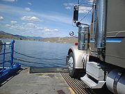
on the Keller Ferry, operated fare free by the Washington State Department of Transportation
(WSDOT) and the Department of Highways (DoH) since 1930.
Since 1899, at least one segment of the current highway has been in the state highway system. In 1899, the Marble Mount Road was established and later numbered in 1905 and renamed to the Sans Poil-Loomis Road in 1907. In 1915, a branch to the Canadian border was added to the highway, but was removed in 1923. In 1937, the Primary state highways were established and State Road 4 became (PSH 4), while the former Canadian branch became Secondary State Highway 4A (SSH 4A). Another highway, extending from Lind to Wilbur, became SSH 4B. In 1964, PSH 4 was split into SR 20 and SR 21 while SSH 2A and SSH 2B also became SR 21. In 1983, a road between Lind and Kahlotus became part of SR 21.
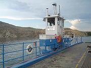
The Keller Ferry, which travels across the Columbia River
at Franklin D. Roosevelt Lake to connect the two segments of SR 21, was originally a cable ferry
operated in the early 1890s. J.C. Keller, founder of Keller, purchased the ferry in 1899 and traded ownership to Lincoln and Ferry counties in 1925. In 1929, the two counties unveiled a new eight-car cable ferry, named the Keller of Seattle, which served the two counties until 1930, when the predecessor of the current WSDOT, the DoH, purchased the ferry, but still operated Keller of Seattle until replacing it with the L.A. McLeod in 1939. In 1944, the Ann of Wilbur tugboat
and Sanpoil barge
acted as a ferry before a new replacement, the Martha S. was launched in 1948. The Martha S. has been in continual operation since 1948 and WSDOT planned to replace the ferry in the near future, but funding came $5.5 million US$ short. The ferry was suspended in early October 2009 after a leak was found in the hull of the Martha S.
, which is located in a narrow valley near several coulee
s in Franklin County. After leaving Kahlotus as the Lind–Kahlotus Road, the highway turns northeast and later west as it passes over the Sand Hills Coulee four times. Curving due north, the roadway leaves Franklin County to enter Adams County. Passing farmland in the flat landscape, SR 21 intersects and continues through an unnamed coulee to intersect Smart Road. Smart Road was the former alignment of SR 21 prior to the (US 395) interchange being built. SR 21 intersects US 395 in a diamond interchange
east of Downtown Lind
. From the interchange, the highway travels west and intersects Smart Road again before crossing over the Centennial Trail and entering Downtown Lind. In Downtown, the roadway is named Second, I and First Streets and serves as the main connector to other areas. After turning north to leave Lind, the road encounters the John Wayne Pioneer Trail
and more plains before intersecting the pre-interstate alignment of (I-90) and interchanging with I-90 at exit 206, another diamond interchange. North of the interchange, SR 21 travels through more plains and a coulee to leave Adams County and enter Lincoln County.
 In Lincoln County, the highway travels through farmland to encounter Odessa
as Division Street, intersecting . The roadway turns northwest at Pacific Lake and reverts back northwards into farmland. After temporarily turning east into more farmland, the road enters Wilbur
, named Bruce Avenue. In Wilbur, SR 21 turns west, concurrent
with , for 0.65 miles (1.05 km) before branching off north to intersect and leave Wilbur towards dense forests. North of Wilbur, the roadway approaches Speigle Canyon and makes several turns before exiting the canyon and nearing Franklin D. Roosevelt Lake
; at 80000 acres (323.75 km²), the lake is the largest in Washington. Paralleling the lake, the road then uses the Keller Ferry, a 80 feet (24.38 m) long boat used as a fare-free ferry across Franklin D. Roosevelt Lake, part of the Lake Roosevelt National Recreation Area
, operated by the Washington State Department of Transportation
(WSDOT) and its previous counterparts since 1930.
 The ferry travels across the Lincoln County line to enter Ferry County, named after Elisha P. Ferry
, the first Washington governor, southwest of Keller
in the Colville Indian Reservation
. Traveling northeast, between the Sanpoil River
and the southern end of the Okanagan Highlands, SR 21 passes Keller
and continues inland into the Columbia Mountains
on the banks
of the river. The river forms a canyon that the highway passes through and eventually both the river and road leave the Colville Indian Reservation. Shortly after leaving the reservation, the roadway enters Republic
and becomes concurrent with for 2.56 miles (4.12 km) before exiting the concurrency and Republic. Between Republic and the Canadian border, an estimated daily average of 1,600 motorists used this segment of SR 21, making this section the busiest. The daily average has declined since 2006 and 2007, when a daily average of 1,700 motorists utilized the segment. Northeast of Republic, the highway passes Curlew Lake
, the 123 acre (0.49776378 km²) Curlew Lake State Park
and the communities of Malo
and Curlew
. After passing through more dense forests, the roadway enters Danville
, where SR 21 crosses the Canadian border into British Columbia
as (BC 41). BC 41 continues 1.2 kilometre (0.745647283979768 mi) north to end at southwest of Grand Forks, BC
.
 SR 21 originated as the Marble Mount Road that extended from the north end of the Keller Ferry to Republic
and was established in 1899. The Marble Mount Road was later numbered in 1905 and renamed to the Sans Poil-Loomis Road in 1907. An extension of State Road 4 from Republic to the Canadian border existed from 1915 until 1923. When the Primary and secondary highway system was established in 1937, (PSH 4) replaced State Road 4 and was extended south from the Keller Ferry to Wilbur
. The Canadian border branch of State Road 4 that was deleted in 1923 was re-added as Secondary State Highway 4A (SSH 4A) and a highway extending south from Wilbur to Lind
became SSH 2B. All three roadways were later combined as SR 21 in a highway renumbering in 1964. In 1983, SR 21 was extended south to in Kahlotus
. Since 1983, the road has not been realigned with the exception of the (US 395) interchange in Lind. The speed limit
between Curlew Lake State Park
and the community of the same name
was temporarily lowered on 9 March 2009 to 35 miles per hour (56.3 km/h) due to cracks in the pavement. The speed limit was restored to 55 miles per hour (88.5 km/h) on 9 March.
 The Keller Ferry connects SR 21 between Lincoln and Ferry counties, which are separated by Franklin D. Roosevelt Lake
. The ferry originated as an oar-propelled canoe that was used by Native Americans prior to the late 19th century. In the early 1890s a four-car cable ferry
, owned and operated by Todd Clark and William Robertson, was established. After the town of Keller
was established north / upriver on the Sanpoil River
in 1898, J.C. Keller, the founder of the town, purchased the cable ferry in 1899. In 1925, Lincoln and Ferry counties jointly purchased Keller's ferry and in 1929 replaced the original ferry with an eight-car cable ferry that was later named Keller of Seattle. The Department of Highways (DoH), the predecessor to the modern-day Washington State Department of Transportation
(WSDOT), purchased the ferry on 1 September 1930 and ran it toll-free as it is today. The original location of the ferry was flooded between 1939 and 1940 after the damming of the Grand Coulee Dam
west / downriver on the Columbia River
created Franklin D. Roosevelt Lake. In July 1939, the L.A. McLeod was launched and replaced the earlier cable ferries. Between 1944 and 1948, the Ann of Wilbur, a tug boat, tugged the Sanpoil barge
that was used as a temporary replacement for the McLeod. On 9 September 1948, the Martha S. was launched and has been in continual operation since. Since the Martha S. is over seventy years old, the United States Coast Guard
requires that the ferry undergo a full drydock inspection every five years. As of 2009, WSDOT is $5.5 million US$ short of being able to replace the ferry. Design work has already been completed, but the ferry is not expected to be replaced yet. The Keller Ferry was repaired on 15 February 2007 to expand its lifespan; WSDOT detoured traffic onto . The Martha S. had a leak that was discovered in October 2009 and is suspended. Traffic has been detoured onto other highways. Ferry service resumed on 19 October, but one of the two engines overheated on 26 October, only one week later, and needs to be replaced, thus shutting down the ferry a second time during the same month.
State highways in Washington
In the U.S. state of Washington, the Washington State Department of Transportation maintains a network of over 7000 miles of state highways, including all Interstate and U.S. Highways that pass through the state. The system comprises 8.5% of the state's public road mileage, but carries over half...
in the U.S. state
U.S. state
A U.S. state is any one of the 50 federated states of the United States of America that share sovereignty with the federal government. Because of this shared sovereignty, an American is a citizen both of the federal entity and of his or her state of domicile. Four states use the official title of...
of Washington that traverses four counties: Franklin, Adams, Lincoln and Ferry. The highway extends from an intersection with in Kahlotus
Kahlotus, Washington
Kahlotus is a city in Franklin County, Washington, United States. The population was 193 at the 2010 census.-History:The first organized settlement of Kahlotus was by German immigrants, imported by the railroads, in around 1880. Among these settlers were several locally recognized pioneer...
north through Lind
Lind, Washington
Lind is a town in Adams County, Washington, United States. The population was 564 at the 2010 census, a 3.1% decrease over the preceding census.-History:...
, Odessa
Odessa, Washington
Odessa is a town in Lincoln County, Washington, United States. The population was 910 at the 2010 census.-History:George Finney first settled on the site of Odessa in 1886. He platted Odessa in the summer of 1899 after the Great Northern Railway had built its line through the valley in 1892...
, Keller
Keller, Washington
Keller is an unincorporated community in southeastern Ferry County in the northeastern part of the U.S. state of Washington.-History:The town is located in the San Poil Valley , and was founded in 1898 by John C. Keller, a local businessman...
, Republic
Republic, Washington
Republic is a city in Ferry County, Washington, United States. The population was 1,073 at the 2010 census, a 12.5% increase over the 2000 Census. It is the county seat of Ferry County.-History:...
and Curlew
Curlew, Washington
Curlew is an unincorporated community located in northwestern Ferry County, Washington, United States, between Malo and Danville on State Route 21. The BNSF Railway ran through the town. The historic Ansorge Hotel is located in Curlew.-Geography:...
before becoming (BC 41) at the Canadian border in Danville
Danville, Washington
Danville is an unincorporated community in Ferry County, Washington, United States. Danville is located on Washington State Route 21 near the Canadian border, north-northeast of Republic. Danville has a post office with ZIP code 99121...
. SR 21 is concurrent
Concurrency (road)
A concurrency, overlap, or coincidence in a road network is an instance of one physical road bearing two or more different highway, motorway, or other route numbers...
with (US 2) in Wilbur and in Republic and has two diamond interchange
Diamond interchange
A diamond interchange is a common type of road junction, used where a freeway crosses a minor road. The freeway itself is grade-separated from the minor road, one crossing the other over a bridge...
s: at in Lind and (I-90) south of Odessa. Between Lincoln and Ferry counties, the roadway crosses Franklin D. Roosevelt Lake
Franklin D. Roosevelt Lake
Franklin D. Roosevelt Lake is the reservoir created in 1941 by the impoundment of the Columbia River by the Grand Coulee Dam in Washington state. It is named for Franklin D. Roosevelt, who was President during the construction of the dam...
on the Keller Ferry, operated fare free by the Washington State Department of Transportation
Washington State Department of Transportation
The Washington State Department of Transportation , was established in 1905. The agency, led by a Secretary and overseen by the Governor, is a Washington governmental agency that constructs, maintains, and regulates the use of the state's transportation infrastructure...
(WSDOT) and the Department of Highways (DoH) since 1930.
Since 1899, at least one segment of the current highway has been in the state highway system. In 1899, the Marble Mount Road was established and later numbered in 1905 and renamed to the Sans Poil-Loomis Road in 1907. In 1915, a branch to the Canadian border was added to the highway, but was removed in 1923. In 1937, the Primary state highways were established and State Road 4 became (PSH 4), while the former Canadian branch became Secondary State Highway 4A (SSH 4A). Another highway, extending from Lind to Wilbur, became SSH 4B. In 1964, PSH 4 was split into SR 20 and SR 21 while SSH 2A and SSH 2B also became SR 21. In 1983, a road between Lind and Kahlotus became part of SR 21.
The Keller Ferry, which travels across the Columbia River
Columbia River
The Columbia River is the largest river in the Pacific Northwest region of North America. The river rises in the Rocky Mountains of British Columbia, Canada, flows northwest and then south into the U.S. state of Washington, then turns west to form most of the border between Washington and the state...
at Franklin D. Roosevelt Lake to connect the two segments of SR 21, was originally a cable ferry
Cable ferry
A cable ferry is guided and in many cases propelled across a river or other larger body of water by cables connected to both shores. They are also called chain ferries, floating bridges, or punts....
operated in the early 1890s. J.C. Keller, founder of Keller, purchased the ferry in 1899 and traded ownership to Lincoln and Ferry counties in 1925. In 1929, the two counties unveiled a new eight-car cable ferry, named the Keller of Seattle, which served the two counties until 1930, when the predecessor of the current WSDOT, the DoH, purchased the ferry, but still operated Keller of Seattle until replacing it with the L.A. McLeod in 1939. In 1944, the Ann of Wilbur tugboat
Tugboat
A tugboat is a boat that maneuvers vessels by pushing or towing them. Tugs move vessels that either should not move themselves, such as ships in a crowded harbor or a narrow canal,or those that cannot move by themselves, such as barges, disabled ships, or oil platforms. Tugboats are powerful for...
and Sanpoil barge
Barge
A barge is a flat-bottomed boat, built mainly for river and canal transport of heavy goods. Some barges are not self-propelled and need to be towed by tugboats or pushed by towboats...
acted as a ferry before a new replacement, the Martha S. was launched in 1948. The Martha S. has been in continual operation since 1948 and WSDOT planned to replace the ferry in the near future, but funding came $5.5 million US$ short. The ferry was suspended in early October 2009 after a leak was found in the hull of the Martha S.
Route description
SR 21 originates at an intersection with , about 0.28 mile (0.4506152 km) east of the northern terminus of ; both intersections are in the city of KahlotusKahlotus, Washington
Kahlotus is a city in Franklin County, Washington, United States. The population was 193 at the 2010 census.-History:The first organized settlement of Kahlotus was by German immigrants, imported by the railroads, in around 1880. Among these settlers were several locally recognized pioneer...
, which is located in a narrow valley near several coulee
Coulee
Coulee is applied rather loosely to different landforms, all of which refer to a kind of valley or drainage zone.The word coulee comes from the Canadian French coulée, from French word couler meaning "to flow"....
s in Franklin County. After leaving Kahlotus as the Lind–Kahlotus Road, the highway turns northeast and later west as it passes over the Sand Hills Coulee four times. Curving due north, the roadway leaves Franklin County to enter Adams County. Passing farmland in the flat landscape, SR 21 intersects and continues through an unnamed coulee to intersect Smart Road. Smart Road was the former alignment of SR 21 prior to the (US 395) interchange being built. SR 21 intersects US 395 in a diamond interchange
Diamond interchange
A diamond interchange is a common type of road junction, used where a freeway crosses a minor road. The freeway itself is grade-separated from the minor road, one crossing the other over a bridge...
east of Downtown Lind
Lind, Washington
Lind is a town in Adams County, Washington, United States. The population was 564 at the 2010 census, a 3.1% decrease over the preceding census.-History:...
. From the interchange, the highway travels west and intersects Smart Road again before crossing over the Centennial Trail and entering Downtown Lind. In Downtown, the roadway is named Second, I and First Streets and serves as the main connector to other areas. After turning north to leave Lind, the road encounters the John Wayne Pioneer Trail
John Wayne Pioneer Trail
The John Wayne Pioneer Trail follows the former roadbed of the Chicago, Milwaukee, St. Paul and Pacific Railroad for across two-thirds of Washington from the western slopes of the Cascade Mountains to the Idaho border. The Chicago, Milwaukee, St...
and more plains before intersecting the pre-interstate alignment of (I-90) and interchanging with I-90 at exit 206, another diamond interchange. North of the interchange, SR 21 travels through more plains and a coulee to leave Adams County and enter Lincoln County.
Odessa, Washington
Odessa is a town in Lincoln County, Washington, United States. The population was 910 at the 2010 census.-History:George Finney first settled on the site of Odessa in 1886. He platted Odessa in the summer of 1899 after the Great Northern Railway had built its line through the valley in 1892...
as Division Street, intersecting . The roadway turns northwest at Pacific Lake and reverts back northwards into farmland. After temporarily turning east into more farmland, the road enters Wilbur
Wilbur, Washington
Wilbur is a town in Lincoln County, Washington, United States. The population was 884 at the 2010 census.-History:Just prior to the construction of the Central Washington Railroad line in 1889, no towns existed west of Davenport in Lincoln County. One place along the line, "Wild Goose Bill's...
, named Bruce Avenue. In Wilbur, SR 21 turns west, concurrent
Concurrency (road)
A concurrency, overlap, or coincidence in a road network is an instance of one physical road bearing two or more different highway, motorway, or other route numbers...
with , for 0.65 miles (1.05 km) before branching off north to intersect and leave Wilbur towards dense forests. North of Wilbur, the roadway approaches Speigle Canyon and makes several turns before exiting the canyon and nearing Franklin D. Roosevelt Lake
Franklin D. Roosevelt Lake
Franklin D. Roosevelt Lake is the reservoir created in 1941 by the impoundment of the Columbia River by the Grand Coulee Dam in Washington state. It is named for Franklin D. Roosevelt, who was President during the construction of the dam...
; at 80000 acres (323.75 km²), the lake is the largest in Washington. Paralleling the lake, the road then uses the Keller Ferry, a 80 feet (24.38 m) long boat used as a fare-free ferry across Franklin D. Roosevelt Lake, part of the Lake Roosevelt National Recreation Area
Lake Roosevelt National Recreation Area
Lake Roosevelt National Recreation Area is a U.S. National Recreation Area of the National Park Service that encompasses the long Franklin D. Roosevelt Lake between Grand Coulee Dam and Northport, Washington, in eastern Washington state. It is a popular boating, fishing, hunting, camping, and...
, operated by the Washington State Department of Transportation
Washington State Department of Transportation
The Washington State Department of Transportation , was established in 1905. The agency, led by a Secretary and overseen by the Governor, is a Washington governmental agency that constructs, maintains, and regulates the use of the state's transportation infrastructure...
(WSDOT) and its previous counterparts since 1930.
Elisha P. Ferry
Elisha Peyre Ferry was the first Governor of the U.S. State of Washington. He had been the tenth governor of Washington Territory and became the first governor of Washington upon its admission into the Union on November 11, 1889. He served a single term, 1889-1893. He was a Republican. He served...
, the first Washington governor, southwest of Keller
Keller, Washington
Keller is an unincorporated community in southeastern Ferry County in the northeastern part of the U.S. state of Washington.-History:The town is located in the San Poil Valley , and was founded in 1898 by John C. Keller, a local businessman...
in the Colville Indian Reservation
Colville Indian Reservation
The Colville Indian Reservation is an Indian reservation in the north-central part of the U.S. state of Washington, inhabited and managed by the Confederated Tribes of the Colville Reservation, which is recognized by the United States of America as an American Indian Tribe...
. Traveling northeast, between the Sanpoil River
Sanpoil River
The Sanpoil River is a tributary of the Columbia River, in the U.S. state of Washington. The term Sanpoil is from the Okanagan term [snpʕʷílx], meaning "people of the gray country", or "gray as far as one can see".-Course:...
and the southern end of the Okanagan Highlands, SR 21 passes Keller
Keller, Washington
Keller is an unincorporated community in southeastern Ferry County in the northeastern part of the U.S. state of Washington.-History:The town is located in the San Poil Valley , and was founded in 1898 by John C. Keller, a local businessman...
and continues inland into the Columbia Mountains
Columbia Mountains
The Columbia Mountains are a group of mountain ranges located in southeastern British Columbia, and partially in Montana, Idaho and Washington. The mountain range covers 135,952 km² . The range is bounded by the Rocky Mountain Trench on the east, and the Kootenay River on the south; their...
on the banks
Bank (geography)
A geographic bank has four definitions and applications:# Limnology: The shoreline of a pond, swamp, estuary, reservoir, or lake. The grade can vary from vertical to a shallow slope....
of the river. The river forms a canyon that the highway passes through and eventually both the river and road leave the Colville Indian Reservation. Shortly after leaving the reservation, the roadway enters Republic
Republic, Washington
Republic is a city in Ferry County, Washington, United States. The population was 1,073 at the 2010 census, a 12.5% increase over the 2000 Census. It is the county seat of Ferry County.-History:...
and becomes concurrent with for 2.56 miles (4.12 km) before exiting the concurrency and Republic. Between Republic and the Canadian border, an estimated daily average of 1,600 motorists used this segment of SR 21, making this section the busiest. The daily average has declined since 2006 and 2007, when a daily average of 1,700 motorists utilized the segment. Northeast of Republic, the highway passes Curlew Lake
Curlew Lake (Washington)
Curlew Lake is a lake located in the glacier-carved Curlew Valley northeast of Republic, Washington. The spring- and stream-fed lake is named for the Long-billed Curlew, Numenius americanus, that once frequented the area. The seven mile long lake reaches a maximum of ⅓ miles wide and includes...
, the 123 acre (0.49776378 km²) Curlew Lake State Park
Curlew Lake State Park
Curlew Lake State Park in Ferry County, Washington is one of the Washington State Parks. It consists of on Curlew Lake not far from a public access paleontology site and an airfield...
and the communities of Malo
Malo, Washington
Malo is an unincorporated community in Ferry County, Washington, United States. Malo is located on Washington State Route 21 north-northeast of Republic. Malo has a post office with ZIP code 99150 and had a 2010 census population of 28....
and Curlew
Curlew, Washington
Curlew is an unincorporated community located in northwestern Ferry County, Washington, United States, between Malo and Danville on State Route 21. The BNSF Railway ran through the town. The historic Ansorge Hotel is located in Curlew.-Geography:...
. After passing through more dense forests, the roadway enters Danville
Danville, Washington
Danville is an unincorporated community in Ferry County, Washington, United States. Danville is located on Washington State Route 21 near the Canadian border, north-northeast of Republic. Danville has a post office with ZIP code 99121...
, where SR 21 crosses the Canadian border into British Columbia
British Columbia
British Columbia is the westernmost of Canada's provinces and is known for its natural beauty, as reflected in its Latin motto, Splendor sine occasu . Its name was chosen by Queen Victoria in 1858...
as (BC 41). BC 41 continues 1.2 kilometre (0.745647283979768 mi) north to end at southwest of Grand Forks, BC
Grand Forks, British Columbia
-Schools:Schools in the region are operated by School District 51 Boundary which has its main office in Grand Forks but also serves Midway, Greenwood, Beaverdell, and Rock Creek....
.
History
Republic, Washington
Republic is a city in Ferry County, Washington, United States. The population was 1,073 at the 2010 census, a 12.5% increase over the 2000 Census. It is the county seat of Ferry County.-History:...
and was established in 1899. The Marble Mount Road was later numbered in 1905 and renamed to the Sans Poil-Loomis Road in 1907. An extension of State Road 4 from Republic to the Canadian border existed from 1915 until 1923. When the Primary and secondary highway system was established in 1937, (PSH 4) replaced State Road 4 and was extended south from the Keller Ferry to Wilbur
Wilbur, Washington
Wilbur is a town in Lincoln County, Washington, United States. The population was 884 at the 2010 census.-History:Just prior to the construction of the Central Washington Railroad line in 1889, no towns existed west of Davenport in Lincoln County. One place along the line, "Wild Goose Bill's...
. The Canadian border branch of State Road 4 that was deleted in 1923 was re-added as Secondary State Highway 4A (SSH 4A) and a highway extending south from Wilbur to Lind
Lind, Washington
Lind is a town in Adams County, Washington, United States. The population was 564 at the 2010 census, a 3.1% decrease over the preceding census.-History:...
became SSH 2B. All three roadways were later combined as SR 21 in a highway renumbering in 1964. In 1983, SR 21 was extended south to in Kahlotus
Kahlotus, Washington
Kahlotus is a city in Franklin County, Washington, United States. The population was 193 at the 2010 census.-History:The first organized settlement of Kahlotus was by German immigrants, imported by the railroads, in around 1880. Among these settlers were several locally recognized pioneer...
. Since 1983, the road has not been realigned with the exception of the (US 395) interchange in Lind. The speed limit
Speed limit
Road speed limits are used in most countries to regulate the speed of road vehicles. Speed limits may define maximum , minimum or no speed limit and are normally indicated using a traffic sign...
between Curlew Lake State Park
Curlew Lake State Park
Curlew Lake State Park in Ferry County, Washington is one of the Washington State Parks. It consists of on Curlew Lake not far from a public access paleontology site and an airfield...
and the community of the same name
Curlew, Washington
Curlew is an unincorporated community located in northwestern Ferry County, Washington, United States, between Malo and Danville on State Route 21. The BNSF Railway ran through the town. The historic Ansorge Hotel is located in Curlew.-Geography:...
was temporarily lowered on 9 March 2009 to 35 miles per hour (56.3 km/h) due to cracks in the pavement. The speed limit was restored to 55 miles per hour (88.5 km/h) on 9 March.
Keller Ferry history
Franklin D. Roosevelt Lake
Franklin D. Roosevelt Lake is the reservoir created in 1941 by the impoundment of the Columbia River by the Grand Coulee Dam in Washington state. It is named for Franklin D. Roosevelt, who was President during the construction of the dam...
. The ferry originated as an oar-propelled canoe that was used by Native Americans prior to the late 19th century. In the early 1890s a four-car cable ferry
Cable ferry
A cable ferry is guided and in many cases propelled across a river or other larger body of water by cables connected to both shores. They are also called chain ferries, floating bridges, or punts....
, owned and operated by Todd Clark and William Robertson, was established. After the town of Keller
Keller, Washington
Keller is an unincorporated community in southeastern Ferry County in the northeastern part of the U.S. state of Washington.-History:The town is located in the San Poil Valley , and was founded in 1898 by John C. Keller, a local businessman...
was established north / upriver on the Sanpoil River
Sanpoil River
The Sanpoil River is a tributary of the Columbia River, in the U.S. state of Washington. The term Sanpoil is from the Okanagan term [snpʕʷílx], meaning "people of the gray country", or "gray as far as one can see".-Course:...
in 1898, J.C. Keller, the founder of the town, purchased the cable ferry in 1899. In 1925, Lincoln and Ferry counties jointly purchased Keller's ferry and in 1929 replaced the original ferry with an eight-car cable ferry that was later named Keller of Seattle. The Department of Highways (DoH), the predecessor to the modern-day Washington State Department of Transportation
Washington State Department of Transportation
The Washington State Department of Transportation , was established in 1905. The agency, led by a Secretary and overseen by the Governor, is a Washington governmental agency that constructs, maintains, and regulates the use of the state's transportation infrastructure...
(WSDOT), purchased the ferry on 1 September 1930 and ran it toll-free as it is today. The original location of the ferry was flooded between 1939 and 1940 after the damming of the Grand Coulee Dam
Grand Coulee Dam
Grand Coulee Dam is a gravity dam on the Columbia River in the U.S. state of Washington built to produce hydroelectric power and provide irrigation. It was constructed between 1933 and 1942, originally with two power plants. A third power station was completed in 1974 to increase its energy...
west / downriver on the Columbia River
Columbia River
The Columbia River is the largest river in the Pacific Northwest region of North America. The river rises in the Rocky Mountains of British Columbia, Canada, flows northwest and then south into the U.S. state of Washington, then turns west to form most of the border between Washington and the state...
created Franklin D. Roosevelt Lake. In July 1939, the L.A. McLeod was launched and replaced the earlier cable ferries. Between 1944 and 1948, the Ann of Wilbur, a tug boat, tugged the Sanpoil barge
Barge
A barge is a flat-bottomed boat, built mainly for river and canal transport of heavy goods. Some barges are not self-propelled and need to be towed by tugboats or pushed by towboats...
that was used as a temporary replacement for the McLeod. On 9 September 1948, the Martha S. was launched and has been in continual operation since. Since the Martha S. is over seventy years old, the United States Coast Guard
United States Coast Guard
The United States Coast Guard is a branch of the United States Armed Forces and one of the seven U.S. uniformed services. The Coast Guard is a maritime, military, multi-mission service unique among the military branches for having a maritime law enforcement mission and a federal regulatory agency...
requires that the ferry undergo a full drydock inspection every five years. As of 2009, WSDOT is $5.5 million US$ short of being able to replace the ferry. Design work has already been completed, but the ferry is not expected to be replaced yet. The Keller Ferry was repaired on 15 February 2007 to expand its lifespan; WSDOT detoured traffic onto . The Martha S. had a leak that was discovered in October 2009 and is suspended. Traffic has been detoured onto other highways. Ferry service resumed on 19 October, but one of the two engines overheated on 26 October, only one week later, and needs to be replaced, thus shutting down the ferry a second time during the same month.
Major intersections
| County | Location | Mile | Destinations | Notes |
|---|---|---|---|---|
| Franklin | Kahlotus Kahlotus, Washington Kahlotus is a city in Franklin County, Washington, United States. The population was 193 at the 2010 census.-History:The first organized settlement of Kahlotus was by German immigrants, imported by the railroads, in around 1880. Among these settlers were several locally recognized pioneer... |
0.00 | Southern terminus | |
| Adams | 11.64 | |||
| 22.14 | Smart Road | Former SR 21 | ||
| Lind Lind, Washington Lind is a town in Adams County, Washington, United States. The population was 564 at the 2010 census, a 3.1% decrease over the preceding census.-History:... |
24.48 | Interchange | ||
| 25.42 | Smart Road / Airport Road | Former SR 21 | ||
| 37.32 | Old | |||
| 37.80 | Interchange | |||
| Lincoln | Odessa Odessa, Washington Odessa is a town in Lincoln County, Washington, United States. The population was 910 at the 2010 census.-History:George Finney first settled on the site of Odessa in 1886. He platted Odessa in the summer of 1899 after the Great Northern Railway had built its line through the valley in 1892... |
55.83 | ||
| Wilbur Wilbur, Washington Wilbur is a town in Lincoln County, Washington, United States. The population was 884 at the 2010 census.-History:Just prior to the construction of the Central Washington Railroad line in 1889, no towns existed west of Davenport in Lincoln County. One place along the line, "Wild Goose Bill's... |
91.73 | Southern end of concurrency Concurrency (road) A concurrency, overlap, or coincidence in a road network is an instance of one physical road bearing two or more different highway, motorway, or other route numbers... |
||
| 92.38 | Northern end of concurrency | |||
| 92.90 | ||||
| 106.60 | Keller Ferry across Franklin D. Roosevelt Lake Franklin D. Roosevelt Lake Franklin D. Roosevelt Lake is the reservoir created in 1941 by the impoundment of the Columbia River by the Grand Coulee Dam in Washington state. It is named for Franklin D. Roosevelt, who was President during the construction of the dam... |
|||
| Ferry | Colville IR Colville Indian Reservation The Colville Indian Reservation is an Indian reservation in the north-central part of the U.S. state of Washington, inhabited and managed by the Confederated Tribes of the Colville Reservation, which is recognized by the United States of America as an American Indian Tribe... |
|||
| Republic Republic, Washington Republic is a city in Ferry County, Washington, United States. The population was 1,073 at the 2010 census, a 12.5% increase over the 2000 Census. It is the county seat of Ferry County.-History:... |
160.05 | Southern end of concurrency | ||
| 162.61 | Northern end of concurrency | |||
| 191.34 | Canada – United States border | Northern terminus; continues as British Columbia Highway 41 | ||