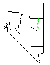
Steptoe Valley
Encyclopedia

White Pine County, Nevada
White Pine County is a county located in the U.S. state of Nevada. Its population at the 2010 census was 10,030. Its county seat is Ely. It is the home of Great Basin National Park...
, in northeastern Nevada
Nevada
Nevada is a state in the western, mountain west, and southwestern regions of the United States. With an area of and a population of about 2.7 million, it is the 7th-largest and 35th-most populous state. Over two-thirds of Nevada's people live in the Las Vegas metropolitan area, which contains its...
in the western United States
United States
The United States of America is a federal constitutional republic comprising fifty states and a federal district...
. From the historic community of Currie
Currie, Nevada
Currie is an unincorporated community in Elko County, Nevada, United States. It is often considered a ghost town, and its population is around 20....
, the valley runs south for approximately 100 miles (160 km). To the west are the high Egan Range
Egan Range
The Egan Range is a line of mountains in White Pine County, in eastern Nevada in the western United States. From Egan Creek near the historic community of Cherry Creek, the range runs south for approximately 108 miles , extending into the northern part of Lincoln County. To the east are the large...
and the Cherry Creek Range
Cherry Creek Range
The Cherry Creek Range is a line of mountains, Basin and Range faulted, in northern White Pine and southern Elko Counties, in northeastern Nevada in the western United States. The range runs generally north-south for approximately 50 miles...
, while to the east is the even higher Schell Creek Range
Schell Creek Range
The Schell Creek Range is a linear mountain range in central White Pine County, in east-central Nevada. Its length is approximately in a north-south direction....
. U.S. Route 93 passes through much of the northern section of the valley, past the historic mining town of Cherry Creek
Cherry Creek, Nevada
Cherry Creek is a historic community located in northern White Pine County, in northeastern Nevada in the western United States. It is a census county division , with a population at the 2010 census of 72....
and the communities of McGill
McGill, Nevada
McGill is a census-designated place in White Pine County, Nevada, United States. The population was 1,148 at the 2010 census.-Geography:McGill is located at ....
and Ely
Ely, Nevada
Ely is the largest city and county seat of White Pine County, Nevada, United States. Ely was founded as a stagecoach station along the Pony Express and Central Overland Route. Ely's mining boom came later than the other towns along US 50, with the discovery of copper in 1906...
, before crossing the Schell Creek Range at Connors Pass. Also found in this valley are the Ward Charcoal Ovens State Historic Park
Ward Charcoal Ovens State Historic Park
Ward Charcoal Ovens State Historic Park State Park is a Nevada state park in White Pine County, Nevada. Located 20 miles south of the town of Ely, it is in the Eastern Nevada Region of Nevada State Parks....
, the Steptoe Valley Wildlife Management Area, and Cave Lake State Park
Cave Lake State Park
Cave Lake State Park is a state park of Nevada, USA, featuring a reservoir in White Pine County. Located about east of the town of Ely, Cave Lake is situated at an elevation of within the northern section of the Schell Creek Range...
. At Egan Canyon and Schellbourne Pass (near Cherry Creek), the Overland Stage Line
George Chorpenning
George W. Chorpenning Jr. was a pioneer in the transportation of mail, freight, and passengers through the arid and undeveloped western regions of the United States...
and the subsequent Pony Express
Pony Express
The Pony Express was a fast mail service crossing the Great Plains, the Rocky Mountains, and the High Sierra from St. Joseph, Missouri, to Sacramento, California, from April 3, 1860 to October 1861...
and Transcontinental Telegraph
First Transcontinental Telegraph
The First Transcontinental Telegraph was a milestone in electrical engineering and in the formation of the United States of America. It served as the only method of near-instantaneous communication between the east and west coasts during the 1860s....
made their way through the mountains of central Nevada in the 1860s.
The valley is named after Colonel Edward Steptoe
Edward Steptoe
Edward Jenner Steptoe was an officer in the United States Army who served in the Mexican-American War and the Indian Wars. He is primarily remembered for his defeat at the Battle of Pine Creek during the Spokane-Coeur d'Alene-Paloos War. It was at Pine Creek where Steptoe and 164 men were ambushed...
, who explored the region in 1854.

