Stopham
Encyclopedia
Stopham is a hamlet
and civil parish
in the District of Chichester
in West Sussex
, England
located two kilometres (1.4 miles) west of Pulborough
on the A283 road.
The parish has a land area of 354 hectares (874 acres). In the 2001 census 87 people lived in 39 households, of whom 40 were economically active.
Stopham has an Anglo-Saxon
Anglican church, dedicated to St. Mary the Virgin, located a few hundred metres north of the A283 road together with an ancient Manor house
. The parish is bounded to the east by the River Arun
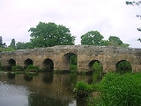
, crossed by Stopham bridge built in 1423. The River Rother
forms the southern boundary of the parish from its confluence with the Arun below Stopham Bridge. In the 1790s the Rother was made navigable to Midhurst
beginning with a canal cut from the Arun between the Rother and the A283 road. The first lock was built in the grounds of Stopham House. Stopham or Stopeham is recorded in the Domesday Book
and has belonged to the same family, the Bartletts or Barttelots since the Norman Conquest. Since 1875 they have been baronets
.
Hamlet (place)
A hamlet is usually a rural settlement which is too small to be considered a village, though sometimes the word is used for a different sort of community. Historically, when a hamlet became large enough to justify building a church, it was then classified as a village...
and civil parish
Civil parish
In England, a civil parish is a territorial designation and, where they are found, the lowest tier of local government below districts and counties...
in the District of Chichester
Chichester (district)
Chichester is a largely rural local government district in West Sussex, England. Its council is based in the city of Chichester.-History:The district was formed on 1 April 1974, under the Local Government Act 1972, as a merger of the municipal borough of Chichester and the Rural Districts of...
in West Sussex
West Sussex
West Sussex is a county in the south of England, bordering onto East Sussex , Hampshire and Surrey. The county of Sussex has been divided into East and West since the 12th century, and obtained separate county councils in 1888, but it remained a single ceremonial county until 1974 and the coming...
, England
England
England is a country that is part of the United Kingdom. It shares land borders with Scotland to the north and Wales to the west; the Irish Sea is to the north west, the Celtic Sea to the south west, with the North Sea to the east and the English Channel to the south separating it from continental...
located two kilometres (1.4 miles) west of Pulborough
Pulborough
Pulborough is a large village and civil parish in the Horsham district of West Sussex, England, with some 5,000 inhabitants. It is located almost centrally within West Sussex and is south west of London. It is at the junction of the north-south A29 and the east-west roads.The village is near the...
on the A283 road.
The parish has a land area of 354 hectares (874 acres). In the 2001 census 87 people lived in 39 households, of whom 40 were economically active.
Stopham has an Anglo-Saxon
Anglo-Saxon architecture
Anglo-Saxon architecture was a period in the history of architecture in England, and parts of Wales, from the mid-5th century until the Norman Conquest of 1066. Anglo-Saxon secular buildings in Britain were generally simple, constructed mainly using timber with thatch for roofing...
Anglican church, dedicated to St. Mary the Virgin, located a few hundred metres north of the A283 road together with an ancient Manor house
Manorialism
Manorialism, an essential element of feudal society, was the organizing principle of rural economy that originated in the villa system of the Late Roman Empire, was widely practiced in medieval western and parts of central Europe, and was slowly replaced by the advent of a money-based market...
. The parish is bounded to the east by the River Arun
River Arun
The Arun is a river in the English county of West Sussex. Its source is a series of small streams in the St Leonard's Forest area, to the east of Horsham...
, crossed by Stopham bridge built in 1423. The River Rother
River Rother (Western)
The River Rother is a river which flows for thirty miles from Empshott in Hampshire to Stopham in West Sussex, where it joins the River Arun. It should not be confused with the River Rother, in East Sussex....
forms the southern boundary of the parish from its confluence with the Arun below Stopham Bridge. In the 1790s the Rother was made navigable to Midhurst
Midhurst
Midhurst is a market town and civil parish in the Chichester district of West Sussex, England, with a population of 4,889 in 2001. The town is situated on the River Rother and is home to the ruin of the Tudor Cowdray House and the stately Victorian Cowdray Park...
beginning with a canal cut from the Arun between the Rother and the A283 road. The first lock was built in the grounds of Stopham House. Stopham or Stopeham is recorded in the Domesday Book
Domesday Book
Domesday Book , now held at The National Archives, Kew, Richmond upon Thames in South West London, is the record of the great survey of much of England and parts of Wales completed in 1086...
and has belonged to the same family, the Bartletts or Barttelots since the Norman Conquest. Since 1875 they have been baronets
Barttelot Baronets
The Barttelot Baronetcy, of Stopham in the County of West Sussex, is a title in the Baronetage of the United Kingdom. It was created on 14 June 1875 for the Conservative politician Walter Barttelot...
.
External links
- Stopham Church
- Bartlett Family History
- Stopham Ancient Bridge
- P A L Vine, London's Lost Route to Midhurst The Earl of Egremont's Navigation

