

Streets Run
Encyclopedia
Streets Run is a 5.2 miles (8.4 km) tributary of the Monongahela River
in Allegheny County, Pennsylvania
. This urban stream
drains portions of the communities of Pittsburgh, Baldwin
, Brentwood
, West Mifflin
and Whitehall
, an area of about ten square miles.
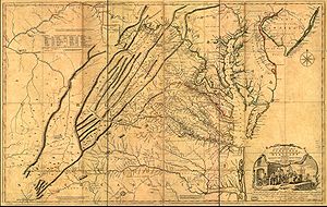 Streets Run, previously referred to as Licking Creek, is depicted in A map of the most inhabited part of Virginia
containing the whole province of Maryland
with part of Pensilvania
, New Jersey
and North Carolina
, drawn by Joshua Fry
and Peter Jefferson
in 1751, and published by Thos. Jefferys, London, 1755. This landmark map, unusual in that it relied on firsthand surveys, is the first correct depiction of the Allegheny Mountains
, complete with "The Great Road from the Yadkin River
thro Virgionia to Philadelphia distant 455 Miles" - an accurate survey of what would come to be styled the Great Philadelphia Wagon Road
.
began mining coal along Streets Run in 1828. Other coal mines in the watershed were run by the I.D. Risher and Daniel W Risher Companies, as well as the Harrison Gas Coal Company.
ran along Sreets Run to service the mine developed by J.H. Hays. It ended at Six Mile Ferry, on the Monongahela. The Pittsburgh Southern Railroad
and its successor, the Baltimore and Ohio Railroad
, also had lines running though the valley. The Whitehall Tunnel
connects this valley with the Peters Creek
watershed.
Monongahela River
The Monongahela River is a river on the Allegheny Plateau in north-central West Virginia and southwestern Pennsylvania in the United States...
in Allegheny County, Pennsylvania
Allegheny County, Pennsylvania
Allegheny County is a county in the southwestern part of the U.S. state of Pennsylvania. As of the 2010 census, the population was 1,223,348; making it the second most populous county in Pennsylvania, following Philadelphia County. The county seat is Pittsburgh...
. This urban stream
Urban stream
An urban stream is a formerly natural waterway that flows through a heavily populated area. Urban streams are often significantly polluted, due to urban runoff and combined sewer outflows....
drains portions of the communities of Pittsburgh, Baldwin
Baldwin, Pennsylvania
Baldwin is a borough in Allegheny County, Pennsylvania, United States, and is part of the Pittsburgh Metro Area. The population was 19,767 at the 2010 census.-Geography:...
, Brentwood
Brentwood, Pennsylvania
Brentwood is a borough in Allegheny County, Pennsylvania, United States, and is part of the Pittsburgh Metro Area. The population was 9,643 at the 2010 census.-Geography and climate:Brentwood is located at ....
, West Mifflin
West Mifflin, Pennsylvania
West Mifflin is a borough in Allegheny County, Pennsylvania, United States, located southeast of downtown Pittsburgh. The population was 20,313 at the 2010 census....
and Whitehall
Whitehall, Allegheny County, Pennsylvania
Whitehall is a borough in Allegheny County, Pennsylvania, United States. The population was 13,944 at the 2010 census.-History:The Whitehall is probably named after Silas D. Prior's tavern on Brownsville Road, which was re-named White Hall in the 1850s...
, an area of about ten square miles.
Colonial history
Virginia
The Commonwealth of Virginia , is a U.S. state on the Atlantic Coast of the Southern United States. Virginia is nicknamed the "Old Dominion" and sometimes the "Mother of Presidents" after the eight U.S. presidents born there...
containing the whole province of Maryland
Maryland
Maryland is a U.S. state located in the Mid Atlantic region of the United States, bordering Virginia, West Virginia, and the District of Columbia to its south and west; Pennsylvania to its north; and Delaware to its east...
with part of Pensilvania
Pennsylvania
The Commonwealth of Pennsylvania is a U.S. state that is located in the Northeastern and Mid-Atlantic regions of the United States. The state borders Delaware and Maryland to the south, West Virginia to the southwest, Ohio to the west, New York and Ontario, Canada, to the north, and New Jersey to...
, New Jersey
New Jersey
New Jersey is a state in the Northeastern and Middle Atlantic regions of the United States. , its population was 8,791,894. It is bordered on the north and east by the state of New York, on the southeast and south by the Atlantic Ocean, on the west by Pennsylvania and on the southwest by Delaware...
and North Carolina
North Carolina
North Carolina is a state located in the southeastern United States. The state borders South Carolina and Georgia to the south, Tennessee to the west and Virginia to the north. North Carolina contains 100 counties. Its capital is Raleigh, and its largest city is Charlotte...
, drawn by Joshua Fry
Joshua Fry
Colonel Joshua Fry was a surveyor, adventurer, mapmaker, soldier, and member of the House of Burgesses, the legislature of the colony of Virginia...
and Peter Jefferson
Peter Jefferson
Peter Jefferson was the father of American President Thomas Jefferson . A surveyor and cartographer, his Fry-Jefferson Map of 1751 accurately depicted the Allegheny Mountains for the first time and showed the route of "The Great Road from the Yadkin River thro Virginia to Philadelphia distant 455...
in 1751, and published by Thos. Jefferys, London, 1755. This landmark map, unusual in that it relied on firsthand surveys, is the first correct depiction of the Allegheny Mountains
Allegheny Mountains
The Allegheny Mountain Range , also spelled Alleghany, Allegany and, informally, the Alleghenies, is part of the vast Appalachian Mountain Range of the eastern United States and Canada...
, complete with "The Great Road from the Yadkin River
Yadkin River
The Yadkin River is one of the longest rivers in North Carolina, flowing . It rises in the northwestern portion of the state near the Blue Ridge Parkway's Thunder Hill Overlook. Several parts of the river are impounded by dams for water, power, and flood control. The river becomes the Pee Dee...
thro Virgionia to Philadelphia distant 455 Miles" - an accurate survey of what would come to be styled the Great Philadelphia Wagon Road
Great Wagon Road
The Great Wagon Road was a colonial American improved trail transiting the Great Appalachian Valley from Pennsylvania to North Carolina, and from there to Georgia....
.
Mining history
James Hardin HaysJames H. Hays (coal operator)
James Harden Hays was a pioneer of bituminous coal mining in Western Pennsylvania. His first mine was opened in 1828, at the mouth of Street's Run, where it empties into the Monongahela River. He died on March 30, 1876, at his home near Beck's Run....
began mining coal along Streets Run in 1828. Other coal mines in the watershed were run by the I.D. Risher and Daniel W Risher Companies, as well as the Harrison Gas Coal Company.
Railroad history
The H.B. Hays and Brothers Coal RailroadH.B. Hays and Brothers Coal Railroad
The H.B. Hays and Brothers Coal Railroad was a narrow gauge railroad operated to carry coal from the Hays family mines along Becks Run and Streets Run in Allegheny County, Pennsylvania. Both branches included an incline, and both are visible in the engravings below, one just south of Six Mile...
ran along Sreets Run to service the mine developed by J.H. Hays. It ended at Six Mile Ferry, on the Monongahela. The Pittsburgh Southern Railroad
and its successor, the Baltimore and Ohio Railroad
Baltimore and Ohio Railroad
The Baltimore and Ohio Railroad was one of the oldest railroads in the United States and the first common carrier railroad. It came into being mostly because the city of Baltimore wanted to compete with the newly constructed Erie Canal and another canal being proposed by Pennsylvania, which...
, also had lines running though the valley. The Whitehall Tunnel
Whitehall Tunnel
The Whitehall Tunnel in Allegheny County, Pennsylvania was originally built by the B&O Railroad in 1899 as a double-track tunnel. The tunnel was completed in 1900....
connects this valley with the Peters Creek
Peters Creek (Pennsylvania)
Peters Creek is a tributary of the Monongahela River and part of the Mississippi River watershed, flowing through southwestern Pennsylvania in the United States....
watershed.