
Sugar Hill, New Hampshire
Encyclopedia
Sugar Hill is a town in Grafton County
, New Hampshire
, United States
. The population was 563 at the 2010 census. Sugar Hill is a venerable resort community which overlooks the White Mountain National Forest
, with views of the Presidential
, Franconia
, Kinsman
and Dalton ranges.
in Carroll County
incorporated as a town in 2001) . After considerable litigation, it was carved out of Lisbon
to be an independent voting unit. The name Sugar Hill comes from a large grove
of sugar maple
s in the hills.
With clean air and panoramic views from atop Sunset Hill Ridge of both the White Mountains
and Green Mountains
, the community became a fashionable Victorian
resort. First attracted by paintings of White Mountain art
ists, the wealthy arrived by train
to escape the heat, humidity and pollution of summers in Boston, Hartford
, New York
and Philadelphia
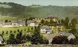
. Several hostelries were built, including the Hotel Lookoff. But the grandest was the Sunset Hill House, built in 1880 after rail service arrived in neighboring Lisbon Village (Sunset Hill Station). With the longest porch on a single side in New Hampshire, the Second Empire hotel accommodated 350 guests and 300 staff. Patrons found amusement in the casino, bowling alley, or on carriage
rides touring nearby Franconia Notch
. Built in 1897, the 9-hole Sugar Hill House Golf Course, together with its 1900 clubhouse, are the oldest in the state and today listed on the National Register
. Bobby Jones
played the links
.
With the advent of automobiles came a decline in grand hotels, however, as tourists were no longer restricted by the limits of rail service. The Sunset Hill House remained open until 1973, longer than many of its type in the region. But it closed at season's end, when the furnishings were sold at auction. The aging structure was demolished in 1974, although its annex survived and now operates as an inn of the same name.
The first resort-based ski school
in the U.S. was opened at Sugar Hill in 1929 by Katharine "Kate" Peckett with her husband, Austria
n ski
instructor Sig Buchmayer, both important figures in the history of skiing
. The same year, organized ski trains from Boston began running to the White Mountains.
, the town has a total area of 17.2 square miles (44.5 km²), of which 17 square miles (44 km²) is land and 0.2 square mile (0.517997622 km²) is water, comprising 1.06% of the town. Sugar Hill is drained by the Gale River
and other tributaries of the Ammonoosuc River
. The town is crossed by New Hampshire Route 117
. Interstate 93
and New Hampshire Route 18
pass through the northeast corner of the town. The highest point in town is the summit of Bronson Hill, at 2078 feet (633.4 m) above sea level
.
of 2000, there were 563 people, 258 households, and 164 families residing in the town. The population density
was 32.9 people per square mile (12.7/km²). There were 385 housing units at an average density of 22.5 per square mile (8.7/km²). The racial makeup of the town was 98.40% White, 1.24% Asian, and 0.36% from two or more races. Hispanic or Latino of any race were 0.18% of the population.
There were 258 households out of which 22.1% had children under the age of 18 living with them, 56.2% were married couples
living together, 4.7% had a female householder with no husband present, and 36.4% were non-families. 29.8% of all households were made up of individuals and 12.0% had someone living alone who was 65 years of age or older. The average household size was 2.18 and the average family size was 2.72.
In the town the population was spread out with 18.1% under the age of 18, 5.3% from 18 to 24, 24.2% from 25 to 44, 33.7% from 45 to 64, and 18.7% who were 65 years of age or older. The median age was 46 years. For every 100 females there were 98.9 males. For every 100 females age 18 and over, there were 101.3 males.
The median income for a household in the town was $49,219, and the median income for a family was $60,288. Males had a median income of $36,667 versus $25,714 for females. The per capita income
for the town was $29,743. About 4.3% of families and 5.3% of the population were below the poverty line, including none of those under age 18 and 10.6% of those age 65 or over.
Grafton County, New Hampshire
Grafton County is a county located in the U.S. state of New Hampshire. As of the 2010 census, the population was 89,118. Its county seat is North Haverhill, which is a village within the town of Haverhill. Until 1972, the county courthouse and other offices were located in downtown Woodsville, a...
, New Hampshire
New Hampshire
New Hampshire is a state in the New England region of the northeastern United States of America. The state was named after the southern English county of Hampshire. It is bordered by Massachusetts to the south, Vermont to the west, Maine and the Atlantic Ocean to the east, and the Canadian...
, United States
United States
The United States of America is a federal constitutional republic comprising fifty states and a federal district...
. The population was 563 at the 2010 census. Sugar Hill is a venerable resort community which overlooks the White Mountain National Forest
White Mountain National Forest
The White Mountain National Forest is a federally-managed forest contained within the White Mountains in the northeastern United States. It was established in 1918 as a result of the Weeks Act of 1911; federal acquisition of land had already begun in 1914. It has a total area of...
, with views of the Presidential
Presidential Range
The Presidential Range is a mountain range located in the White Mountains of the U.S. state of New Hampshire. Containing the highest peaks of the Whites, its most notable summits are named for American Presidents, followed by prominent public figures of the 18th and 19th centuries.Mt...
, Franconia
Franconia Range
The Franconia Range is a mountain range located in the White Mountains of the U.S. state of New Hampshire. It is the second-highest range of peaks in the White Mountains....
, Kinsman
Kinsman Mountain
Kinsman Mountain is a mountain located in Grafton County, New Hampshire. The mountain is named after Nathan Kinsman, an early resident of Easton, New Hampshire, and is part of the Kinsman Range of the White Mountains...
and Dalton ranges.
History
This town is New Hampshire's second youngest, having incorporated in 1962 (Hart's LocationHart's Location, New Hampshire
Hart's Location is a town in Carroll County, New Hampshire, United States. Since 1948, the town has been one of the first places to declare its results for the New Hampshire Presidential primary and U.S. Presidential elections....
in Carroll County
Carroll County, New Hampshire
-Demographics:As of the census of 2000, there were 43,666 people, 18,351 households, and 12,313 families residing in the county. The population density was 18/km² . There were 34,750 housing units at an average density of 14/km²...
incorporated as a town in 2001) . After considerable litigation, it was carved out of Lisbon
Lisbon, New Hampshire
Lisbon is a town in Grafton County, New Hampshire, United States. The population was 1,595 at the 2010 census. Lisbon hosts an annual "Lilac Festival" on Memorial Day weekend....
to be an independent voting unit. The name Sugar Hill comes from a large grove
Grove (nature)
A grove is a small group of trees with minimal or no undergrowth, such as a sequoia grove, or a small orchard planted for the cultivation of fruits or nuts...
of sugar maple
Sugar Maple
Acer saccharum is a species of maple native to the hardwood forests of northeastern North America, from Nova Scotia west to southern Ontario, and south to Georgia and Texas...
s in the hills.
With clean air and panoramic views from atop Sunset Hill Ridge of both the White Mountains
White Mountains (New Hampshire)
The White Mountains are a mountain range covering about a quarter of the state of New Hampshire and a small portion of western Maine in the United States. Part of the Appalachian Mountains, they are considered the most rugged mountains in New England...
and Green Mountains
Green Mountains
The Green Mountains are a mountain range in the U.S. state of Vermont. The range extends approximately .-Peaks:The most notable mountains in the range include:*Mount Mansfield, , the highest point in Vermont*Killington Peak, *Mount Ellen,...
, the community became a fashionable Victorian
Victorian architecture
The term Victorian architecture refers collectively to several architectural styles employed predominantly during the middle and late 19th century. The period that it indicates may slightly overlap the actual reign, 20 June 1837 – 22 January 1901, of Queen Victoria. This represents the British and...
resort. First attracted by paintings of White Mountain art
White Mountain art
White Mountain art is the body of work created during the 19th century by over four hundred artists who painted landscape scenes of the White Mountains of New Hampshire in order to promote the region and, consequently, sell their works of art....
ists, the wealthy arrived by train
Train
A train is a connected series of vehicles for rail transport that move along a track to transport cargo or passengers from one place to another place. The track usually consists of two rails, but might also be a monorail or maglev guideway.Propulsion for the train is provided by a separate...
to escape the heat, humidity and pollution of summers in Boston, Hartford
Hartford, Connecticut
Hartford is the capital of the U.S. state of Connecticut. The seat of Hartford County until Connecticut disbanded county government in 1960, it is the second most populous city on New England's largest river, the Connecticut River. As of the 2010 Census, Hartford's population was 124,775, making...
, New York
New York City
New York is the most populous city in the United States and the center of the New York Metropolitan Area, one of the most populous metropolitan areas in the world. New York exerts a significant impact upon global commerce, finance, media, art, fashion, research, technology, education, and...
and Philadelphia
Philadelphia, Pennsylvania
Philadelphia is the largest city in the Commonwealth of Pennsylvania and the county seat of Philadelphia County, with which it is coterminous. The city is located in the Northeastern United States along the Delaware and Schuylkill rivers. It is the fifth-most-populous city in the United States,...
. Several hostelries were built, including the Hotel Lookoff. But the grandest was the Sunset Hill House, built in 1880 after rail service arrived in neighboring Lisbon Village (Sunset Hill Station). With the longest porch on a single side in New Hampshire, the Second Empire hotel accommodated 350 guests and 300 staff. Patrons found amusement in the casino, bowling alley, or on carriage
Carriage
A carriage is a wheeled vehicle for people, usually horse-drawn; litters and sedan chairs are excluded, since they are wheelless vehicles. The carriage is especially designed for private passenger use and for comfort or elegance, though some are also used to transport goods. It may be light,...
rides touring nearby Franconia Notch
Franconia Notch
Franconia Notch is a major mountain pass through the White Mountains of New Hampshire. Dominated by Cannon Mountain, it lies principally within Franconia Notch State Park and is traversed by the Franconia Notch Parkway Franconia Notch (el. 1950 ft. / 590 m.) is a major mountain pass through...
. Built in 1897, the 9-hole Sugar Hill House Golf Course, together with its 1900 clubhouse, are the oldest in the state and today listed on the National Register
National Register of Historic Places
The National Register of Historic Places is the United States government's official list of districts, sites, buildings, structures, and objects deemed worthy of preservation...
. Bobby Jones
Bobby Jones (golfer)
Robert Tyre "Bobby" Jones Jr. was an American amateur golfer, and a lawyer by profession. Jones was the most successful amateur golfer ever to compete on a national and international level...
played the links
Links (golf)
A links is the oldest style of golf course, first developed in Scotland. The word "links" comes from the Scots language and refers to an area of coastal sand dunes and sometimes to open parkland. It also retains this more general meaning in the Scottish English dialect...
.
With the advent of automobiles came a decline in grand hotels, however, as tourists were no longer restricted by the limits of rail service. The Sunset Hill House remained open until 1973, longer than many of its type in the region. But it closed at season's end, when the furnishings were sold at auction. The aging structure was demolished in 1974, although its annex survived and now operates as an inn of the same name.
The first resort-based ski school
Ski school
A ski school is an establishment that trains skiers. The modern version of the ski school was invented by the Austrian ski pioneer Hannes Schneider in the early 1920s when he formalized instruction methods and established these methods as teaching principles for all ski instructors at his school.In...
in the U.S. was opened at Sugar Hill in 1929 by Katharine "Kate" Peckett with her husband, Austria
Austria
Austria , officially the Republic of Austria , is a landlocked country of roughly 8.4 million people in Central Europe. It is bordered by the Czech Republic and Germany to the north, Slovakia and Hungary to the east, Slovenia and Italy to the south, and Switzerland and Liechtenstein to the...
n ski
Alpine skiing
Alpine skiing is the sport of sliding down snow-covered hills on skis with fixed-heel bindings. Alpine skiing can be contrasted with skiing using free-heel bindings: Ski mountaineering and nordic skiing – such as cross-country; ski jumping; and Telemark. In competitive alpine skiing races four...
instructor Sig Buchmayer, both important figures in the history of skiing
History of skiing
Skiing, or traveling over snow on wooden runners, has a recorded history of almost five millennia.- Ancient history :The first hints to the existence of skis are on 4500 to 5000 year old rock drawings, e.g. at Rødøy in Norway or at Steinkjer , which depict a man on skis holding a stick...
. The same year, organized ski trains from Boston began running to the White Mountains.
Geography
According to the United States Census BureauUnited States Census Bureau
The United States Census Bureau is the government agency that is responsible for the United States Census. It also gathers other national demographic and economic data...
, the town has a total area of 17.2 square miles (44.5 km²), of which 17 square miles (44 km²) is land and 0.2 square mile (0.517997622 km²) is water, comprising 1.06% of the town. Sugar Hill is drained by the Gale River
Gale River
The Gale River is a 13.1 mile long tributary of the Ammonoosuc River in northwestern New Hampshire in the United States. Via the Ammonoosuc, it is part of the watershed of the Connecticut River, which flows to Long Island Sound....
and other tributaries of the Ammonoosuc River
Ammonoosuc River
The Ammonoosuc River is a river, 55 mi long, in northwestern New Hampshire in the United States. It is a tributary of the Connecticut River, which flows to Long Island Sound. "Ammonoosuc" is Abnaki for "small, narrow fishing place"....
. The town is crossed by New Hampshire Route 117
New Hampshire Route 117
New Hampshire Route 117 is an long east–west highway in northern New Hampshire. NH 117 runs from Franconia to Lisbon in the White Mountains Region....
. Interstate 93
Interstate 93
Interstate 93 is an Interstate Highway in the New England section of the United States. Its southern terminus is in Canton, Massachusetts, in the Boston metropolitan area, at Interstate 95; its northern terminus is near St. Johnsbury, Vermont, at Interstate 91...
and New Hampshire Route 18
New Hampshire Route 18
New Hampshire Route 18 is a long north–south state highway in New Hampshire. Its northern terminus is at the Vermont state line in the town of Littleton, where the road continues north as Vermont Route 18. The southern terminus of NH 18 is at an interchange with Interstate 93 and U.S...
pass through the northeast corner of the town. The highest point in town is the summit of Bronson Hill, at 2078 feet (633.4 m) above sea level
Sea level
Mean sea level is a measure of the average height of the ocean's surface ; used as a standard in reckoning land elevation...
.
Demographics
As of the censusCensus
A census is the procedure of systematically acquiring and recording information about the members of a given population. It is a regularly occurring and official count of a particular population. The term is used mostly in connection with national population and housing censuses; other common...
of 2000, there were 563 people, 258 households, and 164 families residing in the town. The population density
Population density
Population density is a measurement of population per unit area or unit volume. It is frequently applied to living organisms, and particularly to humans...
was 32.9 people per square mile (12.7/km²). There were 385 housing units at an average density of 22.5 per square mile (8.7/km²). The racial makeup of the town was 98.40% White, 1.24% Asian, and 0.36% from two or more races. Hispanic or Latino of any race were 0.18% of the population.
There were 258 households out of which 22.1% had children under the age of 18 living with them, 56.2% were married couples
Marriage
Marriage is a social union or legal contract between people that creates kinship. It is an institution in which interpersonal relationships, usually intimate and sexual, are acknowledged in a variety of ways, depending on the culture or subculture in which it is found...
living together, 4.7% had a female householder with no husband present, and 36.4% were non-families. 29.8% of all households were made up of individuals and 12.0% had someone living alone who was 65 years of age or older. The average household size was 2.18 and the average family size was 2.72.
In the town the population was spread out with 18.1% under the age of 18, 5.3% from 18 to 24, 24.2% from 25 to 44, 33.7% from 45 to 64, and 18.7% who were 65 years of age or older. The median age was 46 years. For every 100 females there were 98.9 males. For every 100 females age 18 and over, there were 101.3 males.
The median income for a household in the town was $49,219, and the median income for a family was $60,288. Males had a median income of $36,667 versus $25,714 for females. The per capita income
Per capita income
Per capita income or income per person is a measure of mean income within an economic aggregate, such as a country or city. It is calculated by taking a measure of all sources of income in the aggregate and dividing it by the total population...
for the town was $29,743. About 4.3% of families and 5.3% of the population were below the poverty line, including none of those under age 18 and 10.6% of those age 65 or over.
Sites of interest
- Sugar Hill Historical Museum
- Polly's Pancake Parlor, a fixture in Sugar Hill for more than 100 years
- Harman's Cheese and Country Store