Sungai Tujoh
Encyclopedia
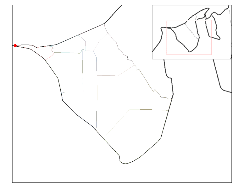
Sungai Tujoh, also abbreviated as Sg. Tujoh, is the westernmost point of Brunei
. It is located in the Belait
district
. The name of the area is derived from two Bruneian Malay
words - Sungai, which means river or stream, and Tujoh or the number seven. Literally, Sungai Tujoh is translated as the Seventh River or Seventh Stream in English.
Although it is sometimes referred to as Kampong Sungai Tujoh, there is no permanent settlement in the area. There is a custom and excise and immigration post at Sungai Tujoh, staffed by 46 immigration officers, as well as a police control post whose function is to monitor the country's border
, to safeguard the security of the country, and to prevent crime.
 Sungai Tujoh is located at the westernmost point in Brunei
, in the Belait
district , and lies across the border from Kampong Rentis in the Malaysian state of Sarawak
. The area is bounded by the border with Malaysia on the west and south side, the South China Sea
to the north and the Sungai Enam area to the east.
It is one of the four land crossing points from Brunei to Sarawak and the only one in the Belait district. The other 3 are Kuala Lurah in the Brunei-Muara district to Limbang
and the Puni
and Labu
Immigration post in the Temburong district to Limbang
and Terusan
respectively.
ceded the basin of the Baram to the White Rajah of Sarawak
, an area of some 10000 square miles (25,899.9 km²), on condition of a perpetual annual payment of 6000 dollars.
The border was delineated in 1958 by the United Kingdom
who then had sovereignty over the colony
of Sarawak and was responsible for the external relations of the protectorate
of Brunei. An immigration post was built in the 1960s to control the movement of goods and people between Miri
and points west in Sarawak with Brunei. It has been continually upgraded since then, with the latest upgrade being made just prior to the opening of the ASEAN Bridge across the Baram River
.
The frequent traveller's card (FTC) was first implemented in 2005 at Sungai Tujoh. This enables residents from both countries to use their Mykad/Smart IC as a legal document for travel between the two countries instead of an international passport
.
There is a scheduled bus service that runs from Kuala Belait
and terminates at the immigration post at Sungai Tujoh. Passengers have to clear customs
and immigration
on foot and take a separate bus to Miri
.
Brunei
Brunei , officially the State of Brunei Darussalam or the Nation of Brunei, the Abode of Peace , is a sovereign state located on the north coast of the island of Borneo, in Southeast Asia...
. It is located in the Belait
Belait
Belait can refer to either:* the Belait District of Brunei Darussalam.* Kuala Belait, the administrative town of the Belait District* the Belait River which flows through the Belait District of Brunei Darussalam....
district
Districts of Brunei
Brunei is divided into four districts :The districts are subdivided into thirty-eight mukim .-See also:*ISO 3166-2:BN*...
. The name of the area is derived from two Bruneian Malay
Malay language
Malay is a major language of the Austronesian family. It is the official language of Malaysia , Indonesia , Brunei and Singapore...
words - Sungai, which means river or stream, and Tujoh or the number seven. Literally, Sungai Tujoh is translated as the Seventh River or Seventh Stream in English.
Although it is sometimes referred to as Kampong Sungai Tujoh, there is no permanent settlement in the area. There is a custom and excise and immigration post at Sungai Tujoh, staffed by 46 immigration officers, as well as a police control post whose function is to monitor the country's border
Brunei-Malaysia border
The border between Brunei and Malaysia consist of a 481.3 km land border and substantial lengths of maritime borders stretching from the coastline of the two countries to the edge of the continental shelf in the South China Sea....
, to safeguard the security of the country, and to prevent crime.
Location

Brunei
Brunei , officially the State of Brunei Darussalam or the Nation of Brunei, the Abode of Peace , is a sovereign state located on the north coast of the island of Borneo, in Southeast Asia...
, in the Belait
Belait
Belait can refer to either:* the Belait District of Brunei Darussalam.* Kuala Belait, the administrative town of the Belait District* the Belait River which flows through the Belait District of Brunei Darussalam....
district , and lies across the border from Kampong Rentis in the Malaysian state of Sarawak
Sarawak
Sarawak is one of two Malaysian states on the island of Borneo. Known as Bumi Kenyalang , Sarawak is situated on the north-west of the island. It is the largest state in Malaysia followed by Sabah, the second largest state located to the North- East.The administrative capital is Kuching, which...
. The area is bounded by the border with Malaysia on the west and south side, the South China Sea
South China Sea
The South China Sea is a marginal sea that is part of the Pacific Ocean, encompassing an area from the Singapore and Malacca Straits to the Strait of Taiwan of around...
to the north and the Sungai Enam area to the east.
It is one of the four land crossing points from Brunei to Sarawak and the only one in the Belait district. The other 3 are Kuala Lurah in the Brunei-Muara district to Limbang
Limbang
Limbang is a border town and the capital of Limbang District in the Limbang Division of northern Sarawak, East Malaysia, on the island of Borneo. The division has an area of 3,978.1 square kilometers, and a population of 42,600...
and the Puni
Puni
Puni is a rural locality in the Franklin District in the North Island of New Zealand. It is predominantly a dairy farming and market gardening area. The main type of crops grown are potatoes, carrots and onions....
and Labu
Labu
Labu is a small town in Negeri Sembilan, Malaysia. The town is located between Seremban and Nilai. The Labu Komuter station, a commuter train station that located at Labu town. Labu also known as 'Datuk Syahbandar Sungai Ujong Motherland' or 'Telapak Datuk Syahbandar Sungai Ujong'. Sadly, there are...
Immigration post in the Temburong district to Limbang
Limbang
Limbang is a border town and the capital of Limbang District in the Limbang Division of northern Sarawak, East Malaysia, on the island of Borneo. The division has an area of 3,978.1 square kilometers, and a population of 42,600...
and Terusan
Lawas
border=1 align=right cellpadding=1 cellspacing=0 width=260 style="margin: 0 0 1em 1em; background: #f9f9f9; border: 1px #aaa solid; border-collapse: collapse; font-size: 95%;"|+Lawas...
respectively.
History
The Sungai Tujoh area has been long claimed by the sultan of Brunei to constitute a part of the sultanate. It was divided in 1882, when the then sultanAbdul Momin
Abdul Momin was the sultan of Brunei from 1852 until his death. He was the son of a nobleman named Pengiran Shahbandar Pengiran Anak Abdul Wahab. Pengiran Anak Abdul Momin succeeded his father in law Omar Ali Saifuddin II as sultan upon the latter's death, having previously served as regent for...
ceded the basin of the Baram to the White Rajah of Sarawak
Sarawak
Sarawak is one of two Malaysian states on the island of Borneo. Known as Bumi Kenyalang , Sarawak is situated on the north-west of the island. It is the largest state in Malaysia followed by Sabah, the second largest state located to the North- East.The administrative capital is Kuching, which...
, an area of some 10000 square miles (25,899.9 km²), on condition of a perpetual annual payment of 6000 dollars.
The border was delineated in 1958 by the United Kingdom
United Kingdom
The United Kingdom of Great Britain and Northern IrelandIn the United Kingdom and Dependencies, other languages have been officially recognised as legitimate autochthonous languages under the European Charter for Regional or Minority Languages...
who then had sovereignty over the colony
Colony
In politics and history, a colony is a territory under the immediate political control of a state. For colonies in antiquity, city-states would often found their own colonies. Some colonies were historically countries, while others were territories without definite statehood from their inception....
of Sarawak and was responsible for the external relations of the protectorate
Protectorate
In history, the term protectorate has two different meanings. In its earliest inception, which has been adopted by modern international law, it is an autonomous territory that is protected diplomatically or militarily against third parties by a stronger state or entity...
of Brunei. An immigration post was built in the 1960s to control the movement of goods and people between Miri
Miri
Miri is a city in northern Sarawak, Malaysia, on the island of Borneo. It is the second largest city in Sarawak, with a population of about 300,000, and the government administrative centre of Miri District in Miri Division....
and points west in Sarawak with Brunei. It has been continually upgraded since then, with the latest upgrade being made just prior to the opening of the ASEAN Bridge across the Baram River
Baram River
The Baram river is a river in Sarawak, East Malaysia on the island of Borneo. The river originates in the central Iran Mountains and flows westwards through tropical rainforest to the South China Sea....
.
The frequent traveller's card (FTC) was first implemented in 2005 at Sungai Tujoh. This enables residents from both countries to use their Mykad/Smart IC as a legal document for travel between the two countries instead of an international passport
Passport
A passport is a document, issued by a national government, which certifies, for the purpose of international travel, the identity and nationality of its holder. The elements of identity are name, date of birth, sex, and place of birth....
.
Transport
The main roads linking the ferry crossing towards the Malaysian border (11 kilometers) and towards Rasau bridge are surfaced.There is a scheduled bus service that runs from Kuala Belait
Kuala Belait
This article refers to the town of Kuala Belait. For the mukim of the same name, please refer to Kuala Belait, Belait. For district, please see Belait district.Kuala Belait |Jawi]]: )is a town located in South-West of Brunei...
and terminates at the immigration post at Sungai Tujoh. Passengers have to clear customs
Customs
Customs is an authority or agency in a country responsible for collecting and safeguarding customs duties and for controlling the flow of goods including animals, transports, personal effects and hazardous items in and out of a country...
and immigration
Immigration
Immigration is the act of foreigners passing or coming into a country for the purpose of permanent residence...
on foot and take a separate bus to Miri
Miri
Miri is a city in northern Sarawak, Malaysia, on the island of Borneo. It is the second largest city in Sarawak, with a population of about 300,000, and the government administrative centre of Miri District in Miri Division....
.

