

Superstition Mountain
Encyclopedia
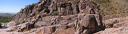
Superstition Mountain is located immediately east of the Phoenix metropolitan area
in Arizona
. It anchors the west end of the Superstition Wilderness. Although its precise origin is debated by geologists, many believe that the mountain was formed from volcanic activity as far back as 25 million years ago. The ash and basalt composed mountain was eroded by the elements to give it the unique form it has today, creating the prominent landmark and popular recreation destination in the region.
The mountain, located near Apache Junction
and Gold Canyon
, Arizona
, is easily accessible from U.S. Route 60 and State Route 88. It is a popular three season (fall, winter, spring) hiking area. Afternoon temperatures from June to September are usually in the range of 100 to 115°F near the mountain. Day hikers often frequent the mountain during cooler months. The Lost Dutchman State Park
is located on the western side of the mountain and includes hiking trails to notable formations such as the Praying Hands and the Flatiron. The Peralta Trail, on the southern side of the mountain, traverses Fremont Saddle and descends into the wilderness to the east of the mountain.
Phoenix Metropolitan Area
The Phoenix metropolitan area, often referred to as The Valley of the Sun, is a metropolitan area, centered on the city of Phoenix, that includes much of the central part of the US state of Arizona...
in Arizona
Arizona
Arizona ; is a state located in the southwestern region of the United States. It is also part of the western United States and the mountain west. The capital and largest city is Phoenix...
. It anchors the west end of the Superstition Wilderness. Although its precise origin is debated by geologists, many believe that the mountain was formed from volcanic activity as far back as 25 million years ago. The ash and basalt composed mountain was eroded by the elements to give it the unique form it has today, creating the prominent landmark and popular recreation destination in the region.
The mountain, located near Apache Junction
Apache Junction, Arizona
Apache Junction is a city in Maricopa and Pinal counties in the U.S. state of Arizona. According to the 2010 Census, the population of the city was 35,840, most of whom lived in Pinal County....
and Gold Canyon
Gold Canyon, Arizona
Gold Canyon is a census-designated place in Pinal County, Arizona, United States. The population was 6,029 at the 2000 census. The community is sometimes incorrectly called Gold Camp....
, Arizona
Arizona
Arizona ; is a state located in the southwestern region of the United States. It is also part of the western United States and the mountain west. The capital and largest city is Phoenix...
, is easily accessible from U.S. Route 60 and State Route 88. It is a popular three season (fall, winter, spring) hiking area. Afternoon temperatures from June to September are usually in the range of 100 to 115°F near the mountain. Day hikers often frequent the mountain during cooler months. The Lost Dutchman State Park
Lost Dutchman State Park
Lost Dutchman State Park is a state park in central Arizona, USA.The park was scheduled to close on June 3, 2010. A man from Katy, Texas donated $8,000 so the park could stay open. This State Park has camping facilities, day use parking and acts as a trailhead for the trails leading into the Tonto...
is located on the western side of the mountain and includes hiking trails to notable formations such as the Praying Hands and the Flatiron. The Peralta Trail, on the southern side of the mountain, traverses Fremont Saddle and descends into the wilderness to the east of the mountain.