
São Miguel do Passa Quatro
Encyclopedia
| São Miguel do Passa Quatro | |
|---|---|
| State | Goiás Goiás Goiás is a state of Brazil, located in the central part of the country. The name Goiás comes from the name of an indigenous community... |
| Coordinates: | 17°03′41"S 48°39′15"W |
| Area: | 537.8 km² |
| Population: | 3,680 (IBGE 2007) |
| Elevation: | 801 m above sea level |
| Postcode (CEP): | 75185-000 |
| IBGE statistical microregion: | 016 Pires do Rio Microregion Pires do Rio Microregion The Pires do Rio Microregion is a statistical region of south-central Goiás state, Brazil. The most important city is Pires do Rio. The area includes 10 cities with a population of 90,327 in an area of 9,449.80 km²... |
| Became a city: | 1989 |
| Distance to Goiânia Goiânia -Climate:The city has a tropical wet and dry climate with an average temperature of . There's a wet season, from October to April, and a dry one, from May to September. Annual rainfall is around 1,520 mm.... : |
112 km |
| Website: | none |
Town
A town is a human settlement larger than a village but smaller than a city. The size a settlement must be in order to be called a "town" varies considerably in different parts of the world, so that, for example, many American "small towns" seem to British people to be no more than villages, while...
and municipality
Municipality
A municipality is essentially an urban administrative division having corporate status and usually powers of self-government. It can also be used to mean the governing body of a municipality. A municipality is a general-purpose administrative subdivision, as opposed to a special-purpose district...
in central Goiás
Goiás
Goiás is a state of Brazil, located in the central part of the country. The name Goiás comes from the name of an indigenous community...
state, Brazil
Brazil
Brazil , officially the Federative Republic of Brazil , is the largest country in South America. It is the world's fifth largest country, both by geographical area and by population with over 192 million people...
.
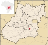
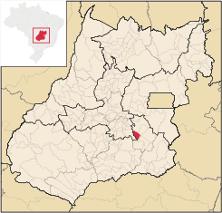
Location
São Miguel is located in the Pires do Rio MicroregionPires do Rio Microregion
The Pires do Rio Microregion is a statistical region of south-central Goiás state, Brazil. The most important city is Pires do Rio. The area includes 10 cities with a population of 90,327 in an area of 9,449.80 km²...
, at a distance of 112 kilometers from the state capital of Goiânia
Goiânia
-Climate:The city has a tropical wet and dry climate with an average temperature of . There's a wet season, from October to April, and a dry one, from May to September. Annual rainfall is around 1,520 mm....
.
Highway connections from Goiânia
Goiânia
-Climate:The city has a tropical wet and dry climate with an average temperature of . There's a wet season, from October to April, and a dry one, from May to September. Annual rainfall is around 1,520 mm....
are made by BR-352 / Bela Vista de Goiás
Bela Vista de Goiás
Bela Vista de Goiás is a small city located in central Goiás state in Brazil.-Location:It is 45 kilometers from the state capital of Goiânia...
/ Cristianópolis
Cristianópolis
This article is about Cristianópolis, Goiás. For Cristianópolis, Mato Grosso see Cristianópolis, Mato GrossoCristianópolis is a small town and municipality in south-eastern Goiás state, Brazil.-Geographical Information:...
/ GO-139. See Sepin for all the distances.
It has boundaries with Bela Vista de Goiás
Bela Vista de Goiás
Bela Vista de Goiás is a small city located in central Goiás state in Brazil.-Location:It is 45 kilometers from the state capital of Goiânia...
, Cristianópolis
Cristianópolis
This article is about Cristianópolis, Goiás. For Cristianópolis, Mato Grosso see Cristianópolis, Mato GrossoCristianópolis is a small town and municipality in south-eastern Goiás state, Brazil.-Geographical Information:...
, Silvânia
Silvânia
Silvânia is a small city and municipality in southcentral Goiás state, Brazil.-Location and highway connections:Silvânia is located 77 kilometers from the state capital of Goiânia, 180 km...
and Vianópolis
Vianópolis
Vianópolis is a small town and municipality in the center of the Brazilian state of Goiás.-Location:Vianópolis is located 90 km. from the state capital, Goiânia. Highway connections are made by BR-457 / GO-010 / GO-330 / passing through the cities of Bonfinópolis, Leopoldo de Bulhões and...
.
Climate
The climate is tropical humid with an average annual temperature of 21 °C. From May to October are the lowest temperatures, between 18 °C and 21 °C, with an average minimum of 9 °C to 13 °C. The hottest months, from September to November, register maximum temperatures of 36 °C to 38 °C. The annual rainfall is around 1,400 millimeters.The elevation varies between 600 and 900 meters above sea level.
Political information
- Mayor: Eleusa França de Melo (January 2005-January 2009)
- City council: 09 members
- Eligible voters: 3,033 (December/2007)
Demographics
- Population density: 6.84 inhab/km² (2007)
- Urban population: 1,870 (2007)
- Rural population: 1,810 (2007)
- Population growth: a gain of about 1,000 people since 1991
The economy
The economy is based on subsistence agriculture, cattle raising, services, public administration, and small transformation industries.- Industrial units: 6 (2007)
- Commercial units: 29 (2007)
- Cattle herd: 32,400 head (5,400 milk cows) (2006)
- Main crops: rice, beans, manioc, guava, oranges, tangerines, corn (1,500 hectares), sorghum, tomatoes, and soybeans (11,000 hectares).
Agricultural data 2006
- Number of farms: 524
- Total area: 30,427 ha.
- Area of permanent crops: 90 ha.
- Area of perennial crops: 5,724 ha.
- Area of natural pasture: 16,939 ha.
- Area of woodland and forests: 6,835 ha.
- Persons dependent on farming: 1,300
- Farms with tractors: 69
- Number of tractors: 105
- Cattle herd: 127,000 head IBGE
Education (2006)
- Schools: 5
- Students: 1,040
- Higher education: none
- Adult literacy rate: 90.0% (2000) (national average was 86.4%)
Health (2007)
- Hospitals: 1
- Hospital beds: 20
- Ambulatory clinics: 3
- Infant mortality rate: 19.70 (2000) (national average was 33.0)
Municipal Human Development Index
Human Development Index
The Human Development Index is a composite statistic used to rank countries by level of "human development" and separate "very high human development", "high human development", "medium human development", and "low human development" countries...
- MHDI: 0.767
- State ranking: 45 (out of 242 municipalities in 2000)
- National ranking: 1,413 (out of 5,507 municipalities in 2000) For the complete list see Frigoletto.com
See also
- List of municipalities in Goiás
- Microregions of Goiás