São Nicolau
Encyclopedia


Cape Verde
The Republic of Cape Verde is an island country, spanning an archipelago of 10 islands located in the central Atlantic Ocean, 570 kilometres off the coast of Western Africa...
. It is located between the islands of Santa Luzia
Santa Luzia, Cape Verde
Santa Luzia is an island of the Barlavento archipelago in Cape Verde located between São Nicolau and São Vicente. The area is 35 km² . The highest point is Monte Grande elevating 395 m...
and Sal
Sal, Cape Verde
Sal is an island in Cape Verde. It belongs to the northern group of islands, called Barlavento. The island is composed by a single administrative division, the Sal municipality. The island is home to Amílcar Cabral International Airport, the main airport of Cape Verde.- Geography :The island is...
. Its population is 12,864, with an area of 388 km². Its economy consists mainly of agriculture as well as fishing and tourism near its beaches. Much of the population is rural. Preguiça Airport
Preguiça Airport
Preguiça is an airport in Cape Verde located in the island of São Nicolau, about 3 km south of the island capital Ribeira Brava. Its IATA code is São Nicolau and the letter E, the last two letters of the ICAO code is São Nicolau...
is located to the south between Vila da Ribeira Brava and Campo.
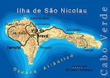
Geography
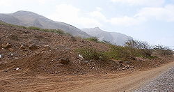
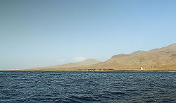
The mountainous island is mostly agricultural but is subject to droughtDrought
A drought is an extended period of months or years when a region notes a deficiency in its water supply. Generally, this occurs when a region receives consistently below average precipitation. It can have a substantial impact on the ecosystem and agriculture of the affected region...
s. The flat areas and hills dominate most of the coastline and the central part. A peninsula covers the eastern part of the island. The highest point on the island is Monte Gordo
Monte Gordo, Cape Verde
Monte Gordo is São Nicolau's tallest mountain located in the westcentral part of the island in Cape Verde. Its height is 1,312 m, some calculates as high as 1,340 m. The mountain and its ranges is entirely of volcanic origin. Since 2005, the municipal boundary of Tarrafal de São Nicolau and Ribeira...
(1,312 m). Other mountains include Monte Bissau
Monte Bissau
For the capital of Guinea-Bissau, see BissauMonte Bissau is a mountain located in the central part of the island of São Nicolau in Cape Verde. The mountaintop is near the centre of the island. The island's summit is located not far and east of Ribeira Brava and west of Juncalinho. The mountain are...
in the central part and Pico do Alberto
Pico do Alberto
Pico do Alberto is a mountain located in the eastern part of São Nicolau island in Cape Verde. The mountain's summit is located south of Juncalinho. The mountain are almost rocky, desert-like and has traces of vegetation. The area around are mountains except for further south where the Atlantic...
to the east.
History
First inhabited in the sixteenth century, it is known for its mountains and for its main town, Ribeira BravaRibeira Brava, Cape Verde
Ribeira Brava is a municipality on the island of São Nicolau of the Barlavento group in Cape Verde.-Parishes:The municipality includes two parishes:*Nossa Senhora da Lapa*Nossa Senhora do Rosário-Settlements:*Agua das Patas*Belém*Cabeçalinho*Cachaço...
, long the seat of the Cape Verde diocese
Diocese
A diocese is the district or see under the supervision of a bishop. It is divided into parishes.An archdiocese is more significant than a diocese. An archdiocese is presided over by an archbishop whose see may have or had importance due to size or historical significance...
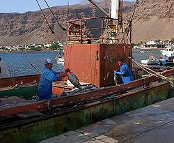
. Its other town is the ferry and the fishing port
Port
A port is a location on a coast or shore containing one or more harbors where ships can dock and transfer people or cargo to or from land....
of Tarrafal
Tarrafal de São Nicolau
Tarrafal de São Nicolau is a recently created municipality on the island of São Nicolau, Cape Verde. It was detached in 2005 from the municipality of São Nicolau...
. A famine affected the entire island in the 1940s which lead to emigration, mainly to São Tomé and Príncipe
São Tomé and Príncipe
São Tomé and Príncipe, officially the Democratic Republic of São Tomé and Príncipe, is a Portuguese-speaking island nation in the Gulf of Guinea, off the western equatorial coast of Central Africa. It consists of two islands: São Tomé and Príncipe, located about apart and about , respectively, off...
.
Administrative division
MunicipallyAdministrative divisions of Cape Verde
The territory of Cape Verde is divided into 22 concelhos , and subdivided into 32 freguesias ....
São Nicolau is divided in two municipalities: Ribeira Brava Municipality and Tarrafal de São Nicolau Municipality. It was originally one municipality: São Nicolau. The split took place in 2005.
Parishes
The municipality formerly included the parishes of São João Baptista and Santo André. Today it administers only one parish. Tarrafal de São NicolauTarrafal de São Nicolau
Tarrafal de São Nicolau is a recently created municipality on the island of São Nicolau, Cape Verde. It was detached in 2005 from the municipality of São Nicolau...
, covering the western part of the island, split from the rest of the island creating its own municipality. It now covers the northern and the eastern portions of the island.
Settlements
- Baixo Roche
- Belém
- Berril
- Cabeçalinho
- Cachaco
- Calejão
- Calhaus
- Campo
- Carriçal
- Carvoeiro
- Castilhano
- Covada
- Estância Bras
- Fajã de Baixo
- Fajã de Cima
- Fontaninhas
- Hortelão
- Jalunga
- JuncalinhoJuncalinhoJuncalinho is village in the northeastern part of the island of São Nicolau. It is part of the municipality of Ribeira Brava...
- Morro BrasMorro BrásMorro Brás is village in the northeastern part of the island island of São Nicolau. It is part of the municipality of Ribeira Brava...
- Praia BrancaPraia BrancaPraia Branca is village and a beach in the northwestern part of the island island of São Nicolau. It is part of the municipality of Tarrafal de São Nicolau...
- PreguiçaPreguiça (São Nicolau), Cape VerdePreguiça is village in the southern part of the island of São Nicolau. It is part of the municipality of Ribeira Brava. It is linked with the road connecting north to Ribeira Brava...
- QueimadaQueimada, Cape VerdeQueimada is village in the northwestcentral part of the island of São Nicolau. It is part of the municipality of Ribeira Brava.-Geography:...
- Ribeira FundaRibeira Funda, Cape VerdeRibeira Funda is village in the northwestcentral part of the island of São Nicolau. It is part of the municipality of Ribeira Brava.-Geography:...
- Ribeira da PontaRibeira da PontaRibeira da Ponta is village in the northwestcentral part of the island of São Nicolau. It is part of the municipality of Ribeira Brava....
- Ribeira BravaRibeira Brava, Cape VerdeRibeira Brava is a municipality on the island of São Nicolau of the Barlavento group in Cape Verde.-Parishes:The municipality includes two parishes:*Nossa Senhora da Lapa*Nossa Senhora do Rosário-Settlements:*Agua das Patas*Belém*Cabeçalinho*Cachaço...
(pop: 4,892) - TarrafalTarrafal de São NicolauTarrafal de São Nicolau is a recently created municipality on the island of São Nicolau, Cape Verde. It was detached in 2005 from the municipality of São Nicolau...
Other
São Nicolau has a few schools or collegiates (colegio), a few lyceums (middle schools), a gymnasium (secondary schools), churches, beaches, ports, a post office and squares (praças).Persons
- Amandio Cabral (b. 1934) - a Capeverdean singer who currently lives in CaliforniaCaliforniaCalifornia is a state located on the West Coast of the United States. It is by far the most populous U.S. state, and the third-largest by land area...
outside Cape Verde - Teofilo ChantreTeófilo ChantreTeófilo Chantre is a Cape Verdean musician.He was born on the island of São Nicolau. At the age of thirteen, Chantre's family left Cape Verde and migrated to Paris, France...
(b. 1964) - a Capeverdean musician - Antonio Gominho - a Capeverdean writer
- Baltasar Lopes da SilvaBaltasar Lopes da SilvaBaltasar Lopes da Silva was a writer, poet and linguist from Cape Verde, who wrote in both Portuguese and Cape Verdean Creole. With Manuel Lopes and Jorge Barbosa, he was the founder of Claridade. In 1947 he published Chiquinho, considered the greatest Cape Verdean novel...
(April 23, 1907 - May 28, 1989 in MindeloMindeloFor the parish in Portugal, see Mindelo, PortugalMindelo , is a port city in the northern part of the island of São Vicente in Cape Verde. Mindelo is also the seat of the parish of Nossa Senhora da Luz, and this island's municipality...
) - José Lopes da Silva (pseudonym: Gabrial Mariano, (1928 - 2003), poet and an essayist

