Takachiho, Miyazaki
Encyclopedia
is a town
located in Nishiusuki District
, Miyazaki Prefecture
, Japan
.
, bordering Kumamoto Prefecture
on its north and northwest sides and Oita Prefecture
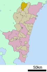
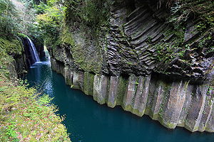
on its north and northeast sides. The Gokase River flows from the west to the southeast part of town. The heart of the town is at its center, around the now defunct Takachiho Station and the business office of Takachiho Kotsu, the town public transportation company. Takachiho Gorge, located in the southern part of town, is fairly famous as a tourist attraction.
Takachiho is about 120 km northwest of the prefectural capital of Miyazaki
and about 80 km southeast of the city of Kumamoto
. Because there are no public transportation facilities, nor are there any national highways
to the capital of Miyazaki, it takes about three hours to get there. And because it takes about half that time to get to the city of Kumamoto, ties between Takachiho and Kumamoto are getting deeper year by year. Ties to Kumamoto are not a recent development, as transportation facilities to the base of Mt. Aso have existed since long ago.

, Takachiho is the land where Ninigi descended from the heavens, sent by Amaterasu
, the sun goddess. It also contains the Ama-no-Iwato shrine which is, according to myth, the location of the cave where Amaterasu hid until Ame-no-Uzume lured her out.
 Takachiho is the heart of the Himuka Myth Road, which extends throughout Miyazaki
.
Towns of Japan
A town is a local administrative unit in Japan. It is a local public body along with prefecture , city , and village...
located in Nishiusuki District
Nishiusuki District, Miyazaki
Nishiusuki is a district located in Miyazaki, Japan.As of 2003, the district has an estimated population of 25,479 and the density of 37.10 persons per km². The total area is 686.77 km².-Towns and villages:*Gokase*Hinokage*Takachiho...
, Miyazaki Prefecture
Miyazaki Prefecture
is a prefecture of Japan located on the island of Kyushu. The capital is the city of Miyazaki.- History :Historically, after the Meiji Restoration, Hyūga Province was renamed Miyazaki Prefecture....
, Japan
Japan
Japan is an island nation in East Asia. Located in the Pacific Ocean, it lies to the east of the Sea of Japan, China, North Korea, South Korea and Russia, stretching from the Sea of Okhotsk in the north to the East China Sea and Taiwan in the south...
.
Geography
Takachiho is located in the northernmost part of Miyazaki PrefectureMiyazaki Prefecture
is a prefecture of Japan located on the island of Kyushu. The capital is the city of Miyazaki.- History :Historically, after the Meiji Restoration, Hyūga Province was renamed Miyazaki Prefecture....
, bordering Kumamoto Prefecture
Kumamoto Prefecture
is a prefecture of Japan located on Kyushu Island. The capital is the city of Kumamoto.- History :Historically the area was called Higo Province; and the province was renamed Kumamoto during the Meiji Restoration. The creation of prefectures was part of the abolition of the feudal system...
on its north and northwest sides and Oita Prefecture
Oita Prefecture
is a prefecture of Japan on Kyūshū Island. The prefectural capital is the city of Ōita.- History :Around the 6th century Kyushu consisted of four regions: Tsukushi-no-kuni 筑紫国, Hi-no-kuni 肥国, and Toyo no kuni...
on its north and northeast sides. The Gokase River flows from the west to the southeast part of town. The heart of the town is at its center, around the now defunct Takachiho Station and the business office of Takachiho Kotsu, the town public transportation company. Takachiho Gorge, located in the southern part of town, is fairly famous as a tourist attraction.
Takachiho is about 120 km northwest of the prefectural capital of Miyazaki
Miyazaki, Miyazaki
is the capital city of Miyazaki Prefecture on the island of Kyūshū in Japan. Located on the coast and perforated by several rivers, Miyazaki City enjoys scenic views of both ocean and nearby, verdant mountains...
and about 80 km southeast of the city of Kumamoto
Kumamoto, Kumamoto
is the capital city of Kumamoto Prefecture on the island of Kyushu, Japan. Greater Kumamoto has a population of 1,460,000, as of the 2000 census...
. Because there are no public transportation facilities, nor are there any national highways
National highways of Japan
Japan has a nationwide system of distinct from the expressways. The Ministry of Land, Infrastructure and Transport and other government agencies administer the national highways. Beginning in 1952, Japan classified these as Class 1 or Class 2. Class 1 highways had one- or two-digit numbers, while...
to the capital of Miyazaki, it takes about three hours to get there. And because it takes about half that time to get to the city of Kumamoto, ties between Takachiho and Kumamoto are getting deeper year by year. Ties to Kumamoto are not a recent development, as transportation facilities to the base of Mt. Aso have existed since long ago.
Neighboring municipalities

- Miyazaki PrefectureMiyazaki Prefectureis a prefecture of Japan located on the island of Kyushu. The capital is the city of Miyazaki.- History :Historically, after the Meiji Restoration, Hyūga Province was renamed Miyazaki Prefecture....
- Nishiusuki DistrictNishiusuki District, MiyazakiNishiusuki is a district located in Miyazaki, Japan.As of 2003, the district has an estimated population of 25,479 and the density of 37.10 persons per km². The total area is 686.77 km².-Towns and villages:*Gokase*Hinokage*Takachiho...
: GokaseGokase, Miyazakiis a town located in Nishiusuki District, Miyazaki, Japan.-Demographics:As of 2003, the town had an estimated population of 4,965 and density of 28.90 persons per km². The total area is 171.77 km². Much of the population work as farmers and fisherman, producing sansai and seema.-External links:*...
, HingokageHinokage, Miyazakiis a town located in Nishiusuki District, Miyazaki, Japan.As of 2003, the town has an estimated population of 5,211 and a density of 18.77 persons per km²... - Higashiusuki DistrictHigashiusuki District, MiyazakiHigashiusuki is a district located in Miyazaki, Japan.As of 2006, the district has an estimated population of 31,269 and the density of 24.18 persons per km²...
: MorotsukaMorotsuka, Miyazakiis a village located in Higashiusuki District, Miyazaki, Japan.As of 2003, the village has an estimated population of 2,202 and the density of 11.74 persons per km². The total area is 187.59 km².To get to Morotsuka, travel north from Hyuga up route 327....
- Nishiusuki District
- Kumamoto PrefectureKumamoto Prefectureis a prefecture of Japan located on Kyushu Island. The capital is the city of Kumamoto.- History :Historically the area was called Higo Province; and the province was renamed Kumamoto during the Meiji Restoration. The creation of prefectures was part of the abolition of the feudal system...
- Aso DistrictAso District, Kumamotois a district located in Kumamoto Prefecture, Japan.As of the Aso and Yamato mergers but with 2003 population data, the district has an estimated population of 40,841 and a density of 58.1 persons per square kilometer...
: TakamoriTakamori, Kumamotois a town located in Aso District, Kumamoto, Japan.As of October 1, 2007 the town has an estimated population of 7,018 and a density of 40.1 persons per km². The total area is 174.90 km².-Geography:... - Kamimashiki DistrictKamimashiki District, Kumamotois a district located in Kumamoto Prefecture, Japan.As of the Yamato merger but with 2003 population statistics, the district had an estimated population of 90,315 and a density of 115.2 persons per square kilometer...
: YamatoYamato, Kumamotois a town located in Kamimashiki District, Kumamoto, Japan.The town was formed on February 11, 2005 from the merger of the municipalities of Yabe and Seiwa with the town of Soyō from Aso District....
- Aso District
- Ōita PrefectureOita Prefectureis a prefecture of Japan on Kyūshū Island. The prefectural capital is the city of Ōita.- History :Around the 6th century Kyushu consisted of four regions: Tsukushi-no-kuni 筑紫国, Hi-no-kuni 肥国, and Toyo no kuni...
- TaketaTaketa, Oitais a city located in Ōita Prefecture, Japan.As of 2003, the city has an estimated population of 16,807 and a density of 83.69 persons per km². The total area is 200.83 km²....
- Bungo-ōnoBungo-ono, Oitais a city located in Ōita Prefecture, Japan.The city was founded on March 31, 2005 as a result of the merger between the municipalities of Asaji, Chitose, Inukai, Kiyokawa, Mie, Ogata and Ōno ....
- Taketa
Mythology
According to Japanese mythologyJapanese mythology
Japanese mythology is a system of beliefs that embraces Shinto and Buddhist traditions as well as agriculturally based folk religion. The Shinto pantheon comprises innumerable kami...
, Takachiho is the land where Ninigi descended from the heavens, sent by Amaterasu
Amaterasu
, or is apart of the Japanese myth cycle and also a major deity of the Shinto religion. She is the goddess of the sun, but also of the universe. the name Amaterasu derived from Amateru meaning "shining in heaven." The meaning of her whole name, Amaterasu-ōmikami, is "the great August kami who...
, the sun goddess. It also contains the Ama-no-Iwato shrine which is, according to myth, the location of the cave where Amaterasu hid until Ame-no-Uzume lured her out.
Junior high schools
- Takachiho Junior High School
- Tabaru Junior High School
- Iwato Junior High School
- Kamino Junior High School
Elementary schools
- Takachiho Elementary School
- Oshikata Elementary School
- Tabaru Elementary School
- Iwato Elementary School
- Kamino Elementary School
Rail
- Takachiho RailwayTakachiho Railwaywas a Japanese railway company. The company in Miyazaki Prefecture had suspended operation of the railway since a typhoon disaster in 2005 and was liquidated in 2009.-Line:...
- Takachiho Line (inactive)
- Ama-no-iwato Station - Takachiho Station
- Takachiho Line (inactive)
Road
- National highwaysNational highways of JapanJapan has a nationwide system of distinct from the expressways. The Ministry of Land, Infrastructure and Transport and other government agencies administer the national highways. Beginning in 1952, Japan classified these as Class 1 or Class 2. Class 1 highways had one- or two-digit numbers, while...
- Japan National Route 218
- Takachiho Roadside StationRoadside StationA is a government-designated rest area found along roads and highways in Japan.In addition to providing places for travelers to rest, they are also intended to promote local tourism and trade...
- Takachiho Roadside Station
- Japan National Route 325
- Japan National Route 218
Scenic and historic places

Miyazaki Prefecture
is a prefecture of Japan located on the island of Kyushu. The capital is the city of Miyazaki.- History :Historically, after the Meiji Restoration, Hyūga Province was renamed Miyazaki Prefecture....
.
- Takachiho Gorge
- Manai Waterfall
- Kunimigaoka
- Ama-no-iwato Jinja Shinto ShrineAmanoiwato-jinjais a Shinto shrine located in Takachiho, Miyazaki prefecture, Japan. It is dedicated to the sun goddess Amaterasu and contains Ama-no-Iwato, the cave where, according to Japanese legend, the goddess hid after battle with her brother, plunging the world into darkness until lured out by the spirit of...
- Shonenji TempleShonenji Temple, Takachihois a temple of the Jōdo Shinshū school of Buddhism. It is located in Takachiho Town, Miyazaki, on Kyūshū, Japan's southernmost main island....
- Takachiho OnsenOnsenAn is a term for hot springs in the Japanese language, though the term is often used to describe the bathing facilities and inns around the hot springs. As a volcanically active country, Japan has thousands of onsen scattered along its length and breadth...
- Takachiho Shrine

