
Tangletown, Minneapolis
Encyclopedia
Tangletown is a neighborhood in the Southwest
Southwest, Minneapolis
The Southwest community consists of the following neighborhoods: Linden Hills, East Harriet, Kingfield, Fulton, Lynnhurst, Tangletown, Armatage, Kenny, and Windom. This portion of Minneapolis contains many parks and trails along Lake Harriet and Minnehaha Creek....
community of Minneapolis. The neighborhood was officially known as Fuller until 1996 when it was changed to the present name, which reflects the winding streets in the neighborhood that do not conform to the regular street grid of South Minneapolis. The neighborhood boundaries are 46th Street to the north, Interstate 35W
Interstate 35W (Minnesota)
Interstate 35W , is an Interstate Highway in the U.S. state of Minnesota, passing through downtown Minneapolis. It is one of two through routes for Interstate 35 through the Twin Cities of Minneapolis and Saint Paul, the other being Interstate 35E through downtown Saint Paul...
to the east, Diamond Lake Road to the south, and Lyndale Avenue South to the west.
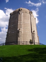
The Washburn Park Water Tower
Washburn Park Water Tower
The Washburn Park Water Tower poses as a landmark of early 20th-Century architectural achievement within the Tangletown neighborhood in south Minneapolis, Minnesota, and has been doing so for nearly 75 years...
is located at the highest point in the neighborhood, while Minnehaha Creek runs through the south side of the neighborhood. Washburn High School
Washburn High School
Minneapolis Washburn High School is a four-year public high school serving grades 9–12 in Minneapolis, Minnesota. By enrollment, Washburn is the fourth-largest high school in the Minneapolis Public School District.Principal Mrs...
is located in this neighborhood.