.gif)
Te Henga (Bethells Beach)
Encyclopedia

North Island
The North Island is one of the two main islands of New Zealand, separated from the much less populous South Island by Cook Strait. The island is in area, making it the world's 14th-largest island...
, New Zealand
New Zealand
New Zealand is an island country in the south-western Pacific Ocean comprising two main landmasses and numerous smaller islands. The country is situated some east of Australia across the Tasman Sea, and roughly south of the Pacific island nations of New Caledonia, Fiji, and Tonga...
. The Māori
Maori language
Māori or te reo Māori , commonly te reo , is the language of the indigenous population of New Zealand, the Māori. It has the status of an official language in New Zealand...
name Te Henga, meaning sand, originally applied to a wide area of the lower Waitakere River valley, but in 1976 the New Zealand Geographic Board changed the name of the beach from Bethells Beach to Te Henga (Bethells Beach).
Location
The beach is approximately 30 kilometres north-west of AucklandAuckland
The Auckland metropolitan area , in the North Island of New Zealand, is the largest and most populous urban area in the country with residents, percent of the country's population. Auckland also has the largest Polynesian population of any city in the world...
City, at the mouth of the Waitakere River where it flows into the Tasman Sea
Tasman Sea
The Tasman Sea is the large body of water between Australia and New Zealand, approximately across. It extends 2,800 km from north to south. It is a south-western segment of the South Pacific Ocean. The sea was named after the Dutch explorer Abel Janszoon Tasman, the first recorded European...
. One of several popular resorts in the area (others include Muriwai
Muriwai
Muriwai, also called Muriwai Beach, is a coastal community located on the west coast of North Island, New Zealand. It is also home to a large colony of gannets.- Location :...
, Piha
Piha
Piha is a northern New Zealand coastal settlement with a population of about 600. It is one of the most popular beaches in the area and a major day-trip destination for Aucklanders throughout the year, although especially so in summer.-Location:...
and Karekare
Karekare, New Zealand
Karekare is a small coastal settlement in northern New Zealand, where the Waitakere Ranges descend into a large black sand surf beach.- Location :It is located 35 kilometres west of Auckland city centre, south of the larger beach of Piha....
), it experiences a population explosion in summer when Aucklanders head to the sea.
History

Pa (Maori)
The word pā can refer to any Māori village or settlement, but in traditional use it referred to hillforts fortified with palisades and defensive terraces and also to fortified villages. They first came into being about 1450. They are located mainly in the North Island north of lake Taupo...
, walkways, canoe landings and sacred places.
The arrival of Europeans in the 19th century led to major changes in the character and shape of Bethells Beach. The most significant of these changes was the clearing of the land for timber and pastoral farming which began in 1854 and continued until the 1920s. In addition, a dam was constructed on the Waitakere River in the 1920s, drastically altering the level of the riverbed and reducing the outflow of water to the sea.
John Bethell negotiated with the Waitakere County Council to sell the land that is now known as Te Henga Park. The Council considered the beach and park area would provide excellent recreation facilities for residents of Auckland. Te Henga was recognised as a place of regional significance.
Activity
- SurfingSurfingSurfing' is a surface water sport in which the surfer rides a surfboard on the crest and face of a wave which is carrying the surfer towards the shore...
is the main pastime. Other pastimes include parasailing and hang gliding, for which the prevailing westerly wind often provides favourable conditions. - FishingFishingFishing is the activity of trying to catch wild fish. Fish are normally caught in the wild. Techniques for catching fish include hand gathering, spearing, netting, angling and trapping....
is also popular, although dangerous in many places and many deaths have taken place from this. - Bush walking is encouraged, with boardwalks in place.
- Sunbathing, swimming, picnics, running etc.
- Skimboarding is also becoming quite popular with young people.
Geology
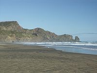
The sand dunes have accumulated in several phases over the last 4,500 years. This accumulation has occurred since sea levels returned to about their present levels following the last glaciation 6,500 years ago. These sands contain quantities of black titanomagnetite derived from the volcanic rocks of Taranaki and carried north by coastal currents. The dunes continually move in a dynamic coastal process.Ecology of the Waitakere River catchment

Waitakere Ranges
The Waitakere Ranges are a chain of hills in the Auckland metropolitan area, generally running approximately 25 km from north to south, 25 km west of central Auckland, New Zealand. The maximum elevation within the ranges is 474 m...
. Located on the west coast of the Auckland
Auckland
The Auckland metropolitan area , in the North Island of New Zealand, is the largest and most populous urban area in the country with residents, percent of the country's population. Auckland also has the largest Polynesian population of any city in the world...
Region approximately 75% of the catchment consists of native vegetation in spite of extensive milling, farming and settlement.
The major features of the catchment are:
- the abundance of native vegetation
- the steep and rugged terrain
- the Te Henga wetland
- the sand dunes
- Lake Wainamu
- The Waitakere Reservoir
The Waitakere River has two main tributaries, the Mokoroa and Waiti streams. The headwaters of the river are in the vast and steep Waitakere Ranges and drain out at the Bethell’s Beach river mouth.
In comparison with other North Island beaches, and to some extent even the west coast beaches of Muriwai and Piha, settlement at Bethells has been minor with most development revolving around horticulture and agriculture.
With the exception of the Waitakere Reservoir the catchments resources have largely escaped development.

Lake Wainamu is a dune lake that formed during the last 6,500 years when the Wainamu Stream Valley was dammed by dunes of sand blown inland. A decline in water quality was noted in 1990s and was thought to be caused by exotic fish accelerating the loss of the submerged plant life. In response the Auckland Regional Council removed over 9,000 exotic fish (particularly perch
Perch
Perch is a common name for fish of the genus Perca, freshwater gamefish belonging to the family Percidae. The perch, of which there are three species in different geographical areas, lend their name to a large order of vertebrates: the Perciformes, from the Greek perke meaning spotted, and the...
, goldfish
Goldfish
The goldfish is a freshwater fish in the family Cyprinidae of order Cypriniformes. It was one of the earliest fish to be domesticated, and is one of the most commonly kept aquarium fish....
and rudd
Rudd
The common rudd Scardinius erythropthalmus is a bentho-pelagic freshwater fish, widely spread in Europe and middle Asia, around the basins of the North, Baltic, Black, Caspian and Aral seas.-Artificially introduced:...
) between 2004 and 2007. In 2009, grass carp
Grass carp
The grass carp is a herbivorous, freshwater fish species of family Cyprinidae, and the only species of the genus Ctenopharyngodon. It is cultivated in China for food, but was introduced in Europe and the United States for aquatic weed control...
were introduced to the lake in an attempt to rid it of introduced egeria
Egeria (genus)
Egeria is a genus of two species of aquatic plants in the family Hydrocharitaceae, native to warm-temperate South America.The genus was formerly included in the related genus Elodea, from which it differs in having the leaves in whorls of four or more, not three, and in having more conspicuous...
.
The lake is also home to native freshwater fish including banded kokopu
Banded kokopu
For a general article about all 3 kokopu.The banded kokopu, Galaxias fasciatus, is a galaxiid of the genus Galaxias, found only in New Zealand, including the Chatham and Stewart/Rakiura islands...
, inanga
Common galaxias
The common galaxias or the inanga , is a species of fish from the galaxiid family that is very widespread in the southern hemisphere. It is a slim narrow fish with a forked tail and as an adult it lives in freshwater rivers and lakes. Common galaxias grows to a length of 40 to 120 mm, but can grow...
, common smelt
New Zealand smelt
The New Zealand smelt, New Zealand common smelt, or New Zealand cucumber fish, Retropinna retropinna, is a smelt of the family Retropinnidae, found only in New Zealand at shallow depths in estuaries and rivers...
, common bully
Common bully
The common bully, Gobiomorphus cotidianus, is a sleeper of the genus Gobiomorphus, found in New Zealand. Their length is up to 15 cm.-References:*...
, grey mullet, longfin
New Zealand longfin eel
The New Zealand Longfin eel is one of three freshwater eels found in New Zealand. The other two species of eel are the Shortfin eel which is also found in south-eastern Australia and the recently arrived Australian Longfin eel .The easiest method for identification of the New Zealand Longfin eel...
and short-finned eel
Short-finned eel
The short-finned eel, Anguilla australis, is one of the 15 species of eel in the family Anguillidae. It is native to the lakes, dams and coastal rivers of south-eastern Australia, New Zealand, and much of the South Pacific, including New Caledonia, Norfolk Island, Lord Howe Island, Tahiti, and...
.
Filming location
The beach has been used as a filming location for several projects, including the music videoMusic video
A music video or song video is a short film integrating a song and imagery, produced for promotional or artistic purposes. Modern music videos are primarily made and used as a marketing device intended to promote the sale of music recordings...
for Shania Twain
Shania Twain
Shania Twain, OC is a Canadian country pop singer-songwriter. Her album The Woman in Me , brought her fame and her 1997 album Come On Over, became the best-selling album of all time by a female musician in any genre, and the best-selling country album of all time. It has sold over 40 million...
's 2003 single "Forever and for Always
Forever and for Always
"Forever and For Always" is a song released by Canadian singer Shania Twain from her 2002 album Up!. The song was written by Mutt Lange and Twain. It was the third single on her album Up!. The single was released in the United States radio on April 7, 2003. The video debuted on Country Music...
", the British/New Zealand TV movie The Man Who Lost His Head
The Man Who Lost His Head
Written by Mark Wallington, The Man Who Lost His Head is a 2-hour, comedy drama starring Martin Clunes, on the theme of cultural repatriation. It was a joint production for TVNZ in New Zealand and ITV in Great Britain...
, and episodes of the U.S. TV series Xena: Warrior Princess
Xena: Warrior Princess
Xena: Warrior Princess is an American–New Zealand supernatural fantasy adventure series that aired in syndication from September 4, 1995 until June 18, 2001....
.
The New Disney Channel Original movie Avalon High
Avalon High
Avalon High is a young adult novel by Meg Cabot, published in 2005. It reached number 3 in The New York Times children's best sellers list in January 2006. A manga sequel called Coronation, Volume one: The Merlin's Prophecy has been released....
was also filmed here during the battle scenes.
External links
- Treasure Island Kids news
- Artmedia - Physical Theatre News
- Waitakere Govt site
- Surf Lifesaving website
- Map
- Zenaland with map
- Photos
- Surfing
- Bethells Beach and Xena film locations - www.loyaltoxena.com
- Bethells Beach Surf Life Saving Patrol - http://www.bethellsbeach.org.nz

