Temperature range
Encyclopedia
Atmospheric temperature range is the numerical difference between the minimum and maximum values of temperature observed in a given location.

 A temperature range may refer to a period of time (e.g., in a given day, month, year, century) or to an average (average of all temperature ranges in a period of time). The variation in temperature that occurs from the highs of the day to the cool of nights is called diurnal temperature variation
.
The size of ground-level atmospheric temperature ranges depends on several factors, such as:
A location which combines an average temperature of 19 degrees Celsius, 60% average humidity and a temperature range of about 10 degrees Celsius around the average temperature (yearly temperature variation) is considered ideal in terms of comfort
for the human species. Most of the places with these characteristics are located in the transition between temperate and tropical climates, approximately around the tropics
, particularly in the Southern hemisphere (the tropic of Capricorn
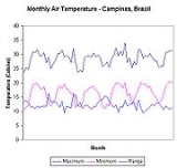
). The figure at left shows an example of monthly temperatures recorded at one of such locations, the city of Campinas
, state of São Paulo
, Brazil
, which lies approximately 60 km north of the Capricorn line (latitude
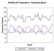
of 22 degrees). Average yearly temperature is 22.4 degrees Celsius, ranging from an average minimum of 12.2 degrees to a maximum of 29.9 degrees. The average temperature range is 11.4 degrees http://www.agritempo.gov.br/agroclima/sumario?uf=SP. Variability along the year is small (standard deviation of 2.31 for the maximum monthly average and 4.11 for the minimum). One can easily see in the graph another typical phenomenon of temperature ranges, which is its increase during winter (lower average air temperature). In Campinas, for example, the daily temperature range in July (the coolest month of the year) may vary between typically 10 and 24 degrees Celsius (range of 14), while in January, it may range between 20 and 30 degrees Celsius (range of 10).
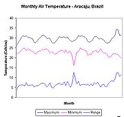
The effect of latitude, tropical climate, constant gentle wind and sea-side locations clearly show smaller average temperature ranges, smaller variations of temperature, and a higher average temperature (second graph, taken for the same period as Campinas, at Aracaju
, capital of the state of Sergipe
, also in Brazil, at a latitude of 10 degrees, nearer to the Equator
). Average maximum yearly temperature is 28.7 degrees Celsius and average minimum is 21.9. The average temperature range is 5.7 degrees only. Temperature variation along the year in Aracaju is very damped (standard deviation of 1.93 for the maximum temperature and 2.72 for the minimum temperature).
, who first reported this phenomenon in 1932 based on observations at different screen heights at six meteorological centers across India. The phenomenon is attributed to the interaction of thermal radiation
effects on atmospheric aerosols and convection
transfer close to the ground.


Diurnal temperature variation
Diurnal temperature variation is a meteorological term that relates to the variation in temperature that occurs from the highs of the day to the cool of nights.-Temperature lag:Temperature lag is an important factor in diurnal temperature variation...
.
The size of ground-level atmospheric temperature ranges depends on several factors, such as:
- The average temperature
- The average humidityHumidityHumidity is a term for the amount of water vapor in the air, and can refer to any one of several measurements of humidity. Formally, humid air is not "moist air" but a mixture of water vapor and other constituents of air, and humidity is defined in terms of the water content of this mixture,...
- The regime of windWindWind is the flow of gases on a large scale. On Earth, wind consists of the bulk movement of air. In outer space, solar wind is the movement of gases or charged particles from the sun through space, while planetary wind is the outgassing of light chemical elements from a planet's atmosphere into space...
s (intensity, duration, variation, temperature, etc.) - The proximity to large bodies of waterWaterWater is a chemical substance with the chemical formula H2O. A water molecule contains one oxygen and two hydrogen atoms connected by covalent bonds. Water is a liquid at ambient conditions, but it often co-exists on Earth with its solid state, ice, and gaseous state . Water also exists in a...
, such as the seaSeaA sea generally refers to a large body of salt water, but the term is used in other contexts as well. Most commonly, it means a large expanse of saline water connected with an ocean, and is commonly used as a synonym for ocean...
A location which combines an average temperature of 19 degrees Celsius, 60% average humidity and a temperature range of about 10 degrees Celsius around the average temperature (yearly temperature variation) is considered ideal in terms of comfort
Comfort
Comfort may refer to:*Comfort , by the rock group Failure*Comfort *Comfort Air, German airline*Comfort food*Comfort noise, artificial background noise used in radio and wireless communications to fill the silent time in a transmission*Comfort object, an object used to provide psychological...
for the human species. Most of the places with these characteristics are located in the transition between temperate and tropical climates, approximately around the tropics
Tropics
The tropics is a region of the Earth surrounding the Equator. It is limited in latitude by the Tropic of Cancer in the northern hemisphere at approximately N and the Tropic of Capricorn in the southern hemisphere at S; these latitudes correspond to the axial tilt of the Earth...
, particularly in the Southern hemisphere (the tropic of Capricorn
Tropic of Capricorn
The Tropic of Capricorn, or Southern tropic, marks the most southerly latitude on the Earth at which the Sun can be directly overhead. This event occurs at the December solstice, when the southern hemisphere is tilted towards the Sun to its maximum extent.Tropic of Capricorn is one of the five...
). The figure at left shows an example of monthly temperatures recorded at one of such locations, the city of Campinas
Campinas
Campinas is a city and municipality located in the coastal interior of the state of São Paulo, Brazil. is the administrative center of the meso-region of the same name, with 3,783,597 inhabitants as of the 2010 Census, consisting of 49 cities....
, state of São Paulo
São Paulo (state)
São Paulo is a state in Brazil. It is the major industrial and economic powerhouse of the Brazilian economy. Named after Saint Paul, São Paulo has the largest population, industrial complex, and economic production in the country. It is the richest state in Brazil...
, Brazil
Brazil
Brazil , officially the Federative Republic of Brazil , is the largest country in South America. It is the world's fifth largest country, both by geographical area and by population with over 192 million people...
, which lies approximately 60 km north of the Capricorn line (latitude
Latitude
In geography, the latitude of a location on the Earth is the angular distance of that location south or north of the Equator. The latitude is an angle, and is usually measured in degrees . The equator has a latitude of 0°, the North pole has a latitude of 90° north , and the South pole has a...
of 22 degrees). Average yearly temperature is 22.4 degrees Celsius, ranging from an average minimum of 12.2 degrees to a maximum of 29.9 degrees. The average temperature range is 11.4 degrees http://www.agritempo.gov.br/agroclima/sumario?uf=SP. Variability along the year is small (standard deviation of 2.31 for the maximum monthly average and 4.11 for the minimum). One can easily see in the graph another typical phenomenon of temperature ranges, which is its increase during winter (lower average air temperature). In Campinas, for example, the daily temperature range in July (the coolest month of the year) may vary between typically 10 and 24 degrees Celsius (range of 14), while in January, it may range between 20 and 30 degrees Celsius (range of 10).
The effect of latitude, tropical climate, constant gentle wind and sea-side locations clearly show smaller average temperature ranges, smaller variations of temperature, and a higher average temperature (second graph, taken for the same period as Campinas, at Aracaju
Aracaju
-Vegetation:Aracaju lies in tropical forest. Rainforests are characterized by high rainfall, with minimum normal annual rainfall between 2,000 mm and 1,700 mm...
, capital of the state of Sergipe
Sergipe
Sergipe , is the smallest state of the Brazilian Federation, located on the northeastern Atlantic coast of the country. It borders on two other states, Bahia to the south and west and Alagoas to the north, and to the east is the Atlantic Ocean...
, also in Brazil, at a latitude of 10 degrees, nearer to the Equator
Equator
An equator is the intersection of a sphere's surface with the plane perpendicular to the sphere's axis of rotation and containing the sphere's center of mass....
). Average maximum yearly temperature is 28.7 degrees Celsius and average minimum is 21.9. The average temperature range is 5.7 degrees only. Temperature variation along the year in Aracaju is very damped (standard deviation of 1.93 for the maximum temperature and 2.72 for the minimum temperature).
Lifted Minimum Temperature
The minimum temperature at night does not occur on the ground but few tens of centimeters above the ground. The lowest temperature layer is called Ramdas layer after L. A. RamdasL. A. Ramdas
L. A. Ramdas was an Indian physicist and meteorologist, known for discovering the atmospheric phenomenon of the Ramdas layer or Lifted Temperature Minimum where the lowest temperature in the atmosphere is not on the ground but a few tens of centimeters above the ground.-Life:Ramdas was trained in...
, who first reported this phenomenon in 1932 based on observations at different screen heights at six meteorological centers across India. The phenomenon is attributed to the interaction of thermal radiation
Thermal radiation
Thermal radiation is electromagnetic radiation generated by the thermal motion of charged particles in matter. All matter with a temperature greater than absolute zero emits thermal radiation....
effects on atmospheric aerosols and convection
Convection
Convection is the movement of molecules within fluids and rheids. It cannot take place in solids, since neither bulk current flows nor significant diffusion can take place in solids....
transfer close to the ground.

