
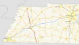
Tennessee State Route 5
Encyclopedia
State Route 5 is a major south–north highway
in West Tennessee
. SR 5 is 120 miles (193.1 km) long and, except for the section north of Union City
, is overlapped with US 45 & 45W.
and is designated as a primary state highway
. In contrast, the northern terminus is quite rural in nature and exists as a two-lane secondary state highway. SR 5 follows Highland Avenue through the City of Jackson, Tennessee
and US 45 Business through Humboldt, Tennessee
. At Union City, Tennessee
, SR 5 becomes a fully signed secondary highway and follows First Street and Main Street through the city. At its junction with US 51, SR 5 continues along Main Street and becomes a primary state highway which overlaps Tennessee State Route 22
. At Lake Drive in Union City, Tennessee State Route 22
turns west toward Samburg, Tennessee
. SR 5 past Lake Drive is signed as a secondary state highway and continues north toward the state line. The signed portion of SR 5 exists entirely within Obion County, Tennessee and is approximately 7.8 miles (12.6 km) in length.
state line, a section of old highway 45 between Bethel Springs
and Selmer
, Tennessee State Route 367 through Trenton
, and a long stretch of old highway between Trenton and Rutherford
.
Originally, SR 5 north of Trenton followed a much different route from the current alignment. From Trenton, SR 5 bent to the northeast, following the old Dresden Road as far as Greenfield
, where it turned north and roughly followed the present-day SR 43
. As evidenced by road maps published by the National Map Company and Rand McNally, sometime between 1927 and 1935, SR 5 was rerouted to follow the former SR 41 north to Kenton
and on to Union City.
has proposed widening SR 5 in Obion County as part of The 2008-2010 Transportation Improvement Program. Right-of-way acquisition will begin in FY 2008 on a section of SR 5 from Troy Station Road to Allie Campbell Road and in FY 2010 for the section between Allie Campbell Road and SR 22
. This will leave a two-lane section of SR 5 from Rutherford, Tennessee
to a point just north of the Obion River
.
Highway
A highway is any public road. In American English, the term is common and almost always designates major roads. In British English, the term designates any road open to the public. Any interconnected set of highways can be variously referred to as a "highway system", a "highway network", or a...
in West Tennessee
West Tennessee
West Tennessee is one of the three Grand Divisions of the State of Tennessee. Of the three, it is the one that is most sharply defined geographically. Its boundaries are the Mississippi River on the west and the Tennessee River on the east...
. SR 5 is 120 miles (193.1 km) long and, except for the section north of Union City
Union City, Tennessee
Union City is a city in Obion County, Tennessee, United States. The population was 10,876 at the 2000 census. It is the county seat of Obion County. The name comes from its location at the union of two railroads, one running roughly east-west and the other roughly north-south...
, is overlapped with US 45 & 45W.
Route description
SR 5 is the hidden designation for US 45 and US 45W for most of the highway's length through the state. SR 5 at its southern terminus is a 4-lane, divided, limited-access expresswayLimited-access road
A limited-access road known by various terms worldwide, including limited-access highway, dual-carriageway and expressway, is a highway or arterial road for high-speed traffic which has many or most characteristics of a controlled-access highway , including limited or no access to adjacent...
and is designated as a primary state highway
State highway
State highway, state road or state route can refer to one of three related concepts, two of them related to a state or provincial government in a country that is divided into states or provinces :#A...
. In contrast, the northern terminus is quite rural in nature and exists as a two-lane secondary state highway. SR 5 follows Highland Avenue through the City of Jackson, Tennessee
Jackson, Tennessee
Jackson is a city in Madison County, Tennessee, United States. The total population was 65,211 at the 2010 census. Jackson is the primary city of the Jackson, Tennessee metropolitan area, which is included in the Jackson-Humboldt, Tennessee Combined Statistical Area...
and US 45 Business through Humboldt, Tennessee
Humboldt, Tennessee
Humboldt is a city in Gibson and Madison counties in the U.S. state of Tennessee. The population was 8,452 at the 2010 census, a decline of 1,015 in 2000. It is the principal city of and is included in the Humboldt, Tennessee Micropolitan Statistical Area, which is included in the Jackson,...
. At Union City, Tennessee
Union City, Tennessee
Union City is a city in Obion County, Tennessee, United States. The population was 10,876 at the 2000 census. It is the county seat of Obion County. The name comes from its location at the union of two railroads, one running roughly east-west and the other roughly north-south...
, SR 5 becomes a fully signed secondary highway and follows First Street and Main Street through the city. At its junction with US 51, SR 5 continues along Main Street and becomes a primary state highway which overlaps Tennessee State Route 22
Tennessee State Route 22
State Route 22 is a south to north highway in Tennessee that is 156.5 miles long, not counting its alternate and bypass sections...
. At Lake Drive in Union City, Tennessee State Route 22
Tennessee State Route 22
State Route 22 is a south to north highway in Tennessee that is 156.5 miles long, not counting its alternate and bypass sections...
turns west toward Samburg, Tennessee
Samburg, Tennessee
Samburg is a town in Obion County, Tennessee, United States. The population was 260 at the 2000 census. It is part of the Union City, TN–KY Micropolitan Statistical Area.-Geography:Samburg is located at ....
. SR 5 past Lake Drive is signed as a secondary state highway and continues north toward the state line. The signed portion of SR 5 exists entirely within Obion County, Tennessee and is approximately 7.8 miles (12.6 km) in length.
Counties traversed
SR 5 traverses the following counties (south to north) shown in the table below.| County | miles | kilometers |
|---|---|---|
| McNairy | 28.17 | 45.34 |
| Chester | 9.74 | 15.68 |
| Madison | 26.29 | 42.31 |
| Gibson | 32.46 | 52.24 |
| Obion | 23.34 | 37.56 |
History
Several old alignments (most are two-lane) of SR 5 exist throughout the state with the most notable examples being near the MississippiMississippi
Mississippi is a U.S. state located in the Southern United States. Jackson is the state capital and largest city. The name of the state derives from the Mississippi River, which flows along its western boundary, whose name comes from the Ojibwe word misi-ziibi...
state line, a section of old highway 45 between Bethel Springs
Bethel Springs, Tennessee
Bethel Springs is a town in McNairy County, Tennessee, United States. The population was 763 at the 2000 census.-Geography:Bethel Springs is located at . Bethel Springs was named after a Presbyterian Church that was founded in the area. The name Bethel cam from Bethlehem, the birth place of Jesus...
and Selmer
Selmer, Tennessee
Selmer is a town in McNairy County, Tennessee, United States, in the southwestern part of the state. The population was 4,541 at the 2000 census. It is the county seat of McNairy County...
, Tennessee State Route 367 through Trenton
Trenton, Tennessee
Trenton is a city in Gibson County, Tennessee, United States. The population was 4,264 at the 2010 census. It is the county seat of Gibson County, and its third largest city.-Geography:Trenton is located at ....
, and a long stretch of old highway between Trenton and Rutherford
Rutherford, Tennessee
Rutherford is a town in Gibson County, Tennessee, United States. At the 2000 census, its population was at 1,272.-Geography:Rutherford is located at ....
.
Originally, SR 5 north of Trenton followed a much different route from the current alignment. From Trenton, SR 5 bent to the northeast, following the old Dresden Road as far as Greenfield
Greenfield, Tennessee
Greenfield is a city in Weakley County, Tennessee, United States. The population was 2,208 at the 2000 census.-Geography:Greenfield is located at ....
, where it turned north and roughly followed the present-day SR 43
Tennessee State Route 43
State Route 43 is a south to north highway in Tennessee that is 56.79 miles long. It begins in Madison County and ends in Obion County. State Route 43 is little-known by the general public by this designation as it is overlain by U.S. Route 45E for most of its length; the "43" designation is seen...
. As evidenced by road maps published by the National Map Company and Rand McNally, sometime between 1927 and 1935, SR 5 was rerouted to follow the former SR 41 north to Kenton
Kenton, Tennessee
Kenton is a town in Gibson and Obion counties in the U.S. state of Tennessee. The population was 1,281 at the 2010 census, a decline of 25 from the 2000 census...
and on to Union City.
Future
TDOTTennessee Department of Transportation
The Tennessee Department of Transportation is a multimodal agency with statewide responsibilities in aviation, public transit, waterways and railroads...
has proposed widening SR 5 in Obion County as part of The 2008-2010 Transportation Improvement Program. Right-of-way acquisition will begin in FY 2008 on a section of SR 5 from Troy Station Road to Allie Campbell Road and in FY 2010 for the section between Allie Campbell Road and SR 22
Tennessee State Route 22
State Route 22 is a south to north highway in Tennessee that is 156.5 miles long, not counting its alternate and bypass sections...
. This will leave a two-lane section of SR 5 from Rutherford, Tennessee
Rutherford, Tennessee
Rutherford is a town in Gibson County, Tennessee, United States. At the 2000 census, its population was at 1,272.-Geography:Rutherford is located at ....
to a point just north of the Obion River
Obion River
The Obion River system is the primary surface water drainage system of northwestern Tennessee.The Obion has four major forks, the North Fork, Middle Fork, South Fork and Rutherford Fork . The confluences of these forks are only a few miles above the mouth of the Obion's discharge into the...
.
Major intersections
| County | Location | Mile | Intersects | Notes |
|---|---|---|---|---|
Unsigned  begins at Mississippi begins at MississippiMississippi Mississippi is a U.S. state located in the Southern United States. Jackson is the state capital and largest city. The name of the state derives from the Mississippi River, which flows along its western boundary, whose name comes from the Ojibwe word misi-ziibi... State Line.  overlap for 60.6 miles (97.5 km). overlap for 60.6 miles (97.5 km). |
||||
| McNairy | Eastview Eastview, Tennessee Eastview is a town in McNairy County, Tennessee, United States. The population was 618 at the 2000 census.-Geography:Eastview is located at .... |
5.7 | To Shiloh National Park & Pickwick Landing State Park Pickwick Landing State Park Pickwick Landing State Park is a state park in Hardin County, Tennessee, located in the Southeastern United States. The park is situated around the Pickwick Lake impoundment of the Tennessee River, and is named for Pickwick Landing, a 19th-century riverboat stop.-External links:* — official... |
|
| Selmer Selmer, Tennessee Selmer is a town in McNairy County, Tennessee, United States, in the southwestern part of the state. The population was 4,541 at the 2000 census. It is the county seat of McNairy County... |
10.3 | |||
| 11.6 | Begin US 64 (westbound), US 45 (northbound), SR 5 overlap around Selmer. US 64 BUS continues west through downtown Selmer | |||
| 16.9 | End US 64 overlap. US 64 BUS continues east through downtown Selmer | |||
| 29.0 | ||||
| Chester | Henderson Henderson, Tennessee Henderson is an incorporated city in Chester County, Tennessee, United States. The population was 5,670 at the 2000 census. It is the county seat of Chester County... |
|||
| 34.5 | ||||
| 34.8 | ||||
| 37.2 | ||||
| Madison | Jackson Jackson, Tennessee Jackson is a city in Madison County, Tennessee, United States. The total population was 65,211 at the 2010 census. Jackson is the primary city of the Jackson, Tennessee metropolitan area, which is included in the Jackson-Humboldt, Tennessee Combined Statistical Area... |
|||
| 47.5 | ||||
Unsigned  changes to secondary designation. changes to secondary designation. |
||||
| 51.4 |  |
US 45 Bypass (northbound) and US 70 (westbound) overlap. US 45 and SR 5 continue northbound through downtown Jackson. | ||
| 54.4 |  |
|||
| 55.7 | ||||
| 60.6 | |
US 45 and SR 5 continue northbound. Unsigned SR 186 overlaps US 45 / SR 5. | ||
| Unsigned changes to primary designation. |
||||
| Three Way Three Way, Tennessee Three Way is a city in Madison County, Tennessee, United States. The population was 1,375 at the 2000 census. It is included in the Jackson, Tennessee Metropolitan Statistical Area... |
62.4 | End US 45. SR 5 overlaps US 45W and continues northbound. Unsigned SR 186 overlaps US 45E and continues northbound. Unsigned SR 43 begins and follows US 45E. | ||
 overlap begins. overlap begins. |
||||
| Gibson | Humboldt Humboldt, Tennessee Humboldt is a city in Gibson and Madison counties in the U.S. state of Tennessee. The population was 8,452 at the 2010 census, a decline of 1,015 in 2000. It is the principal city of and is included in the Humboldt, Tennessee Micropolitan Statistical Area, which is included in the Jackson,... |
|||
| 66.5 | |
Unsigned SR 366 (northbound) begins overlap with US 45W. | ||
| Unsigned changes to secondary designation. Business overlap begins. |
||||
| 68.0 | |
SR 5 and US 45W overlaps with US 70A BUS and US 79 BUS through downtown Humboldt. | ||
| 68.4 | |
SR 5, US 45W, US 70A BUS, US 79 BUS overlap ends. SR 5 and US 45W continue north along Central Avenue. | ||
| 68.7 | ||||
| 69.6 | End US 45W BUS. US 45W and SR 5 continue northbound. | |||
| Unsigned changes to primary designation. overlap resumes for 43.3 miles (69.7 km). |
||||
| 73.3 | ||||
| Trenton Trenton, Tennessee Trenton is a city in Gibson County, Tennessee, United States. The population was 4,264 at the 2010 census. It is the county seat of Gibson County, and its third largest city.-Geography:Trenton is located at .... |
||||
| 76.9 | US 45W and SR 5 turns right and continues north. SR 457 turns left to Dyersburg. SR 367 continues north through downtown Trenton. | |||
| 78.9 | Begin unsigned SR 54 overlap with US 45W and SR 5. | |||
| 79.3 | ||||
| 79.9 | Begin Unsigned SR 77 overlap. | |||
| 81.3 | End Unsigned SR 54 overlap with US 45W and SR 5. | |||
| 82.4 | ||||
| Dyer Dyer, Tennessee Dyer is a city in Gibson County, Tennessee, United States. The population was 2,406 at the 2000 census. Dyer was originally known as Peck's Switch, a name given by railroad workers in the early days of rail.-Tornado outbreak of April 2, 2006:... |
87.9 | End Unsigned SR 77 overlap. | ||
| Rutherford Rutherford, Tennessee Rutherford is a town in Gibson County, Tennessee, United States. At the 2000 census, its population was at 1,272.-Geography:Rutherford is located at .... |
91.7 | |||
| Expressway Ends. Unsigned continues north as a two-lane road. |
||||
| Obion | Kenton Kenton, Tennessee Kenton is a town in Gibson and Obion counties in the U.S. state of Tennessee. The population was 1,281 at the 2010 census, a decline of 25 from the 2000 census... |
97.3 | SR 89 overlaps with US 45W and SR 5 for a short distance in Kenton. | |
| 107.9 | Begin Unsigned SR 21 Overlap. | |||
| 109.0 | ||||
| Union City Union City, Tennessee Union City is a city in Obion County, Tennessee, United States. The population was 10,876 at the 2000 census. It is the county seat of Obion County. The name comes from its location at the union of two railroads, one running roughly east-west and the other roughly north-south... |
||||
| 112.9 | US 45W departs SR 5 overlapped with unsigned SR 184. SR 5 continues north overlapped with unsigned SR 21. | |||
| changes to secondary designation and continues north as a signed highway through downtown Union City. overlap ends. |
||||
| 113.7 | End SR 21 Overlap. | |||
| 114.3 | Begin SR 22 overlap. SR 5 changes to primary designation. | |||
| 115.5 | End SR 22 Overlap. SR 5 changes to secondary designation and continues north. To Reelfoot Lake State Park Reelfoot Lake State Park Reelfoot Lake State Park is a state park in the northwest corner of Tennessee in the United States. It encompasses Reelfoot Lake and is situated in Lake and Obion counties. A major hunting and fishing preserve, it comprises , of which are water, and harbors almost every kind of shorebird, as well... |
|||
| ends at Kentucky Kentucky The Commonwealth of Kentucky is a state located in the East Central United States of America. As classified by the United States Census Bureau, Kentucky is a Southern state, more specifically in the East South Central region. Kentucky is one of four U.S. states constituted as a commonwealth... State Line. Highway continues as  |
||||