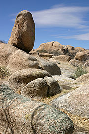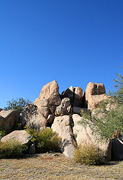
Texas Canyon
Encyclopedia


Cochise County, Arizona
-2010:Whereas according to the 2010 U.S. Census Bureau:*78.5% White*4.2% Black*1.2% Native American*1.9% Asian*0.3% Native Hawaiian or Pacific Islander*4.0% Two or more races*9.6% Other races*32.4% Hispanic or Latino -2000:...
about 20 miles east of Benson
Benson, Arizona
-Transportation:Benson Airport is located 3 miles north west of the city.Benson is served by Interstate 10 to the north, which travels directly to downtown Tucson....
on Interstate 10
Interstate 10 in Arizona
In the U.S. state of Arizona, Interstate 10, the major east–west Interstate Highway in the southern United States, runs east from California, enters Arizona and continues through Phoenix and Tucson and exits at the border with New Mexico.-Route description:...
and lies between the Little Dragoon Mountains on the north and the Dragoon Mountains
Dragoon Mountains
Dragoon Mountains are a range of mountains located in Cochise County, Arizona. The range is about 25 mi long, running on an axis extending south-south east through Willcox.- Geography :...
to the south. Known for the giant granite
Granite
Granite is a common and widely occurring type of intrusive, felsic, igneous rock. Granite usually has a medium- to coarse-grained texture. Occasionally some individual crystals are larger than the groundmass, in which case the texture is known as porphyritic. A granitic rock with a porphyritic...
boulders, the canyon
Canyon
A canyon or gorge is a deep ravine between cliffs often carved from the landscape by a river. Rivers have a natural tendency to reach a baseline elevation, which is the same elevation as the body of water it will eventually drain into. This forms a canyon. Most canyons were formed by a process of...
frequently attracts rockhounds and photographers.
History
The stagecoachStagecoach
A stagecoach is a type of covered wagon for passengers and goods, strongly sprung and drawn by four horses, usually four-in-hand. Widely used before the introduction of railway transport, it made regular trips between stages or stations, which were places of rest provided for stagecoach travelers...
route of the Butterfield Overland Mail
Butterfield Overland Mail
The Butterfield Overland Mail Trail was a stagecoach route in the United States, operating from 1857 to 1861. It was a conduit for the U.S. mail from two eastern termini, Memphis, Tennessee and St. Louis, Missouri, meeting Fort Smith, Arkansas, and continuing through Indian Territory, New Mexico,...
passed through Texas Canyon from 1858 until the outbreak of the Civil War
American Civil War
The American Civil War was a civil war fought in the United States of America. In response to the election of Abraham Lincoln as President of the United States, 11 southern slave states declared their secession from the United States and formed the Confederate States of America ; the other 25...
in 1862 when the stage
Stagecoach
A stagecoach is a type of covered wagon for passengers and goods, strongly sprung and drawn by four horses, usually four-in-hand. Widely used before the introduction of railway transport, it made regular trips between stages or stations, which were places of rest provided for stagecoach travelers...
line suspended operations. The canyon is historically within the range of the Chiricahua Apache, and Cochise
Cochise
Cochise was a chief of the Chokonen band of the Chiricahua Apache and the leader of an uprising that began in 1861. Cochise County, Arizona is named after him.-Biography:...
made his last stronghold near here in the Dragoon Mountains during the mid-1870s.
In the mid to late 1880s David A. Adams arrived from Coleman County, Texas, soon to be followed by other family members. The family became the namesake of Texas Canyon, as there were "a bunch of damned Texans up there." Descendants still live and raise cattle on the old family ranch.
The Amerind Foundation
Amerind Foundation
The Amerind Foundation is museum and research facility dedicated to the preservation and interpretation of Native American cultures and their histories...
, a privately funded archaeological and ethnographic research facility, library, museum and art gallery founded by William Shirley Fulton
William Shirley Fulton
William Shirley Fulton, , an archeologist and founder of the Amerind Foundation was born in Waterbury, Connecticut. He received a Bachelor of Arts degree from Yale University in 1903.-Biography:...
in the 1930s lies about a mile south of I-10
Interstate 10 in Arizona
In the U.S. state of Arizona, Interstate 10, the major east–west Interstate Highway in the southern United States, runs east from California, enters Arizona and continues through Phoenix and Tucson and exits at the border with New Mexico.-Route description:...
in Texas Canyon at Exit 318.
The Triangle T Guest Ranch also lies about a mile south of I-10. This historic guest ranch has overnight accommodations (RV sites and casitas), a saloon and restaurant. The ranch has been the filming location for many commercials, movies and TV shows.

