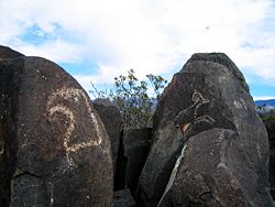
Three Rivers Petroglyph Site
Encyclopedia

Petroglyph
Petroglyphs are pictogram and logogram images created by removing part of a rock surface by incising, picking, carving, and abrading. Outside North America, scholars often use terms such as "carving", "engraving", or other descriptions of the technique to refer to such images...
s at the Three Rivers Petroglyph Site at Three Rivers, New Mexico
Three Rivers, New Mexico
Three Rivers is an unincorporated community in Otero County, United States. Its elevation is 4,570 feet .-Notable people:*Virginia Klinekole, first female president of the Mescalero Apache, 1959*Sara Misquez, president of the Mescalero Apache...
, located midway between Tularosa
Tularosa, New Mexico
Tularosa is a village in Otero County, New Mexico, United States. It shares its name with the Tularosa Basin, in which the town is located. To the east, Tularosa is flanked by the western edge of the Sacramento Mountains. The population was 2,864 at the 2000 census...
and Carrizozo
Carrizozo, New Mexico
Carrizozo is a town in and the county seat of Lincoln County, New Mexico, United States. The population was 1,036 at the 2000 census.-Geography:Carrizozo is located at ....
in Otero County
Otero County, New Mexico
-2010:Whereas according to the 2010 U.S. Census Bureau:*72.7% White*3.5% Black*6.7% Native American*1.2% Asian*0.2% Native Hawaiian or Pacific Islander*4.2% Two or more races*11.2% Other races*34.5% Hispanic or Latino -2000:...
on highway 54. Many of the petroglyphs can be easily viewed from a trail open to the public which winds through the rocks for about one mile. The petroglyphs are thought to be the product of the Jornada Mogollon people between about 1000 and 1400 AD. The site is protected and maintained by the Bureau of Land Management
Bureau of Land Management
The Bureau of Land Management is an agency within the United States Department of the Interior which administers America's public lands, totaling approximately , or one-eighth of the landmass of the country. The BLM also manages of subsurface mineral estate underlying federal, state and private...
.
The petroglyphs at Three Rivers were recorded during a 6 year project by the Archaeological Society of New Mexico's Rock Art Recording Field Schools. Photographs and records are on file at the Bureau of Land Management
Bureau of Land Management
The Bureau of Land Management is an agency within the United States Department of the Interior which administers America's public lands, totaling approximately , or one-eighth of the landmass of the country. The BLM also manages of subsurface mineral estate underlying federal, state and private...
's District Office in Las Cruces
Las Cruces, New Mexico
Las Cruces, also known as "The City of the Crosses", is the county seat of Doña Ana County, New Mexico, United States. The population was 97,618 in 2010 according to the 2010 Census, making it the second largest city in the state....
.

