

Tibbitt to Contwoyto Winter Road
Encyclopedia
Tibbitt to Contwoyto Winter Road is an annual ice road
first built in 1982 to service mines and exploration activities in the Northwest Territories
and Nunavut
in Northern Canada
. Between 400 kilometre long, the road is said to be the world's longest heavy haul ice road and operates for eight to ten weeks starting in the last week of January. Most of the road (85%–87%) is built over frozen lakes, 495 km (307.6 mi), with the remaining 73 km (45.4 mi) built on over 64 land portage
s between lakes. This ice road was the location first season of Ice Road Truckers
.
 The winter road
is constructed by Nuna Logistics and RTL-Robinson every January and takes about six weeks to complete. The first vehicle along each season is a Swedish-made Hägglund
army-type reconnaissance
vehicle designed to float if it falls through the ice; it tows an ice-thickness-detecting sonar
. This is followed by road building equipment including "specialized low ground pressure equipment". The road, built extra wide to avoid blockages during blizzard
s and to allow opposing truck
s to pass, is kept clear of snow
, which acts as insulation
, throughout the season as removal allows the ice to freeze faster and thicker. The road is 50 m (164 ft) wide on the ice, but narrower on land portages ranging between 12 metre wide. Once initially built, the road is checked by drilling holes into the ice. If the ice needs to be thickened, water trucks are called in to add water to that specific area. The road is only operational during February and March, an average of 67 days per year. The ice has been proven by engineers to support light vehicle loads at 70 cm (27.6 in) and increasing to full highway truck loads as the ice thickens. A thickness of 107 cm (42.1 in) is required for a super B
tanker carrying up to 50000 l (105,668.9 US pt) and may weigh up to 42 t (41.3 LT).
On some lakes, traffic may be re-routed to new lanes to avoid damaged or rough sections of ice, and additional "express lanes" allow returning, empty trucks to travel at higher speeds.
The highest allowable speed for fully loaded trucks on the ice is 25 km/h (15.5 mph) with some areas reduced to only 10 km/h (6.2 mph). Empty trucks have a maximum speed limit of 60 km/h (37.3 mph) on the ice. Speed limits are strictly enforced by security personnel with radar
used to clock speeds just as national and provincial police forces do.
There are three road camps servicing drivers hauling loads along the road, they are at: Dome Lake Maintenance Camp, Lockhart Lake and Lac de Gras
. Dome Lake is for maintenance crew and emergency use for drivers, Lockhart Lake provides drivers with food, shower, and a place to do laundry
. Lac de Gras is for road crews, emergency use and for driver facilities for drivers travelling north of Ekati.
Truck driver
s are not allowed to travel the winter road alone, therefore, up to four trucks are dispatched from Yellowknife every 20 minutes. Heavy and wide loads are dispatched from Yellowknife between 12:00 am and 6:00 am to avoid daily commuter traffic.
The main product shipped is diesel fuel and other materiel includes "cement
, tire
s, prill
(ammonium nitrate) for explosives
manufacture, and construction materials."
in 1960–1961 by John Denison. This road began at Discovery Mine
which was already connected to Yellowknife by ice road up the Yellowknife River
and swung east to Gordon Lake, heading north up Drybones, Lockhart and Mackay Lakes where the Tundra Mine was located. This route was used until 1968 when the mine closed.
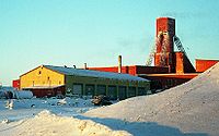
The road was reopened in 1979 as part of an equipment haul to the new Lupin Mine
at Contwoyto Lake
, now Nunavut but then the NWT, pioneered by Robinson's Trucking and Hugh Arden. It followed the old Discovery Mine to Gordon Lake route. An experimental operation, Lupin decided not to continue using the road at this time and relied instead on Hercules C-130 aircraft to haul in machinery during construction of the mine.
In 1983, the ice road to Lupin Mine reopened as an economic alternative to yearly freight haul using aircraft. The section between Tibbitt Lake (at the end of the Ingraham Trail
) and Gordon Lake was built at this time. Another gold mine, the Salmita Mine
(operated between 1983 and 1987) also benefited from this ice road.
Until 1998, the road was licensed and operated by Echo Bay Mines, owners of the Lupin Mine, after which it became a joint venture between Echo Bay Mines, BHP Billiton
, and Diavik Diamond Mines.
Since 1999, the road has been licensed and operated by the Tibbitt to Contwoyto Winter Road Joint Venture, today a partnership between BHP Billiton, Diavik Diamond Mines (Rio Tinto Group
) and De Beers Canada
. The road is engineered by EBA Engineering, and, since 1998, Nuna Logistics, a 51% Inuit
owned joint venture between the Nunasi Corporation, Kitikmeot Corporation and Nuna Management Group, has been responsible for the annual construction, maintenance, dispatching, and camp catering for the primary road, with RTL Enterprises taking care of the secondary road. Security on the road, provided by SecureCheck until 2009, is now provided by Det’on Cho Scarlet Security. Det’on Cho is a Yellowknives
Dene
company with headquarters in N'Dilo
and Scarlet Security, based in Yellowknife, is an Alarand affiliate.
The year 2007 saw record usage of the ice road with 10,922 loads north, totalling 330002 t (324,789.1 LT). That record number doesn't include the 818 back hauls south, totalling 15000 t (14,763.1 LT). The road was open for 73 days from January 27 to April 9, only closed for a total of 91.5 hours (70 hours due to storms and 21.5 hours due to minor incidents). There were over 700 drivers registered during 2007 with nine accidents and one minor injury (a bruised shoulder). During the record 2007 season, there were 99 verbal, 5 written warnings and 5 speeding violations. Nine five-day suspensions and seven season suspensions were issued.
In 2007 the road was featured on The History Channel series called Ice Road Truckers
. The mining company that owned the road where the first season was filmed felt that the show portrayed the road in a negative fashion, and decided not to participate in future seasons of the show. A new rule for the Tibbitt to Contwoyto Winter Roads was enacted for the 2008 season prohibiting commercial, media, video or rolling film cameras either inside or attached to the outside of vehicle. The show's producers said that they had located an alternate ice road and that there would be a second season of the show; the road featured in season 2 was the Tuktoyaktuk Winter Road
.
From there, it winds its way north the following destinations:
The road ends in Jericho Diamond Mine, at the north end of Contwoyto Lake, Nunavut.
Ice road
Ice roads are frozen, human-made structures on the surface of bays, rivers, lakes, or seas in the far north. They link dry land, frozen waterways, portages and winter roads, and are usually remade each winter. Ice roads allow temporary transport to areas with no permanent road access...
first built in 1982 to service mines and exploration activities in the Northwest Territories
Northwest Territories
The Northwest Territories is a federal territory of Canada.Located in northern Canada, the territory borders Canada's two other territories, Yukon to the west and Nunavut to the east, and three provinces: British Columbia to the southwest, and Alberta and Saskatchewan to the south...
and Nunavut
Nunavut
Nunavut is the largest and newest federal territory of Canada; it was separated officially from the Northwest Territories on April 1, 1999, via the Nunavut Act and the Nunavut Land Claims Agreement Act, though the actual boundaries had been established in 1993...
in Northern Canada
Northern Canada
Northern Canada, colloquially the North, is the vast northernmost region of Canada variously defined by geography and politics. Politically, the term refers to the three territories of Canada: Yukon, Northwest Territories, and Nunavut...
. Between 400 kilometre long, the road is said to be the world's longest heavy haul ice road and operates for eight to ten weeks starting in the last week of January. Most of the road (85%–87%) is built over frozen lakes, 495 km (307.6 mi), with the remaining 73 km (45.4 mi) built on over 64 land portage
Portage
Portage or portaging refers to the practice of carrying watercraft or cargo over land to avoid river obstacles, or between two bodies of water. A place where this carrying occurs is also called a portage; a person doing the carrying is called a porter.The English word portage is derived from the...
s between lakes. This ice road was the location first season of Ice Road Truckers
Ice Road Truckers
Ice Road Truckers is a documentary-style reality television series that premiered on History on June 17, 2007.-History:In 2000, History aired a 46-minute episode titled "Ice Road Truckers" as part of the Suicide Missions series...
.
Construction and operation
Winter road
Winter roads are temporary highways carved out of snow and ice. They facilitate transportation to and from communities without permanent roads, and are commonly seen in isolated regions in Canada's north....
is constructed by Nuna Logistics and RTL-Robinson every January and takes about six weeks to complete. The first vehicle along each season is a Swedish-made Hägglund
Bandvagn 206
Bandvagn 206 is a tracked articulated, all-terrain carrier developed by Hägglunds for the Swedish Army. It consists of two units, with all four tracks powered...
army-type reconnaissance
Reconnaissance
Reconnaissance is the military term for exploring beyond the area occupied by friendly forces to gain information about enemy forces or features of the environment....
vehicle designed to float if it falls through the ice; it tows an ice-thickness-detecting sonar
Sonar
Sonar is a technique that uses sound propagation to navigate, communicate with or detect other vessels...
. This is followed by road building equipment including "specialized low ground pressure equipment". The road, built extra wide to avoid blockages during blizzard
Blizzard
A blizzard is a severe snowstorm characterized by strong winds. By definition, the difference between blizzard and a snowstorm is the strength of the wind. To be a blizzard, a snow storm must have winds in excess of with blowing or drifting snow which reduces visibility to 400 meters or ¼ mile or...
s and to allow opposing truck
Truck
A truck or lorry is a motor vehicle designed to transport cargo. Trucks vary greatly in size, power, and configuration, with the smallest being mechanically similar to an automobile...
s to pass, is kept clear of snow
Snow
Snow is a form of precipitation within the Earth's atmosphere in the form of crystalline water ice, consisting of a multitude of snowflakes that fall from clouds. Since snow is composed of small ice particles, it is a granular material. It has an open and therefore soft structure, unless packed by...
, which acts as insulation
Thermal insulation
Thermal insulation is the reduction of the effects of the various processes of heat transfer between objects in thermal contact or in range of radiative influence. Heat transfer is the transfer of thermal energy between objects of differing temperature...
, throughout the season as removal allows the ice to freeze faster and thicker. The road is 50 m (164 ft) wide on the ice, but narrower on land portages ranging between 12 metre wide. Once initially built, the road is checked by drilling holes into the ice. If the ice needs to be thickened, water trucks are called in to add water to that specific area. The road is only operational during February and March, an average of 67 days per year. The ice has been proven by engineers to support light vehicle loads at 70 cm (27.6 in) and increasing to full highway truck loads as the ice thickens. A thickness of 107 cm (42.1 in) is required for a super B
B-Train
In the simplest terms a B-Train consists of two trailers linked together by a fifth wheel, and are up to 26 m long. The fifth wheel coupling is located at the rear of the lead, or first trailer and is mounted on a "tail" section commonly located immediately above the lead trailer axles...
tanker carrying up to 50000 l (105,668.9 US pt) and may weigh up to 42 t (41.3 LT).
On some lakes, traffic may be re-routed to new lanes to avoid damaged or rough sections of ice, and additional "express lanes" allow returning, empty trucks to travel at higher speeds.
The highest allowable speed for fully loaded trucks on the ice is 25 km/h (15.5 mph) with some areas reduced to only 10 km/h (6.2 mph). Empty trucks have a maximum speed limit of 60 km/h (37.3 mph) on the ice. Speed limits are strictly enforced by security personnel with radar
Doppler radar
A Doppler radar is a specialized radar that makes use of the Doppler effect to produce velocity data about objects at a distance. It does this by beaming a microwave signal towards a desired target and listening for its reflection, then analyzing how the frequency of the returned signal has been...
used to clock speeds just as national and provincial police forces do.
There are three road camps servicing drivers hauling loads along the road, they are at: Dome Lake Maintenance Camp, Lockhart Lake and Lac de Gras
Lac de Gras
Lac de Gras is a lake approximately 300 km north of Yellowknife, Northwest Territories, Canada. Lac de Gras was the centre of the Canadian diamond rush of the 1990s. There are two working diamond mines in the area, Ekati Diamond Mine, and Diavik Diamond Mine.It was called Ekati by aboriginal...
. Dome Lake is for maintenance crew and emergency use for drivers, Lockhart Lake provides drivers with food, shower, and a place to do laundry
Laundry
Laundry is a noun that refers to the act of washing clothing and linens, the place where that washing is done, and/or that which needs to be, is being, or has been laundered...
. Lac de Gras is for road crews, emergency use and for driver facilities for drivers travelling north of Ekati.
Truck driver
Truck driver
A truck driver , is a person who earns a living as the driver of a truck, usually a semi truck, box truck, or dump truck.Truck drivers provide an essential service to...
s are not allowed to travel the winter road alone, therefore, up to four trucks are dispatched from Yellowknife every 20 minutes. Heavy and wide loads are dispatched from Yellowknife between 12:00 am and 6:00 am to avoid daily commuter traffic.
The main product shipped is diesel fuel and other materiel includes "cement
Cement
In the most general sense of the word, a cement is a binder, a substance that sets and hardens independently, and can bind other materials together. The word "cement" traces to the Romans, who used the term opus caementicium to describe masonry resembling modern concrete that was made from crushed...
, tire
Tire
A tire or tyre is a ring-shaped covering that fits around a wheel rim to protect it and enable better vehicle performance by providing a flexible cushion that absorbs shock while keeping the wheel in close contact with the ground...
s, prill
Prill
A prill is a small aggregate of a material, most often a dry sphere, formed from a melted liquid. The material to be prilled must be a solid at room temperature and a low viscosity liquid when melted. Prills are formed by allowing drops of the melted prill substance to congeal or freeze in mid-air...
(ammonium nitrate) for explosives
Explosive material
An explosive material, also called an explosive, is a reactive substance that contains a great amount of potential energy that can produce an explosion if released suddenly, usually accompanied by the production of light, heat, sound, and pressure...
manufacture, and construction materials."
History
The Tibbitt to Contwoyto Ice Road follows part of the original road that was cleared to the Tundra MineTundra Mine
The Tundra Mine was a gold producer in the Northwest Territories, Canada between 1964 and 1968, producing 104,476 troy ounces of gold from 187,714 tons of ore. A detailed history is provided in the link below...
in 1960–1961 by John Denison. This road began at Discovery Mine
Discovery Mine
The Discovery Mine was a gold mine 81 kilometers northeast of Yellowknife, Northwest Territories that operated between 1950 and 1969. Gold was discovered here by Alfred Giauque in 1944....
which was already connected to Yellowknife by ice road up the Yellowknife River
Yellowknife River
The Yellowknife River is a river in the Northwest Territories, Canada. It flows south and empties into Yellowknife Bay, part of Great Slave Lake, at the city of Yellowknife. The name of the river derives from the Yellowknife tribe, a First Nations people that formerly lived in the area.The city of...
and swung east to Gordon Lake, heading north up Drybones, Lockhart and Mackay Lakes where the Tundra Mine was located. This route was used until 1968 when the mine closed.
| Year | Road Opened | Road Closed | Freight Carried Tonne Tonne The tonne, known as the metric ton in the US , often put pleonastically as "metric tonne" to avoid confusion with ton, is a metric system unit of mass equal to 1000 kilograms. The tonne is not an International System of Units unit, but is accepted for use with the SI... s | Super B B-Train In the simplest terms a B-Train consists of two trailers linked together by a fifth wheel, and are up to 26 m long. The fifth wheel coupling is located at the rear of the lead, or first trailer and is mounted on a "tail" section commonly located immediately above the lead trailer axles... Capacity Reached | Number of Truck Loads North |
|---|---|---|---|---|---|
| 2000 | January 29 | April 3 | 111,090 | n/a | 3,703 |
| 2001 | February 1 | April 13 | 245,586 | ~March 3 | 7,981 |
| 2002 | January 26 | April 16 | 256,915 | February 22 | 7,735 |
| 2003 | February 1 | April 2 | 198,818 | February 21 | 5,243 |
| 2004 | January 28 | March 31 | 179,144 | February 23 | 5,091 |
| 2005 | January 26 | April 5 | 252,533 | February 20 | 7,607 |
| 2006 | February 4 | March 26 | 177,674 | not reached | 6,841 |
| 2007 | January 27 | April 9 | 330,002 | February 26 | 10,922 |
| 2008 | January 29 | April 7 | 245,585 | February 15 | 7,387 |
| 2009 | February 1 | March 25 | 173,195 | February 15 | 5,377 |
| 2010 | February 4 | March 24 | 121,000 | TBA | 3,506 |
| 2011 | January 28 | March 31 | 241,000 | TBA | 6,831 |
The road was reopened in 1979 as part of an equipment haul to the new Lupin Mine
Lupin Mine
Lupin Mine was a gold mine in Nunavut Territory, Canada. It opened in 1982 and was originally owned and operated by Echo Bay Mines Limited, who in 2003 became a fully owned subsidiary of Kinross Gold Corporation....
at Contwoyto Lake
Contwoyto Lake
Contwoyto Lake is a lake in the Kitikmeot Region of the Canadian territory of Nunavut, located near the border with the Northwest Territories. With a total area of , it is the territories' tenth largest lake.Lupin Mine is located near Contwoyto Lake...
, now Nunavut but then the NWT, pioneered by Robinson's Trucking and Hugh Arden. It followed the old Discovery Mine to Gordon Lake route. An experimental operation, Lupin decided not to continue using the road at this time and relied instead on Hercules C-130 aircraft to haul in machinery during construction of the mine.
In 1983, the ice road to Lupin Mine reopened as an economic alternative to yearly freight haul using aircraft. The section between Tibbitt Lake (at the end of the Ingraham Trail
Ingraham Trail
Highway 4, known more commonly as the Ingraham Trail, extends from Yellowknife, Northwest Territories to Tibbitt Lake, approximately east of Yellowknife...
) and Gordon Lake was built at this time. Another gold mine, the Salmita Mine
Salmita Mine
The Salmita Mine was a gold producer in the Northwest Territories, Canada during 1983 to 1987. The deposit was first discovered in 1945 and underground exploration was carried out in 1951-1952. It was reactivated for exploration by Giant Yellowknife Mines Limited in 1975 and entered production in...
(operated between 1983 and 1987) also benefited from this ice road.
Until 1998, the road was licensed and operated by Echo Bay Mines, owners of the Lupin Mine, after which it became a joint venture between Echo Bay Mines, BHP Billiton
BHP Billiton
BHP Billiton is a global mining, oil and gas company headquartered in Melbourne, Australia and with a major management office in London, United Kingdom...
, and Diavik Diamond Mines.
Since 1999, the road has been licensed and operated by the Tibbitt to Contwoyto Winter Road Joint Venture, today a partnership between BHP Billiton, Diavik Diamond Mines (Rio Tinto Group
Rio Tinto Group
The Rio Tinto Group is a diversified, British-Australian, multinational mining and resources group with headquarters in London and Melbourne. The company was founded in 1873, when a multinational consortium of investors purchased a mine complex on the Rio Tinto river, in Huelva, Spain from the...
) and De Beers Canada
De Beers
De Beers is a family of companies that dominate the diamond, diamond mining, diamond trading and industrial diamond manufacturing sectors. De Beers is active in every category of industrial diamond mining: open-pit, underground, large-scale alluvial, coastal and deep sea...
. The road is engineered by EBA Engineering, and, since 1998, Nuna Logistics, a 51% Inuit
Inuit
The Inuit are a group of culturally similar indigenous peoples inhabiting the Arctic regions of Canada , Denmark , Russia and the United States . Inuit means “the people” in the Inuktitut language...
owned joint venture between the Nunasi Corporation, Kitikmeot Corporation and Nuna Management Group, has been responsible for the annual construction, maintenance, dispatching, and camp catering for the primary road, with RTL Enterprises taking care of the secondary road. Security on the road, provided by SecureCheck until 2009, is now provided by Det’on Cho Scarlet Security. Det’on Cho is a Yellowknives
Yellowknives
The Yellowknives, Yellow Knives, Copper Indians, Red Knives or T'atsaot'ine are Aboriginal peoples of Canada, one of the five main groups of the Dene indigenous people that live in the Northwest Territories of Canada...
Dene
Dene
The Dene are an aboriginal group of First Nations who live in the northern boreal and Arctic regions of Canada. The Dené speak Northern Athabaskan languages. Dene is the common Athabaskan word for "people" . The term "Dene" has two usages...
company with headquarters in N'Dilo
N'Dilo
N'Dilo is a First Nations community in the North Slave Region of the Northwest Territories, Canada. The small Dene community is located on the edge of Yellowknife on the tip of Latham Island.It has a population of approximately 200 people...
and Scarlet Security, based in Yellowknife, is an Alarand affiliate.
The year 2007 saw record usage of the ice road with 10,922 loads north, totalling 330002 t (324,789.1 LT). That record number doesn't include the 818 back hauls south, totalling 15000 t (14,763.1 LT). The road was open for 73 days from January 27 to April 9, only closed for a total of 91.5 hours (70 hours due to storms and 21.5 hours due to minor incidents). There were over 700 drivers registered during 2007 with nine accidents and one minor injury (a bruised shoulder). During the record 2007 season, there were 99 verbal, 5 written warnings and 5 speeding violations. Nine five-day suspensions and seven season suspensions were issued.
In 2007 the road was featured on The History Channel series called Ice Road Truckers
Ice Road Truckers
Ice Road Truckers is a documentary-style reality television series that premiered on History on June 17, 2007.-History:In 2000, History aired a 46-minute episode titled "Ice Road Truckers" as part of the Suicide Missions series...
. The mining company that owned the road where the first season was filmed felt that the show portrayed the road in a negative fashion, and decided not to participate in future seasons of the show. A new rule for the Tibbitt to Contwoyto Winter Roads was enacted for the 2008 season prohibiting commercial, media, video or rolling film cameras either inside or attached to the outside of vehicle. The show's producers said that they had located an alternate ice road and that there would be a second season of the show; the road featured in season 2 was the Tuktoyaktuk Winter Road
Tuktoyaktuk Winter Road
The Tuktoyaktuk Winter Road is an ice road on frozen Mackenzie River delta channels and the frozen Arctic Ocean between the Northwest Territories communities of Inuvik and Tuktoyaktuk, in Canada. It exists in the winter only...
.
Primary route
The ice road begins about 65 km (40.4 mi) east of Yellowknife at the end of Highway 4, more commonly known as the Ingraham Trail.From there, it winds its way north the following destinations:
| Distance | Location | Territory | Notes | |
|---|---|---|---|---|
| 0 | 0 | Tibbitt Lake Tibbitt Lake Tibbitt Lake is a lake in the Canadian Northwest Territories.Located 69.2 kilometres east of Yellowknife, the lake marks the northern terminus of the Ingraham Trail... |
NT Northwest Territories The Northwest Territories is a federal territory of Canada.Located in northern Canada, the territory borders Canada's two other territories, Yukon to the west and Nunavut to the east, and three provinces: British Columbia to the southwest, and Alberta and Saskatchewan to the south... |
Start of road |
| 7 | 4.3 | Meadows Station | NT Northwest Territories The Northwest Territories is a federal territory of Canada.Located in northern Canada, the territory borders Canada's two other territories, Yukon to the west and Nunavut to the east, and three provinces: British Columbia to the southwest, and Alberta and Saskatchewan to the south... |
Security checkpoint |
| 35 | 21.7 | Dome Lake | NT Northwest Territories The Northwest Territories is a federal territory of Canada.Located in northern Canada, the territory borders Canada's two other territories, Yukon to the west and Nunavut to the east, and three provinces: British Columbia to the southwest, and Alberta and Saskatchewan to the south... |
Maintenance camp |
| 170 | 105.6 | Lockhart Lake | NT Northwest Territories The Northwest Territories is a federal territory of Canada.Located in northern Canada, the territory borders Canada's two other territories, Yukon to the west and Nunavut to the east, and three provinces: British Columbia to the southwest, and Alberta and Saskatchewan to the south... |
Rest stop |
| 264 | 164 | Snap Lake Diamond Mine Snap Lake Diamond Mine The Snap Lake Diamond Mine is located about northeast of Yellowknife, Northwest Territories, and, according to De Beers, was their first mine outside Africa and Canada's first completely underground diamond mine.... |
NT Northwest Territories The Northwest Territories is a federal territory of Canada.Located in northern Canada, the territory borders Canada's two other territories, Yukon to the west and Nunavut to the east, and three provinces: British Columbia to the southwest, and Alberta and Saskatchewan to the south... |
Owned by De Beers Canada De Beers De Beers is a family of companies that dominate the diamond, diamond mining, diamond trading and industrial diamond manufacturing sectors. De Beers is active in every category of industrial diamond mining: open-pit, underground, large-scale alluvial, coastal and deep sea... and located southeast of the road |
| Gahcho Kue Diamond Mine Project Gahcho Kue Diamond Mine Project The Gahcho Kué Diamond Project is located on the Canadian tundra in the Northwest Territories. It is situated at Kennady Lake , in the Akaitcho Treaty 8 Territory AK claim block, which is southeast of the Snap Lake Diamond Mine Project and approximately east northeast of Yellowknife... |
NT Northwest Territories The Northwest Territories is a federal territory of Canada.Located in northern Canada, the territory borders Canada's two other territories, Yukon to the west and Nunavut to the east, and three provinces: British Columbia to the southwest, and Alberta and Saskatchewan to the south... |
Owned by a joint-venture between Mountain Province Diamonds Mountain Province Diamonds Mountain Province Diamonds Inc. is major partner with De Beers in the Gahcho Kue Diamond Mine Project in the Northwest Territories. Gahcho Kué is the largest diamond mine under development in the Western hemisphere with an estimated reserve of 50.5 million carats... and De Beers Canada, located southeast of the road |
||
| 350 | 217.5 | Lac de Gras Lac de Gras Lac de Gras is a lake approximately 300 km north of Yellowknife, Northwest Territories, Canada. Lac de Gras was the centre of the Canadian diamond rush of the 1990s. There are two working diamond mines in the area, Ekati Diamond Mine, and Diavik Diamond Mine.It was called Ekati by aboriginal... |
NT Northwest Territories The Northwest Territories is a federal territory of Canada.Located in northern Canada, the territory borders Canada's two other territories, Yukon to the west and Nunavut to the east, and three provinces: British Columbia to the southwest, and Alberta and Saskatchewan to the south... |
Rest stop (for Lupin/Jericho traffic only) |
| 373 | 231.8 | Diavik Diamond Mine Diavik Diamond Mine The Diavik Diamond Mine is a diamond mine in the North Slave Region of the Northwest Territories, Canada, about north of Yellowknife.It has become an important part of the regional economy, employing 700, grossing C$100 million in sales, and producing 8 million carats of diamonds annually... |
NT Northwest Territories The Northwest Territories is a federal territory of Canada.Located in northern Canada, the territory borders Canada's two other territories, Yukon to the west and Nunavut to the east, and three provinces: British Columbia to the southwest, and Alberta and Saskatchewan to the south... |
Owned by a joint venture between the Harry Winston Diamond Corporation and Diavik Diamond Mines, a subsidiary of Rio Tinto Group Rio Tinto Group The Rio Tinto Group is a diversified, British-Australian, multinational mining and resources group with headquarters in London and Melbourne. The company was founded in 1873, when a multinational consortium of investors purchased a mine complex on the Rio Tinto river, in Huelva, Spain from the... |
| 378 | 234.9 | Misery | NT Northwest Territories The Northwest Territories is a federal territory of Canada.Located in northern Canada, the territory borders Canada's two other territories, Yukon to the west and Nunavut to the east, and three provinces: British Columbia to the southwest, and Alberta and Saskatchewan to the south... |
Satellite mining camp of the Ekati Diamond Mine Ekati Diamond Mine The EKATI Diamond Mine is Canada's first surface and underground diamond mine. It is located north-east of Yellowknife, Northwest Territories, and about south of the Arctic circle, near Lac de Gras. EKATI is a joint venture between BHP Billiton Canada Inc... |
| 405 | 251.7 | Ekati Diamond Mine Ekati Diamond Mine The EKATI Diamond Mine is Canada's first surface and underground diamond mine. It is located north-east of Yellowknife, Northwest Territories, and about south of the Arctic circle, near Lac de Gras. EKATI is a joint venture between BHP Billiton Canada Inc... |
NT Northwest Territories The Northwest Territories is a federal territory of Canada.Located in northern Canada, the territory borders Canada's two other territories, Yukon to the west and Nunavut to the east, and three provinces: British Columbia to the southwest, and Alberta and Saskatchewan to the south... |
Owned by BHP Billiton BHP Billiton BHP Billiton is a global mining, oil and gas company headquartered in Melbourne, Australia and with a major management office in London, United Kingdom... , northwest of the road |
| Pellatt Lake | NT Northwest Territories The Northwest Territories is a federal territory of Canada.Located in northern Canada, the territory borders Canada's two other territories, Yukon to the west and Nunavut to the east, and three provinces: British Columbia to the southwest, and Alberta and Saskatchewan to the south... /NU Nunavut Nunavut is the largest and newest federal territory of Canada; it was separated officially from the Northwest Territories on April 1, 1999, via the Nunavut Act and the Nunavut Land Claims Agreement Act, though the actual boundaries had been established in 1993... |
Crossing the NT/NU border | ||
| 568 | 352.9 | Lupin Gold Mine Lupin Mine Lupin Mine was a gold mine in Nunavut Territory, Canada. It opened in 1982 and was originally owned and operated by Echo Bay Mines Limited, who in 2003 became a fully owned subsidiary of Kinross Gold Corporation.... |
NU Nunavut Nunavut is the largest and newest federal territory of Canada; it was separated officially from the Northwest Territories on April 1, 1999, via the Nunavut Act and the Nunavut Land Claims Agreement Act, though the actual boundaries had been established in 1993... |
Closed 2006, owned by Echo Bay Mines Limited |
| 600 | 372.8 | Jericho Diamond Mine Jericho Diamond Mine The Jericho Diamond Mine is a dormant diamond mine located in Canada's Nunavut territory. Jericho is Nunavut’s first and only diamond mine. It is located northeast of Yellowknife, Northwest Territories and is accessible by air all year and by winter road from Yellowknife... |
NU Nunavut Nunavut is the largest and newest federal territory of Canada; it was separated officially from the Northwest Territories on April 1, 1999, via the Nunavut Act and the Nunavut Land Claims Agreement Act, though the actual boundaries had been established in 1993... |
Closed 2008, owned by Tahera Diamond Corporation |
The road ends in Jericho Diamond Mine, at the north end of Contwoyto Lake, Nunavut.
Secondary route
The secondary route begins about 20 km (12.4 mi) east of Yellowknife at Prosperous Lake. The road heads north across the lake just to the west of Cassidy Point and through Quyta Lake where some of the earliest gold samples were found in 1933. From there the road continues north to Johnston Lake and then northeast to Giauque Lake, with a road heading west to the old Discovery Mine, now the Yellowknife Gold Project operated by Tyhee Development. From Giauque the road travels east across Thistlethwaite Lake and northeast through Smokey Lake before joining the main route just north of Gordon Lake.External links
- NWT Road Reports at the Government of Northwest Territories]