

Toro Peak
Encyclopedia
Toro Peak is a mountain in Southern California in the Santa Rosa Mountains
.
South of Palm Springs, west of the Salton Sea
, east of Temecula, California.
It is the highest mountain in the Santa Rosa Mountains, part of the mountain is administered
under the San Bernardino National Forest
the other portions including the 8,716 ft summit and
the United States Geological Survey
marker on the summit registers year 1939 and portions of the mountain are
controlled and gated under the Santa Rosa Indian Reservation Another portion of the mountain is
under the Santa Rosa and San Jacinto Mountains National Monument
.
This mountain is easily visible from California State Route 74
looking south (also known as the Pines to Palms Highway)
the turn off is easily seen marked by a large sign along the south side of Route 74 for the Santa Rosa Mountains
.
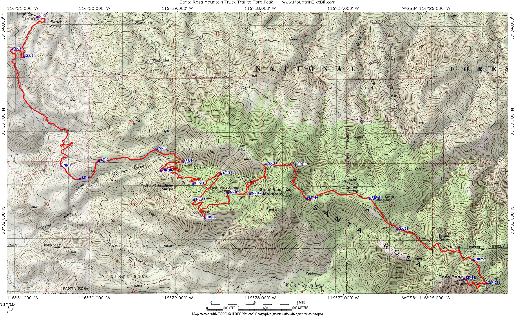
From this point onward the road heads southeast toward the mountain this is a rough dirt road that climbs
steadily for approximately 13 miles.
A 4x4 or off-road vehicle is highly recommended for this road as it becomes steep, rocky and rough in various spots as it
continues to climb the mountain, the road starting elevation is around 4,700' and climbs to a locked gate around 8,200 ft
At that point you will have to hike or bike the last 500 feet up the summit, its a short walk up a rough maintenance road
that passes by former MCI
's (now owned by Verizon Communications
) primary power generator that
provides electricity to the summit as there are no electrical load lines that climb the mountain.
From Toro Peak's summit at an elevation of 8,716' (2,657 M) a commanding view of eastern southern California,
including views of the entire Santa Rosa Mountains to Palm Springs
, neighboring mountains such as Mount San Jacinto
,
Mount San Gorgonio, southwest looking to Palomar Mountain
and Hot Springs Mountain
all just to name a few.
To the east / southeast the Salton Sea and Imperial Valley are visible, on very clear days one may be able to
see Charleston Peak to the northeast in Nevada.
Toro Peak and the Santa Rosa Mountains are what as known as a sky island
. The trees on this mountain have a nearly uniform
mixed variety of forest from as soon as the first trees appear on the lower slopes fading chaparral out to the summit, the mix of
Incense Cedar, White Fir
, Jeffrey Pine
, Ponderosa Pine
, Sugar Pine
and the highest slopes
retain surviving ice age remnants of Limber Pine
, all other species of these trees ignore elevation separations
of vegetation or known as life zones, as seen on many other mountains, this is typical of the mountains closest to the pacific in California, where the trees "appear" For example white firs demonstrated in this picture at right, mixed trees at the lower timberline]] White Fir
and Incense Cedar are seen growing on the lowest extent of the mountain beside dryer weather tolerant trees such as Jeffrey Pine
and Ponderosa Pine
of the mountains cleary separated on other mountains by life zones designated by elevation.
. Nighttime / daytime seasonal lows in the winter and seasonal summer highs are taken from long valley ranger station, on neighboring Mount San Jacinto which is within 30 miles of toro's peak's summit and within 300 ft of Toro Peak's summit so the quantitative differences are minimal but this is the closest to being accurate as possible, in the image at right are some statistics taken from Long Valley ranger station / Mount San Jacinto (image to right)
This mountain is just one of the many scattered sky islands in the southwest, another unique mountain in southern California
, high elevations to clear the smog emitted by Los Angeles
and the Inland Empire
, remoteness, limited human activity and remote campsites in various parts of the mountain make this a mountain of unique properties.
Album of Toro Peak pictures, August 2009
Santa Rosa Mountains
Santa Rosa Mountains may refer to the following mountains in the United States of America:*Santa Rosa Mountains *Santa Rosa Mountains Other similar names include*The Santa Rosa Range in northern Nevada...
.
South of Palm Springs, west of the Salton Sea
Salton Sea
The Salton Sea is a shallow, saline, endorheic rift lake located directly on the San Andreas Fault, predominantly in California's Imperial Valley. The lake occupies the lowest elevations of the Salton Sink in the Colorado Desert of Imperial and Riverside counties in Southern California. Like Death...
, east of Temecula, California.
It is the highest mountain in the Santa Rosa Mountains, part of the mountain is administered
under the San Bernardino National Forest
San Bernardino National Forest
San Bernardino National Forest is a federally-managed forest covering more than 800,000 acres . There are two main divisions which are the San Bernardino Mountains on the easternmost of the Transverse Range, and the San Jacinto and Santa Rosa Mountains on the northernmost of the Peninsular...
the other portions including the 8,716 ft summit and
the United States Geological Survey
United States Geological Survey
The United States Geological Survey is a scientific agency of the United States government. The scientists of the USGS study the landscape of the United States, its natural resources, and the natural hazards that threaten it. The organization has four major science disciplines, concerning biology,...
marker on the summit registers year 1939 and portions of the mountain are
controlled and gated under the Santa Rosa Indian Reservation Another portion of the mountain is
under the Santa Rosa and San Jacinto Mountains National Monument
Santa Rosa and San Jacinto Mountains National Monument
The Santa Rosa and San Jacinto Mountains National Monument is a National Monument in Southern California. It includes portions of the Santa Rosa and San Jacinto Mountain ranges, the northernmost ones of the Peninsular Ranges system...
.
This mountain is easily visible from California State Route 74
California State Route 74
State Route 74 , a part of the Pines to Palms Scenic Byway, is a mostly scenic highway in the U.S. state of California. It runs from Palm Desert in Riverside County westward to San Juan Capistrano in Orange County.-Route description:...
looking south (also known as the Pines to Palms Highway)
the turn off is easily seen marked by a large sign along the south side of Route 74 for the Santa Rosa Mountains
Santa Rosa Mountains
Santa Rosa Mountains may refer to the following mountains in the United States of America:*Santa Rosa Mountains *Santa Rosa Mountains Other similar names include*The Santa Rosa Range in northern Nevada...
.
From this point onward the road heads southeast toward the mountain this is a rough dirt road that climbs
steadily for approximately 13 miles.
A 4x4 or off-road vehicle is highly recommended for this road as it becomes steep, rocky and rough in various spots as it
continues to climb the mountain, the road starting elevation is around 4,700' and climbs to a locked gate around 8,200 ft
At that point you will have to hike or bike the last 500 feet up the summit, its a short walk up a rough maintenance road
that passes by former MCI
MCI Inc.
MCI, Inc. is an American telecommunications subsidiary of Verizon Communications that is headquartered in Ashburn, Virginia...
's (now owned by Verizon Communications
Verizon Communications
Verizon Communications Inc. is a global broadband and telecommunications company and a component of the Dow Jones Industrial Average...
) primary power generator that
provides electricity to the summit as there are no electrical load lines that climb the mountain.
From Toro Peak's summit at an elevation of 8,716' (2,657 M) a commanding view of eastern southern California,
including views of the entire Santa Rosa Mountains to Palm Springs
Palm Springs
Palm Springs is a desert city in CaliforniaPalm Springs may also refer to:* Palm Springs, Florida* Palm Springs, Hong Kong, a residential development in Yuen Long, Hong Kong* Coachella Valley, also known as the Palm Springs area...
, neighboring mountains such as Mount San Jacinto
Mount San Jacinto
Mount San Jacinto may refer to* A dormant volcano located on Kruzof Island in Alaska, U.S., currently named Mount Edgecumbe* San Jacinto Peak, the highest peak in Riverside County, California...
,
Mount San Gorgonio, southwest looking to Palomar Mountain
Palomar Mountain
Palomar Mountain is a mountain in the Peninsular Ranges in northern San Diego County. It is famous as the location of the Palomar Observatory and Hale Telescope, and known for the Palomar Mountain State Park.-History:...
and Hot Springs Mountain
Hot Springs Mountain
Hot Springs Mountain is a located in the Peninsular Ranges in California. The mountain rises to an elevation of and is the highest point in San Diego County. Some snow falls on the mountain peak during winter....
all just to name a few.
To the east / southeast the Salton Sea and Imperial Valley are visible, on very clear days one may be able to
see Charleston Peak to the northeast in Nevada.
Vegetation
Toro Peak and the Santa Rosa Mountains are what as known as a sky island
Sky island
Sky islands are mountains that are isolated by surrounding lowlands of a dramatically different environment, a situation which, in combination with the altitudinal zonation of ecosystems, has significant implications for natural habitats. Endemism, vertical migration, and relict populations are...
. The trees on this mountain have a nearly uniform
mixed variety of forest from as soon as the first trees appear on the lower slopes fading chaparral out to the summit, the mix of
Incense Cedar, White Fir
White Fir
White Fir is a fir native to the mountains of western North America, occurring at altitudes of 900-3,400 m. It is a medium to large evergreen coniferous tree growing to 25–60 m tall and with a trunk diameter of up to 2 m . It is popular as an ornamental landscaping tree and as a Christmas Tree...
, Jeffrey Pine
Jeffrey Pine
The Jeffrey Pine, Pinus jeffreyi, named in honor of its botanist documenter John Jeffrey, is a North American pine related to Ponderosa Pine.-Distribution and habitat:...
, Ponderosa Pine
Ponderosa Pine
Pinus ponderosa, commonly known as the Ponderosa Pine, Bull Pine, Blackjack Pine, or Western Yellow Pine, is a widespread and variable pine native to western North America. It was first described by David Douglas in 1826, from eastern Washington near present-day Spokane...
, Sugar Pine
Sugar Pine
Pinus lambertiana, commonly known as the sugar pine or sugar cone pine, is the tallest and most massive pine, with the longest cones of any conifer...
and the highest slopes
retain surviving ice age remnants of Limber Pine
Limber Pine
The Limber Pine, Pinus flexilis, is a species of pine tree-the family Pinaceae that occurs in the mountains of the Western United States, Mexico, and Canada. It is also called Southwestern White Pine and Rocky Mountain White Pine...
, all other species of these trees ignore elevation separations
of vegetation or known as life zones, as seen on many other mountains, this is typical of the mountains closest to the pacific in California, where the trees "appear" For example white firs demonstrated in this picture at right, mixed trees at the lower timberline]] White Fir
White Fir
White Fir is a fir native to the mountains of western North America, occurring at altitudes of 900-3,400 m. It is a medium to large evergreen coniferous tree growing to 25–60 m tall and with a trunk diameter of up to 2 m . It is popular as an ornamental landscaping tree and as a Christmas Tree...
and Incense Cedar are seen growing on the lowest extent of the mountain beside dryer weather tolerant trees such as Jeffrey Pine
Jeffrey Pine
The Jeffrey Pine, Pinus jeffreyi, named in honor of its botanist documenter John Jeffrey, is a North American pine related to Ponderosa Pine.-Distribution and habitat:...
and Ponderosa Pine
Ponderosa Pine
Pinus ponderosa, commonly known as the Ponderosa Pine, Bull Pine, Blackjack Pine, or Western Yellow Pine, is a widespread and variable pine native to western North America. It was first described by David Douglas in 1826, from eastern Washington near present-day Spokane...
of the mountains cleary separated on other mountains by life zones designated by elevation.
Climate
The climate on Toro Peak and the Santa Rosa Mountains can be unruly in the winter, snow falls on the mountain more than several times during the winter and accounts for most of the annual precipitation, with a smaller percentage of scattered thunderstorms during the summer, storms seeding in areas off the Sea of Cortez and or the Gulf of MexicoGulf of Mexico
The Gulf of Mexico is a partially landlocked ocean basin largely surrounded by the North American continent and the island of Cuba. It is bounded on the northeast, north and northwest by the Gulf Coast of the United States, on the southwest and south by Mexico, and on the southeast by Cuba. In...
. Nighttime / daytime seasonal lows in the winter and seasonal summer highs are taken from long valley ranger station, on neighboring Mount San Jacinto which is within 30 miles of toro's peak's summit and within 300 ft of Toro Peak's summit so the quantitative differences are minimal but this is the closest to being accurate as possible, in the image at right are some statistics taken from Long Valley ranger station / Mount San Jacinto (image to right)
This mountain is just one of the many scattered sky islands in the southwest, another unique mountain in southern California
California
California is a state located on the West Coast of the United States. It is by far the most populous U.S. state, and the third-largest by land area...
, high elevations to clear the smog emitted by Los Angeles
Los Ángeles
Los Ángeles is the capital of the province of Biobío, in the commune of the same name, in Region VIII , in the center-south of Chile. It is located between the Laja and Biobío rivers. The population is 123,445 inhabitants...
and the Inland Empire
Inland Empire (California)
The Inland Empire is a region in Southern California. The region sits directly east of the Los Angeles metropolitan area. The Inland Empire most commonly is used in reference to the U.S. Census Bureau's federally-defined Riverside-San Bernardino-Ontario metropolitan area, which covers more than...
, remoteness, limited human activity and remote campsites in various parts of the mountain make this a mountain of unique properties.
See also
Album of Toro Peak pictures, August 2009